


You probably reached this "Blog4" page from that called
GPS Guided Trans-Atlantic Robot Boat,
or the
Design of Snoopy Sloop page
.
If not, click on a link to know more.
Each "blog" page describes detailed work preparing for the next Atlantic Attempt.
i.e. covering a period in the region of a year: less if more than one attempt is made.
The Blog pages were started after the first 2012 Attempt, where Snoopy's boat was lost. All later attempts were
with the same boat, sometimes after major repairs. The blogs provide online "Engineering Notebooks",
providing a day-by-day account of repairs, changes, and testing: mostly testing.
 These blog pages are mostly about numerous repairs to the boat, results from "BRAY LAKE TEsts", or 24/7 reliability testing on Bray Lake.
i.s. Snoopy sailing back and forth over a 24/7 waypoint in "Snoopy Corner". This is typically for several weeks,
in all weather, including gale force winds.
Sometimes, a few things happened which resulted in amusing pictures or stories,
such as countering human-intervention, or testing the wheels for Snoopy's trolly.
Click on the pictures either side for larger versions, or visit earlier blogs above.
BlogX, the "blog of experiments", shows ideas and products, some of which may appear
in future boats.
These blog pages are mostly about numerous repairs to the boat, results from "BRAY LAKE TEsts", or 24/7 reliability testing on Bray Lake.
i.s. Snoopy sailing back and forth over a 24/7 waypoint in "Snoopy Corner". This is typically for several weeks,
in all weather, including gale force winds.
Sometimes, a few things happened which resulted in amusing pictures or stories,
such as countering human-intervention, or testing the wheels for Snoopy's trolly.
Click on the pictures either side for larger versions, or visit earlier blogs above.
BlogX, the "blog of experiments", shows ideas and products, some of which may appear
in future boats.
This is a record of repairs and changes made to the boat, after the Good Atlantic Attempt in November 2014. See Blog1, Blog2 or Blog3 pages, for earlier progress.
I start this blog in November, to give slight overlap with Blog3, so you can see preperation for the Good 2014 Attempt.
Saturday 29th November: Snoopy is ready for tomorrow's attempt. Main power is good ( 5.2, 5.19 -> 4.92v ), I-GotU GPS Logger is recording - checked by downloading last week of data - and it was put on charge, just to be sure, then put back in the boat, an hour later - after making sure it was switched ON ! The SPOT Management was used to change the SPOT3 page to hold 2 days of plots, instead of 7. This was to get around a SPOT system problem of a rogue report at 0840 on 27th, that could not be suppressed. This means, that when we get home, I can suppress all positions prior to the launch - so the map zooms in on the sea area, and shows up to 2 days of history. We can switch to 7 days later, if we wish. Snoopy was moved from the back garden, into the car, on our front drive, just after his 1645 SPOT position report. The picture on the right, and words about Robin's "best guess" for tomorrow, were added to Snoopy's Front Page. We will see what tomorrow brings ! :-)
The following is the current blog of test, repairs, and modifications, of the same Boat 10, that survived the 2014 Atlantic Attempts, and is now being prepared for a launch in early 2015. See the November 2014 Atlantic Attempt for the story in pictures, including us starting analysis of what happened. See also the new weather helm page.
Thursday 4th December 2014:
 Work done today: navigation light; 5v power; software.
The spare, modified "Ultra" garden light, described on our
experimental
BlogX page, is now on the boat,
to replace that "lost at sea". I would prefer a new one, but Homebase
took off their shelves. Cost only Ł2.50 - yes "half a fiver" !
The duplicated 5v batteries were charged.
i.e. unsolder, charge at 1A, resolder. See picture on right.
Now OK ( 5.38, 5.55 -> 5.28v ).
The RHS auto-charged for 55 mins then 35 mins, so was resoldered. The LHS charging cut out after
5 or 10 mins, so this was repeated several times, until it stayed charging.
Work done today: navigation light; 5v power; software.
The spare, modified "Ultra" garden light, described on our
experimental
BlogX page, is now on the boat,
to replace that "lost at sea". I would prefer a new one, but Homebase
took off their shelves. Cost only Ł2.50 - yes "half a fiver" !
The duplicated 5v batteries were charged.
i.e. unsolder, charge at 1A, resolder. See picture on right.
Now OK ( 5.38, 5.55 -> 5.28v ).
The RHS auto-charged for 55 mins then 35 mins, so was resoldered. The LHS charging cut out after
5 or 10 mins, so this was repeated several times, until it stayed charging.
 A new version "6" of the autopilot software was made, with an extra "Weymouth" waypoint, to confirm it could squeeze
into the small 2k of total Picaxe memory. The existing AUTOP5TTS, used for the November attempt, had just 11 bytes free.
The new version, AUTOP6TTS started with a copy of AUTOP5TTS. Memory was released by changing the startup spoken
message (if the TTS unit is fitted) from "I am Snoopy's autopilot 5" to "Autopilot 5". The required lines of code
were added - and will need testing with GPS simulator ! The new "Weymouth" waypoint is almost directly on a straight line,
from "Channel" to "Prawle", at 50.333, -2.333. i.e. 50 20'N 2 20'W. After this change, we now have 6 bytes of memory free !
If we need to free up more memory, we could remove the code that speaks "at waypoint" when at the Bray Lake 24/7 test waypoint.
We do not normally have the TTS in the boat during 24/7 test anyway.
We can review the position of this waypoint, as we compare the existing route against marine traffic.
The new "Weymouth" waypoint, at 50.333, -2.333, is about 13.5 miles SSE of Portland Bill.
A new version "6" of the autopilot software was made, with an extra "Weymouth" waypoint, to confirm it could squeeze
into the small 2k of total Picaxe memory. The existing AUTOP5TTS, used for the November attempt, had just 11 bytes free.
The new version, AUTOP6TTS started with a copy of AUTOP5TTS. Memory was released by changing the startup spoken
message (if the TTS unit is fitted) from "I am Snoopy's autopilot 5" to "Autopilot 5". The required lines of code
were added - and will need testing with GPS simulator ! The new "Weymouth" waypoint is almost directly on a straight line,
from "Channel" to "Prawle", at 50.333, -2.333. i.e. 50 20'N 2 20'W. After this change, we now have 6 bytes of memory free !
If we need to free up more memory, we could remove the code that speaks "at waypoint" when at the Bray Lake 24/7 test waypoint.
We do not normally have the TTS in the boat during 24/7 test anyway.
We can review the position of this waypoint, as we compare the existing route against marine traffic.
The new "Weymouth" waypoint, at 50.333, -2.333, is about 13.5 miles SSE of Portland Bill.
 Other work in progress includes collecting data, such as from the I-Got, wind data, and TotalTide data,
to help analysis of what went wrong, leading to bray lake tests soon. e.g. if boat was suffering
from "weather helm" (turning into wind), not checked properly in strong wind, after replacing the keel,
broken in the September attempt. Click on the GPS Plot on the left,
from the Bray Lake Test of 27 October, to see the detail.
That does look similar to the problem we had !
Other work in progress includes collecting data, such as from the I-Got, wind data, and TotalTide data,
to help analysis of what went wrong, leading to bray lake tests soon. e.g. if boat was suffering
from "weather helm" (turning into wind), not checked properly in strong wind, after replacing the keel,
broken in the September attempt. Click on the GPS Plot on the left,
from the Bray Lake Test of 27 October, to see the detail.
That does look similar to the problem we had !
The I-GotU data can be opened with Google Earth from this file from Peter : AA14IGOT.KML. If you have Google Earth, and click on the link, you should see Snoopy's track, as on the right.
Friday 5th December:
Robin needs to understand how to remove that other clutter from his google earth display !
Good tidy up of our pages done today, including
Snoopy's Front Page and a new
Snoopy's Weather Helm page, intended to support discussion.
 Saw Peter and Dick's advice on things like buying right bits for repairs.
The broken servo arm was removed, but I need a new one. Got two spare ones from Mantua Models,
at just Ł3.25 - but then wasted over 3 hours in traffic, visiting a model shop in
"Come friendly bombs and fall on Slough, there's not enough grass to feed a cow !" :-)
Robin must also remember to weigh the boat ! ... 15kg exactly.
Saw Peter and Dick's advice on things like buying right bits for repairs.
The broken servo arm was removed, but I need a new one. Got two spare ones from Mantua Models,
at just Ł3.25 - but then wasted over 3 hours in traffic, visiting a model shop in
"Come friendly bombs and fall on Slough, there's not enough grass to feed a cow !" :-)
Robin must also remember to weigh the boat ! ... 15kg exactly.
Saturday 6th December:
Catch on emails, including yesterday's excellent discussion between Peter and Dick, including "Track analysis". Picture on left
is from one of Peter's. Saw Dick's words, "... is he heading for 'Channel' WP when he ran aground
he was sailing a very straight line ...?". Dick mentioned the GPS simulation, which said the boat would have been
trying to turn hard right towards 'Prawle'. BUT, I must remember* to look at the Picaxe software code - just in case.
 It's possible that a bug kicks in when he was pulled so far off course by things like tide weather helm. *I've forgotton
things before - so I checked the AUTOP5TTS code ... Only one place where it goes to 'Channel' - that last correction
on 24th November - see above blog and section of code on right - if you must ! :-)
Dick and Peter are reviewing the code, looking for bugs I may have missed.
It's possible that a bug kicks in when he was pulled so far off course by things like tide weather helm. *I've forgotton
things before - so I checked the AUTOP5TTS code ... Only one place where it goes to 'Channel' - that last correction
on 24th November - see above blog and section of code on right - if you must ! :-)
Dick and Peter are reviewing the code, looking for bugs I may have missed.
 Sunday 7th December:
The broken servo arm was replaced by the same product from my local Mantua Models. The same wire linkage is used,
after straightening it. The servo has not yet been replaced. The rudder shaft has been re-greased,
inside the brass rudder post tube, passing down, out of the box.
This should be enough for a few hours of test sailing on Bray Lake,
to investigate
weather helm, but more work is needed. e.g. the rudder post tube has come
"unglued", allowing the tube to move up and down. This must be fast-glass resined in place, where it exits the box,
and exits the hull into water. Then loctite can be applied.
Sunday 7th December:
The broken servo arm was replaced by the same product from my local Mantua Models. The same wire linkage is used,
after straightening it. The servo has not yet been replaced. The rudder shaft has been re-greased,
inside the brass rudder post tube, passing down, out of the box.
This should be enough for a few hours of test sailing on Bray Lake,
to investigate
weather helm, but more work is needed. e.g. the rudder post tube has come
"unglued", allowing the tube to move up and down. This must be fast-glass resined in place, where it exits the box,
and exits the hull into water. Then loctite can be applied.
 Next urgent job was to insert a "skeg mounting tube",
up into the foam filled hull, for the imminent tests with a "temporary skeg". "Rear keel extention" may turn out to be a better term.
After diversions to visit relatives and have drinks with neighbours, Robin found time to do the "stick test" on Snoopy,
sailing in June's swimming pool. The picture on the left, and words, are now on the "Weather Helm" page above.
Snoopy's
boat was turned upside-down indoors, to "glue" that brass rudder post tube in place.
Even after cleaning grease away, this proved too difficult right now.
A carbon fibre tube was inserted into the hull, about 1.75"
in front of the rudder, paraleel to the front of the rudder, to a support temporary skeg.
This was about 3" long, pushed through foam to meet the deck, leaving about 1/4" protruding.
Araldite was used inside and around where it comes out of the hull. Material was "8.0 x 6.1mm x 1m" - but I did not need all one metre :-)
Bray Lake tests may be done tomorrow, and two IGotU GPS loggers have been set to every 6 secs instead of 12 minutes.
The @tripPC I-GotU software is now also installed on my XP Laptop.
Next urgent job was to insert a "skeg mounting tube",
up into the foam filled hull, for the imminent tests with a "temporary skeg". "Rear keel extention" may turn out to be a better term.
After diversions to visit relatives and have drinks with neighbours, Robin found time to do the "stick test" on Snoopy,
sailing in June's swimming pool. The picture on the left, and words, are now on the "Weather Helm" page above.
Snoopy's
boat was turned upside-down indoors, to "glue" that brass rudder post tube in place.
Even after cleaning grease away, this proved too difficult right now.
A carbon fibre tube was inserted into the hull, about 1.75"
in front of the rudder, paraleel to the front of the rudder, to a support temporary skeg.
This was about 3" long, pushed through foam to meet the deck, leaving about 1/4" protruding.
Araldite was used inside and around where it comes out of the hull. Material was "8.0 x 6.1mm x 1m" - but I did not need all one metre :-)
Bray Lake tests may be done tomorrow, and two IGotU GPS loggers have been set to every 6 secs instead of 12 minutes.
The @tripPC I-GotU software is now also installed on my XP Laptop.
 Monday 8th December:
An excellent session at Bray Lake today resulted in us having a good clue on Snoopy tendency to steer to the right early in his
Atlantic attempt a week ago. This resulted in him going too close to Portland Bill, and the strong tidal current.
It seems that his rudder may not have been completely central, but had a slight bias to the right.
Monday 8th December:
An excellent session at Bray Lake today resulted in us having a good clue on Snoopy tendency to steer to the right early in his
Atlantic attempt a week ago. This resulted in him going too close to Portland Bill, and the strong tidal current.
It seems that his rudder may not have been completely central, but had a slight bias to the right.
 Click on the GPS plots on the left to read the details. When Robin replaced the broken rudder arm, it seems
he left a slight rudder bias to the left. The three tests show that a few degreees can have a big effect. Test 1
was before we realised the source of the problem. Snoopy missed waypoint A, hit C by accident, and so cut the mission
short by returning through D, back to Base. For Test 2, we then deliberately offset the rudder a little to the right
- and it's path seemed to have a right bias. Finally, Test 3 was with the rudder as central as we could see.
This casts a new light on Snoopy's behaviour at sea. We will look for earlier evidence of this "rudder error"
in the blogs, and consider it, in addition to the question of weather helm - which may come into play in
strong winds of ~ 30 mph, due to wind on the rear navigation lamp and box.
The wind today, at 10mph from the WNW, was not strong enough for any meaningful tests of weather helm.
However, we did go prepared - see picture on the right:
a temporary skeg, made from plastic and duck tape, for test, if weather helm is seen in an eearlier tests.
It's best that tests, with and without the skeg, are done in as identical wind conditions as possible.
e.g. at the same visit to Bray Lake.
Looking at the old and new keels, they look as if they would have similar effect in the water,
but remember that box and navigation light at the back !
Below, you see what looks like compelling evidence that Snoopy was suffering from weather helm.
Click on the GPS plots on the left to read the details. When Robin replaced the broken rudder arm, it seems
he left a slight rudder bias to the left. The three tests show that a few degreees can have a big effect. Test 1
was before we realised the source of the problem. Snoopy missed waypoint A, hit C by accident, and so cut the mission
short by returning through D, back to Base. For Test 2, we then deliberately offset the rudder a little to the right
- and it's path seemed to have a right bias. Finally, Test 3 was with the rudder as central as we could see.
This casts a new light on Snoopy's behaviour at sea. We will look for earlier evidence of this "rudder error"
in the blogs, and consider it, in addition to the question of weather helm - which may come into play in
strong winds of ~ 30 mph, due to wind on the rear navigation lamp and box.
The wind today, at 10mph from the WNW, was not strong enough for any meaningful tests of weather helm.
However, we did go prepared - see picture on the right:
a temporary skeg, made from plastic and duck tape, for test, if weather helm is seen in an eearlier tests.
It's best that tests, with and without the skeg, are done in as identical wind conditions as possible.
e.g. at the same visit to Bray Lake.
Looking at the old and new keels, they look as if they would have similar effect in the water,
but remember that box and navigation light at the back !
Below, you see what looks like compelling evidence that Snoopy was suffering from weather helm.
Wednesday 10th December: A 6 minute video of Snoopy's good attempt on the Atlantic is
here.
Tried pressing the [Help] button on spare Spot4 tracker and was pleasantly surprised that reports
are every 2 or 3 minutes - "until batteries go flat" according to the book. This could be extremely
usefull, as an alternative to modifying the SPOT and oprating the [OK] button with a Picaxe time.
But, we will need to check the policy of SPOT LLC on this: they might consider it abuse of the service.
See
Spot4 Map.
 Thursday 11th December: Above entry has been put onto the
BlogX page, since it relates to experimental work for future boats.
Chris (in Canada) and Peter have been working on converting the I-GotU GPS log data into NME files that can
be used as GPS Simulator scripts. This morning it was found that GPSS.COM must be deleted, in the \gpsssimu folder,
if the direction is to be shown as a vector, for slowly moving objects, like the boat.
Thursday 11th December: Above entry has been put onto the
BlogX page, since it relates to experimental work for future boats.
Chris (in Canada) and Peter have been working on converting the I-GotU GPS log data into NME files that can
be used as GPS Simulator scripts. This morning it was found that GPSS.COM must be deleted, in the \gpsssimu folder,
if the direction is to be shown as a vector, for slowly moving objects, like the boat.
Friday 12th December: BlogX above was updated, with pictures and video of Roger's boat being tested.
Click on the map on the right to see the bigger version of Snoopy's route across the Atlantic. I am making these maps, as an aid to us
checking the Picaxe Autopilot software UK to USA routing logic, starting with his route to the Microtransat Finish Line.
If we do find any bugs, we will fix them, and test again on the GPS Simulator, with these extra maps added.
Saturday 13th December:
Important updates have been made to the
Good 2014 Attempt Page
, to explain what Robin thinks happened, why, and what minor changes we need to make
to Boat 10.
A special message from Snoopy to Americans, has been added to
Snoopy's Front Page.
 The I-GotU in Snoopy's Boat 10 has been cleared of data, and set to it's normal mode of
logging one position every 12 minutes, cicular logging, power saving mode.
The spare I-GotU can be used for any experimental work. Today's entry in the
BlogX page has some words of explanation, and I-GotU data
from the last Attempt in CSV file named
RBAA14C.CSV for those who wish to experiment.
e.g. convert CSV data to NME files for GPS Simulation.
The new, replacement Acoms AS17 rudder servo was prepared in the usual way:
the four small phillips screws, holding the two halves of the plastic case, were tightened,
then silicon sealant smeared around the join, the screws, and where the servo lead
enters the case. This was left to dry, before soldering the three wires and replacing
the old servo. The old servo is retained, after snipping wires, and labelled "AA14c".
"Glueing" the brass tube for the rudder post went easier than expected, using Fastglass resin.
First the boat was upside down, with the tube about 1/8" out from the hull. After resin dried there,
the boat was put normal way up, and resin poured carefully down outside of brass tube to seal where
it enters the box. After that was dry, the new servo was screwed in place, with plenty of grease
in places like the splined output shaft. Everything, including the IGotU is back in it's normal place.
The left (port) side of hull was given a coat of International Perfection, after cleaning silicon sealant off with stanley knife,
and rubbing down with sandpaper.
The I-GotU in Snoopy's Boat 10 has been cleared of data, and set to it's normal mode of
logging one position every 12 minutes, cicular logging, power saving mode.
The spare I-GotU can be used for any experimental work. Today's entry in the
BlogX page has some words of explanation, and I-GotU data
from the last Attempt in CSV file named
RBAA14C.CSV for those who wish to experiment.
e.g. convert CSV data to NME files for GPS Simulation.
The new, replacement Acoms AS17 rudder servo was prepared in the usual way:
the four small phillips screws, holding the two halves of the plastic case, were tightened,
then silicon sealant smeared around the join, the screws, and where the servo lead
enters the case. This was left to dry, before soldering the three wires and replacing
the old servo. The old servo is retained, after snipping wires, and labelled "AA14c".
"Glueing" the brass tube for the rudder post went easier than expected, using Fastglass resin.
First the boat was upside down, with the tube about 1/8" out from the hull. After resin dried there,
the boat was put normal way up, and resin poured carefully down outside of brass tube to seal where
it enters the box. After that was dry, the new servo was screwed in place, with plenty of grease
in places like the splined output shaft. Everything, including the IGotU is back in it's normal place.
The left (port) side of hull was given a coat of International Perfection, after cleaning silicon sealant off with stanley knife,
and rubbing down with sandpaper.
Monday 15th December:
The boat weighes 14.8kg: that paint added 0.2kg ! Software bugs in AUTOP6TTS routing logic were found by Peter,
and were corrected. This latest software was loaded into Boat 10, and into the "tea tray" system used with the GPS Simulator.
Thanks Peter ! :-) The other, RHS of hull was painted, after a shopping trip with Jack, including PoundWorld, where I
invested Ł3 in 10 paint brushes and a scientific calculator.
 Tuesday 16th December:
Fantastic news! Chris in Canada has managed to convert the IGotU data into GPS NMEA data, as a GPSS NME file,
so it can be played back by GPSS used as a GPS Simulator. See playback image on the left. This file, of the Good 2014
Atlantic Attempt, is in
AA14PRU.NME
if anyone wants to use it. Thanks Chris :-) Others would need to download GPSS from
my Download page.
Tuesday 16th December:
Fantastic news! Chris in Canada has managed to convert the IGotU data into GPS NMEA data, as a GPSS NME file,
so it can be played back by GPSS used as a GPS Simulator. See playback image on the left. This file, of the Good 2014
Atlantic Attempt, is in
AA14PRU.NME
if anyone wants to use it. Thanks Chris :-) Others would need to download GPSS from
my Download page.
Boat 10, after yesterday's paint, now weighes 14.55 kg ???
Less than before ? Maybe I've broken June's weigh-scales ?
but see tomorrow's blog.
The minor chip into the low-front of the keel has been repaired with Isopon P40,
and the replacement labels, smiley face, are now on both sides of the hull, protected by Fastglass resin.
There was just enough left in the tin,
to give the rudder, keel, and most of hull below water, a coat of anti-fouling
paint.
Wednesday 17th December:
The string, that the boat was suspended from, broke overnight, but no damage seems to have been done.
Maybe that Trilux paint "broke the camel's back" ? :-) Weight of boat WITH rig, was 15.05 kg.
Maybe the weigh scales are OK after all. Paint seems to have added 0.25 kg.
 Thursday 18th December:
Peter and Dick have been advising Robin to make relatively minor changes to Snoopy's autopilot software,
such as move waypoints to avoid areas of intense fishing, between Weymouth and Torquay ( "Prawle" ).
Click on these pictures to see the larger versions.
Robin hates making even the slightest of software change, because he makes mistakes, and because
"documentation", like maps on these pages, may need to be updated. BUT it is clear that the risk to
Snoopy of a fishing boat, is far higher than the larger ships in the busy shipping lanes.
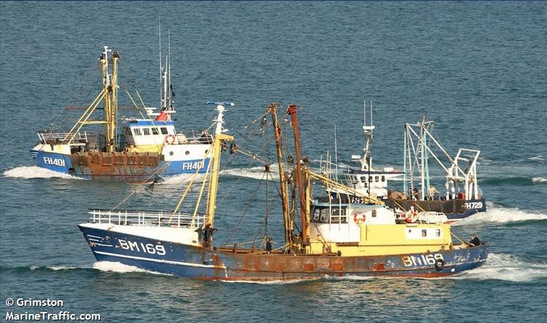
Any boat or ship is likely to just "brush Snoopy aside", without harm to either. However,
fishing nets may spread over a wider area, and so are of major concern to us. Also, a smaller fishing
boat may be more "curious", and decide to pick up Snoopy, to see what he's up to. Both types of incident
have happened to Microtransat teams over the years. A good source of information for us is
www.marinetraffic.com, that shows the detailed
ship movements, reported by their AIS systems - not military ships, as we discovered in 2012 ! :-)
Very useful "traffic density maps" have been used to choose better waypoint positions,
to reduce the risk of Snoopy straying into particular areas.
The picture on the right is based on one from Dick, suggesting different waypoints, to avoid
these popular fishing spots. Our waypoints had already been chosen to avoid those busy traffic lanes
to the south, but now we are looking at moving them again.
Changes to the software to move a waypoint, involve changing the numbers used for it's latitude/longitude.
If it moves east or west, we will probably need to update the "routing boxes" too.
We only have three bytes of memory free, so Robin would prefer not to add more waypoints :-)
More here, when we have reached a conclusion of what changes to make.
Thursday 18th December:
Peter and Dick have been advising Robin to make relatively minor changes to Snoopy's autopilot software,
such as move waypoints to avoid areas of intense fishing, between Weymouth and Torquay ( "Prawle" ).
Click on these pictures to see the larger versions.
Robin hates making even the slightest of software change, because he makes mistakes, and because
"documentation", like maps on these pages, may need to be updated. BUT it is clear that the risk to
Snoopy of a fishing boat, is far higher than the larger ships in the busy shipping lanes.
Any boat or ship is likely to just "brush Snoopy aside", without harm to either. However,
fishing nets may spread over a wider area, and so are of major concern to us. Also, a smaller fishing
boat may be more "curious", and decide to pick up Snoopy, to see what he's up to. Both types of incident
have happened to Microtransat teams over the years. A good source of information for us is
www.marinetraffic.com, that shows the detailed
ship movements, reported by their AIS systems - not military ships, as we discovered in 2012 ! :-)
Very useful "traffic density maps" have been used to choose better waypoint positions,
to reduce the risk of Snoopy straying into particular areas.
The picture on the right is based on one from Dick, suggesting different waypoints, to avoid
these popular fishing spots. Our waypoints had already been chosen to avoid those busy traffic lanes
to the south, but now we are looking at moving them again.
Changes to the software to move a waypoint, involve changing the numbers used for it's latitude/longitude.
If it moves east or west, we will probably need to update the "routing boxes" too.
We only have three bytes of memory free, so Robin would prefer not to add more waypoints :-)
More here, when we have reached a conclusion of what changes to make.
Friday 19th December (to be updated after Dick and Robin compare notes):
 Robin and Dick grabbed the opportunity of 15 to 20 mph wind for "weather helm tests" on Bray Lake,
first without, then with a temporary skeg. We also tried Dick's crazy idea of hiring a kayak,
to tow Snoopy to different positions, instead of using the services of the clubhouse rescue boat.
The bad news was that the GPS Logger got wet, and the valuable GPS plot was lost.
So all we have is the video shot from shore, and Dick's helmet camera, with our memory
of what happened. i.e. Snoopy's sailing behaviour, with and without the skeg.
From Robin's memory, before looking at the video, Snoopy did as well as could be expected
in the strong wind. i.e. very slow progress upwind, but he was changing tack OK.
Slight lee helm with the skeg.
The good news is that the GPS Logger works, after drying out in Robin's boiler room,
then testing with a walk around Armitage Court.
Robin and Dick grabbed the opportunity of 15 to 20 mph wind for "weather helm tests" on Bray Lake,
first without, then with a temporary skeg. We also tried Dick's crazy idea of hiring a kayak,
to tow Snoopy to different positions, instead of using the services of the clubhouse rescue boat.
The bad news was that the GPS Logger got wet, and the valuable GPS plot was lost.
So all we have is the video shot from shore, and Dick's helmet camera, with our memory
of what happened. i.e. Snoopy's sailing behaviour, with and without the skeg.
From Robin's memory, before looking at the video, Snoopy did as well as could be expected
in the strong wind. i.e. very slow progress upwind, but he was changing tack OK.
Slight lee helm with the skeg.
The good news is that the GPS Logger works, after drying out in Robin's boiler room,
then testing with a walk around Armitage Court.
 Two things showed up on the hardware front: before leaving for Bray Lake, Robin saw the rudder
needed to be centred again. Then he was surprised to see the double Z link had been replaced
by the one with a screw clevis ? On 13th ? At one stage in the sailing, we saw that the rudder had shifted,
and the cause was that the lever on top of the servo had turned on it's spline. The servo had
been changed, after the last attempt, but not the servo lever. This has now been done,
but the link with the clevis is retained, for now, since it is easier to adjust.
The double-Z link was introduced because, on one occasion, the welded pin inside the clevis had broken !
Two things showed up on the hardware front: before leaving for Bray Lake, Robin saw the rudder
needed to be centred again. Then he was surprised to see the double Z link had been replaced
by the one with a screw clevis ? On 13th ? At one stage in the sailing, we saw that the rudder had shifted,
and the cause was that the lever on top of the servo had turned on it's spline. The servo had
been changed, after the last attempt, but not the servo lever. This has now been done,
but the link with the clevis is retained, for now, since it is easier to adjust.
The double-Z link was introduced because, on one occasion, the welded pin inside the clevis had broken !
Saturday 20th December:
See the 5 minute youtube
Video of Snoopy's Strong Wind Test.
 Sunday 21st December:
Dick has explained how to make use of a "waypoint" facility in marinetraffic.com : Click on the the left image
to see the detail.
It shows the waypoints, currently in the autopilot, that we are considering changing, to minimise
risks, such as bumping into land or fishing nets. I added the waypoint labels with Paint,
but the rest is a screen-grab from marinetraffic.com. You display the individual boats,
then right click on one to create a waypoint. You can then create a sequence of waypoints.
Each can be moved to the required position, and finally you can select what you want displayed
in the final image. Thanks Dick: this will save a lot of work in discussing and documenting
our final waypoint positions.
Sunday 21st December:
Dick has explained how to make use of a "waypoint" facility in marinetraffic.com : Click on the the left image
to see the detail.
It shows the waypoints, currently in the autopilot, that we are considering changing, to minimise
risks, such as bumping into land or fishing nets. I added the waypoint labels with Paint,
but the rest is a screen-grab from marinetraffic.com. You display the individual boats,
then right click on one to create a waypoint. You can then create a sequence of waypoints.
Each can be moved to the required position, and finally you can select what you want displayed
in the final image. Thanks Dick: this will save a lot of work in discussing and documenting
our final waypoint positions.
AUTOP6TTS.BAS autopilot software update: we can now do a fast test Base->Delta->Base, without a Kayak. Logic was put back
in to set the destination to Delta if the boat is carried near the Clubhouse. The required memory was freed up by
removing the Armitage Court waypoints, now only used in "tea-tray tests". Peter found a bug, now corrected,
where Snoopy would aim for the 7.5W Start Line, instead of Weymouth, when he reached Channel.
June dragged me around Guildford, including
into Lakeland: I got a Sistema KLIP IT 450ml sealed box for the GPS Logger, and "balanzza" digital weigh scales. These say
Boat 10 weighes 15.12kg - the old "Axon" scales say 15.2kg.
Waypoint positions, not yet changed in the software, are:
Channel = 50 30'N 1 40'W,
Weymouth = 50 20'N 2 20'W,
Prawle = 50 00'N 3 40'W,
Lizard = 49 40'N 5 15'W,
Start Line= 49 00'N 7 30'W.
Weymouth is new, having been added after the last 2014 attempt. All these positions are now being reviewed,
to minimise risk, as discussed above. After we've agreed their new positions, the AUTOP6TTS autopilot software
will be updated. Maybe it should be AUTOP7TTS.BAS :-)
Monday 22nd December:
AUTOP6TTS loaded into Boat and "Tea-Tray" autopilots. This is better for "strong wind testing" and ready for 2015.
However, AUTOP7TTS.BAS was copied from it, ready for more changes, such as new waypoint positions.
 Tuesday 23rd December:
Click on the maps to left and right to see the revised waypoint positions, still being discussed, before
updates are made to AUTOP7TTS, the Picaxe autopilot software.
These positions are:
Channel = 50 30'N 1 40'W (unchanged),
Weymouth = 50 09'N 2 20'W (11' south),
Prawle = 49 50'N 3 40'W (10' south),
Lizard = 49 20'N 5 15'W (20' south),
* Start Line= 48 00'N 12 00'W (to new Microtransat Start Line, 300+ miles south west of Lizard).
These changes, of moving Snoopy's route south, nearer to the main traffic lane, are intended to reduce the more serious risks
of bumping into land, or fishing boat nets. The ships themselves are a less serious threat.
Tuesday 23rd December:
Click on the maps to left and right to see the revised waypoint positions, still being discussed, before
updates are made to AUTOP7TTS, the Picaxe autopilot software.
These positions are:
Channel = 50 30'N 1 40'W (unchanged),
Weymouth = 50 09'N 2 20'W (11' south),
Prawle = 49 50'N 3 40'W (10' south),
Lizard = 49 20'N 5 15'W (20' south),
* Start Line= 48 00'N 12 00'W (to new Microtransat Start Line, 300+ miles south west of Lizard).
These changes, of moving Snoopy's route south, nearer to the main traffic lane, are intended to reduce the more serious risks
of bumping into land, or fishing boat nets. The ships themselves are a less serious threat.
 Click on the map on the right to see the detail of waypoint routing "boxes", for discussion,
before these are used for the changed routing logic within the AUTOP7TTS software.
Note that Snoopy will steer towards "Channel" until south of that waypoint.
That includes if he is unlucky enough to get close to Weymouth.
Note the Isle of Wight protection line is still there, making him
steer westward to Prawle, if in danger of getting too close to the Solent.
Most of the logic is simple "switching of destination" based on Longitude.
All of this logic is only exercised if east of Longitude 12W - past the Start Line.
Click on the map on the right to see the detail of waypoint routing "boxes", for discussion,
before these are used for the changed routing logic within the AUTOP7TTS software.
Note that Snoopy will steer towards "Channel" until south of that waypoint.
That includes if he is unlucky enough to get close to Weymouth.
Note the Isle of Wight protection line is still there, making him
steer westward to Prawle, if in danger of getting too close to the Solent.
Most of the logic is simple "switching of destination" based on Longitude.
All of this logic is only exercised if east of Longitude 12W - past the Start Line.
 Wednesday 24th December:
* Corrections to Microtransat Start Line --> 48 00'N 12 00'W in pictures, etc.
I've done a bit of clearing up, and June is cooking xmas stuff, so I sneaked
to the PC and edited the changes into AUTOP7TTS, tidied it up a bit,
and loaded it into the "tea tray" autopilot. Works OK with a real GPS,
but I've not yet managed to get the GPS Simulator working.
Wednesday 24th December:
* Corrections to Microtransat Start Line --> 48 00'N 12 00'W in pictures, etc.
I've done a bit of clearing up, and June is cooking xmas stuff, so I sneaked
to the PC and edited the changes into AUTOP7TTS, tidied it up a bit,
and loaded it into the "tea tray" autopilot. Works OK with a real GPS,
but I've not yet managed to get the GPS Simulator working.
Saturday 27th December:
GPS Simulator working on Laptop with AUTOP7TTS: Looks OK. Simulator not yet working on desktop PC. Folder differences ?
 Sunday 28th December:
The GPS Simulator now works on both this desktop Win7 PC and the XP Laptop. Solution was to merge files
from the Laptop \gpsssimu folder to the desktop PC.
The simulation seems to run correctly, with AUTOP7TTS giving the correct waypoint directions and rudder laft/right
steering. Two maps, CHANNEL.BMP and MIDCHAN.BMP were updated, using Paint, to show new waypoints. Click on images here,
to see detail. The gpsssimu.zip was uploaded. I'm now ready for things like more thorough testing, review of code, etc.
Sunday 28th December:
The GPS Simulator now works on both this desktop Win7 PC and the XP Laptop. Solution was to merge files
from the Laptop \gpsssimu folder to the desktop PC.
The simulation seems to run correctly, with AUTOP7TTS giving the correct waypoint directions and rudder laft/right
steering. Two maps, CHANNEL.BMP and MIDCHAN.BMP were updated, using Paint, to show new waypoints. Click on images here,
to see detail. The gpsssimu.zip was uploaded. I'm now ready for things like more thorough testing, review of code, etc.
Wednesday 7th January 2015: I noticed the Spot3 transmissions had slowed down then stopped in past 24 hours, and - no surprise - the recent weeks indoors, without direct sunlight, meant the power systems had run low. Main 5v was 3.86,4.34->4.2v. The solution for this was to put the boat outside, on the patio. The autopilot is switched off. The SPOT power was then inspected: internal Ni-Me cells were 1.6+1.46v and were swapped for charged cells of 1.76+1.76v. The three NiMH had dropped to 3.07v and this pack was fast charged at 1A for 10mins -> 4.08v. The two Zenar diodes, protecting the SPOT supply from solar over-charging were not soldered on - but are now ! After connecting together, the measured SPOT voltage was 3.89v. The Spot3 was restarted at 1130, and the boat put outside.
Thursday 8th January:
After discussion with Dick, the position of the "Prawle" waypoint was moved north by 5' (5 nautical miles) to avoid
getting close to the dense traffic lane. The Picaxe Autopilot program, AUTOP7TTS.BAS was updated to change this position
and the spoken startup message to "Autopilot 7. Last change 8 January 2015". This was loaded into both the "teatray"
and Boat 10 autopilots. Changes are being made to "Snoopy's Front Page", including the map showing the planned route
from UK to Atlantic in 2015. Click on map to see details. Code is being emailed to Peter and Dick for review.
Saturday 10th January:
Spot3 transmissions every hour still OK, but main 5v power has dropped, with flat batteries: (5.1,4.5->4.45v when OFF, BUT
drop below 3v when autopilot switched on). Switching on autopilot does not give usual waggle of rudder. We need to check both
batteries and duplicated solar panels for faults. Remember, it's been cloudy in recent days, and my patio does not get much sun.
Wires were unsoldered from the duplicated 5v packs, and mA meter tests showed zero current from the RHS panels. These are older,
and appear "grey". Four new 6v 250mA 130x130mm panels were ordered from FirstStopSolar at Ł60. The two packs were fast-charged @1A.
Both reached 5.43v by 3pm, the fast-charger tripping out every 5 minutes.
 MAYBE SNOOPY CRASHED INTO PORTLAND WITH FLAT BATTERIES ? Food for thought ? We have been assuming things like weather helm
to explain Snoopy's failure to "turn right", in those hours prior to hitting the coast near Portland. The Main 5v supply was
flat when we checked, the next day, and we put that down to the rudder servo having stalled. But maybe the batteries went flat
during those three days at sea ? No way of knowing for sure, but at least we can fix the 5v power now !
The RHS Solar panel was lifted: YUK ! Click on the picture on left, to see how bad it is: let's check earlier blogs ...
e.g. the "February 2013 re-build" on
Blog2, nearly a year ago. That may be when the RHS panel was last inspected.
Then lots of sailing on Bray Lake before the September attempt, ending on the Isle of Wight. Not until October was the LHS
(not this RHS) panel replaced. i.e. earlier tests may have shown the RHS panel to be OK, but corrosion could still
have been at work ! Closer inspection of the faulty RHS panel revealed that 3 of the 4 diodes and panels were OK,
still protected by resin, but the 4th diode and positive lead had broken. It was decided to replace the whole RHS panel,
after the new cells arrive soon, as we did the LHS in 2014. The RHS 5v (Maplins) 4xNiMH pack was reconnected,
and the autopilot switched on as a battery test. The current drawn was 40mA, so this 2000mAH pack should last 50 hours.
Another new (Maplin) pack was assembled as a spare, and put on charge.
MAYBE SNOOPY CRASHED INTO PORTLAND WITH FLAT BATTERIES ? Food for thought ? We have been assuming things like weather helm
to explain Snoopy's failure to "turn right", in those hours prior to hitting the coast near Portland. The Main 5v supply was
flat when we checked, the next day, and we put that down to the rudder servo having stalled. But maybe the batteries went flat
during those three days at sea ? No way of knowing for sure, but at least we can fix the 5v power now !
The RHS Solar panel was lifted: YUK ! Click on the picture on left, to see how bad it is: let's check earlier blogs ...
e.g. the "February 2013 re-build" on
Blog2, nearly a year ago. That may be when the RHS panel was last inspected.
Then lots of sailing on Bray Lake before the September attempt, ending on the Isle of Wight. Not until October was the LHS
(not this RHS) panel replaced. i.e. earlier tests may have shown the RHS panel to be OK, but corrosion could still
have been at work ! Closer inspection of the faulty RHS panel revealed that 3 of the 4 diodes and panels were OK,
still protected by resin, but the 4th diode and positive lead had broken. It was decided to replace the whole RHS panel,
after the new cells arrive soon, as we did the LHS in 2014. The RHS 5v (Maplins) 4xNiMH pack was reconnected,
and the autopilot switched on as a battery test. The current drawn was 40mA, so this 2000mAH pack should last 50 hours.
Another new (Maplin) pack was assembled as a spare, and put on charge.
 Sunday 11th January:
Both 5v packs failed the test (maybe the clue was the charger tripping out every 5 minutes ?). RHS (Maplin) pack was
flat by morning. LHS ("Hi Energy") Pack lasted less than 5 hours, dropping from 5.24v to 2.75v.
So, both these packs were changed: the RHS to the new Maplin pack made yesterday, and the LHS for a "2600" pack,
re-charged, previously used on the "tea-tray" system. The I-Got GPS logger was seen to be flat, so was recharged
by connecting to a PC via it's USB cable.
Peter reported a bug
in the Picaxe Autopilot software AUTOP7TTS.BAS and this was corrected, including the startup speech now saying "11 January",
and loaded into both "tea-tray" and Boat 10 autopilots. The original code was checked, and this bug was not in the
boat that made the last attempt in 2014.
New code was emailed, to look for more bugs.
Later in the day, after feedback from Peter, more corrections were made to the software, including putting (back) in
the "Weymouth" waypoint ! Updated versions were emailed back, BUT NOT YET LOADED INTO THE HARDWARE.
Thanks Peter :-)
Sunday 11th January:
Both 5v packs failed the test (maybe the clue was the charger tripping out every 5 minutes ?). RHS (Maplin) pack was
flat by morning. LHS ("Hi Energy") Pack lasted less than 5 hours, dropping from 5.24v to 2.75v.
So, both these packs were changed: the RHS to the new Maplin pack made yesterday, and the LHS for a "2600" pack,
re-charged, previously used on the "tea-tray" system. The I-Got GPS logger was seen to be flat, so was recharged
by connecting to a PC via it's USB cable.
Peter reported a bug
in the Picaxe Autopilot software AUTOP7TTS.BAS and this was corrected, including the startup speech now saying "11 January",
and loaded into both "tea-tray" and Boat 10 autopilots. The original code was checked, and this bug was not in the
boat that made the last attempt in 2014.
New code was emailed, to look for more bugs.
Later in the day, after feedback from Peter, more corrections were made to the software, including putting (back) in
the "Weymouth" waypoint ! Updated versions were emailed back, BUT NOT YET LOADED INTO THE HARDWARE.
Thanks Peter :-)
 Monday 12th January:
The brass turnbuckles arrived today, and one was used to make a more easily adjustable servo-rudder push rod.
It was not too difficult to make, from standard push rod wire, copper flex, and soldering. Note in the left picture,
the linkage would be turned 180 degrees, so it is in a straight line.
It was more difficult to install: the first time, the turnbuckle was higher, and hit the plastic sheet
that supports the I-GotU. With the turnbuckle lower, it seems OK, but it was not easy to assemble.
We will see if there are any problems in use: note that we've had welded pins fall out (after months of operation)
of the standard clevis you see in top left. This approach, suggested by Dick, should give the reliability
of a double-Z push rod, but be adjustable - before use of Loctite ! :-)
Monday 12th January:
The brass turnbuckles arrived today, and one was used to make a more easily adjustable servo-rudder push rod.
It was not too difficult to make, from standard push rod wire, copper flex, and soldering. Note in the left picture,
the linkage would be turned 180 degrees, so it is in a straight line.
It was more difficult to install: the first time, the turnbuckle was higher, and hit the plastic sheet
that supports the I-GotU. With the turnbuckle lower, it seems OK, but it was not easy to assemble.
We will see if there are any problems in use: note that we've had welded pins fall out (after months of operation)
of the standard clevis you see in top left. This approach, suggested by Dick, should give the reliability
of a double-Z push rod, but be adjustable - before use of Loctite ! :-)
Tuesday 13th January: The autopilot software was loaded into "tea-tray" and Boat 10 hardware. Startup speech says "Autopilot 7 Changed 11 January 2015".
 Thursday 15th January:
The four 6v250mA solar panels arrived from FirstStopSolar and were joined with FastGlass resin and fibreglass matt strips
where they meet. The diodes supplied with them were soldered on, with the wires, running along the panels.
Thursday 15th January:
The four 6v250mA solar panels arrived from FirstStopSolar and were joined with FastGlass resin and fibreglass matt strips
where they meet. The diodes supplied with them were soldered on, with the wires, running along the panels.
 These were all
"glued down" with more FastGlass resin and F/G matting. All electrode strips were coated in FastGlass resin.
When dry, the whole back was covered in a liberal coat of yacht varnish. On the left is a closeup of where
the two wires leave the panel. This time patches of F/G were also placed over the diodes.
These were all
"glued down" with more FastGlass resin and F/G matting. All electrode strips were coated in FastGlass resin.
When dry, the whole back was covered in a liberal coat of yacht varnish. On the left is a closeup of where
the two wires leave the panel. This time patches of F/G were also placed over the diodes.
Friday 16th January:
The four-panel assembly was soldered
and "glued" onto the Boat10 deck, using silicon sealant.
Saturday 17th January:
Email discussion with Roy and Dick cast some doubt on how long that brass turnbuckle based servo link,
shown above, might survive,
due to continuous use and brass metal fatigue. On the right is a new idea, which seems simpler and more robust:
remove three bits from a terminal block, and squeeze in two simple Z-bend push rods. That's six screws that would need
to come loose, and lots of area for Loctite ! This "terminal block push rod" now replaces the "turn-buckle" one.
But no Loctite yet :-)
 Sunday 18th January:
All the boats in recent years have used the same product,
purchased from Mantua Models: the packet says "LOGIC Accessories Steering Arm for Noselegs 6g". See
www.logicrc.com page
and picture on the left.
We've only had one break, after years of use,
and several "crash landings" at sea. This may have broken during it's time on the rocks in December 2014,
but it was not too difficult to strengthen: see right. Push-rod wire was bent to go around the slightly shortened arm (we don't
use the end hole). A small soldering iron was used to make indents near the centre bush. Cotton is wrapped around
the wire and arm, tacked with superglue. More cotton is wound around, and soaked in Fastglass resin.
The new, strengthened rudder arm is now in Boat10, with the new, "terminal block" push rod. Blue Loctite was put on the
top of the rudder post and all screws. We will watch carefully for any "rudder bias" during Bray Lake Tests.
Sunday 18th January:
All the boats in recent years have used the same product,
purchased from Mantua Models: the packet says "LOGIC Accessories Steering Arm for Noselegs 6g". See
www.logicrc.com page
and picture on the left.
We've only had one break, after years of use,
and several "crash landings" at sea. This may have broken during it's time on the rocks in December 2014,
but it was not too difficult to strengthen: see right. Push-rod wire was bent to go around the slightly shortened arm (we don't
use the end hole). A small soldering iron was used to make indents near the centre bush. Cotton is wrapped around
the wire and arm, tacked with superglue. More cotton is wound around, and soaked in Fastglass resin.
The new, strengthened rudder arm is now in Boat10, with the new, "terminal block" push rod. Blue Loctite was put on the
top of the rudder post and all screws. We will watch carefully for any "rudder bias" during Bray Lake Tests.
 Tuesday 20th January:
NEW AUTOPILOT FAULT ! Decided to put the Boat10 system outside, on 24/7 test, and a new fault surfaced:
the autopilot starts OK, with a waggle of the rudder and speaking the correct startup message. The GPS is flashing OK,
but there are no further 7 second rudder twitches, as is normal. Reloading software did not help. Same software
works OK on tea-tray system. Maybe a wire has decided to break ? Same software now loaded into the third autopilot,
that was in Boat11 for experiment. Next it's out with the wire snippers and soldering iron....
On the right is the "lunchbox" after replacing the autopilot, including GPS and Picaxe inside the pillbox.
The GPS normally sits over the pillbox, with the lid screwed on.
The terminal block simply holds four brass screws, to which everything is soldered: ov, +5v, servo signal, TTS signal.
During many tests, through stages of assembly, autopilots seemed slow to start tracking, but the old etrex worked outside.
Boat10 was put outside, on 24/7 test, watched by CCTV, soon after 1600.
It was still running OK at 1800.
Hopefully, tests on the original autopilot, encapsulated in candle wax, may show what the fault was. Few things could explain it,
other than a break in the GPS signal wire. First tests, soldering another (G-Star IV) GPS to three snipped wires from
the old pillbox indicate the GPS wiring inside is suspect. How to melt that candle wax inside the pill box ? :-)
Tuesday 20th January:
NEW AUTOPILOT FAULT ! Decided to put the Boat10 system outside, on 24/7 test, and a new fault surfaced:
the autopilot starts OK, with a waggle of the rudder and speaking the correct startup message. The GPS is flashing OK,
but there are no further 7 second rudder twitches, as is normal. Reloading software did not help. Same software
works OK on tea-tray system. Maybe a wire has decided to break ? Same software now loaded into the third autopilot,
that was in Boat11 for experiment. Next it's out with the wire snippers and soldering iron....
On the right is the "lunchbox" after replacing the autopilot, including GPS and Picaxe inside the pillbox.
The GPS normally sits over the pillbox, with the lid screwed on.
The terminal block simply holds four brass screws, to which everything is soldered: ov, +5v, servo signal, TTS signal.
During many tests, through stages of assembly, autopilots seemed slow to start tracking, but the old etrex worked outside.
Boat10 was put outside, on 24/7 test, watched by CCTV, soon after 1600.
It was still running OK at 1800.
Hopefully, tests on the original autopilot, encapsulated in candle wax, may show what the fault was. Few things could explain it,
other than a break in the GPS signal wire. First tests, soldering another (G-Star IV) GPS to three snipped wires from
the old pillbox indicate the GPS wiring inside is suspect. How to melt that candle wax inside the pill box ? :-)
 Wednesday 21st January:
Old GPS is OK with tea-tray system. Checks with meter indicate possible failure of BOTH ov and signal wire from GPS into Pillbox.
The replaced autopilot ran all night, and main 5v power had dropped to 4.39v by 0945 (4.68,4.66->4.39v). Despite cloudy conditions,
this had risen to 4.41v by 1100 (4.7,4.65->4.41v).
SPOT SOLAR PANEL FAILURE:
The Spot3 reporting had started to slow down by 8pm yesterday, from 1 hour
to ~ 1.25 hour - a sure sign of Spot power running low. This was 3.32v @ 1100: the fully charged level is 3.6v. We need to check
wiring from the dedicated Spot3 13x13cm solar panel, at the front of the boat... Removal of the SPOT solar panel revealed
a break due to corrosion. There was also a hidden break in the +ve wire running back to the "lunchbox" at the back.
Solution was to run two new wires along the centre of boat into the box, and replace the solar panel, by one slightly
less "weathered" in appearance. This gave 5mA instead of 3mA in the dull conditions. Two isolation diodes in parallel
were soldered on, and the lot covered in Fastglass resin. The two "Do not Touch" labels were removed, so the new wires
could run under the labels and into the front of the box, about 1"/25mm above the deck. The larger label had de-laminated,
exposing the paper, so this was re-laminated, before everything was sealed and glued down with the trusty silicon sealant.
Wednesday 21st January:
Old GPS is OK with tea-tray system. Checks with meter indicate possible failure of BOTH ov and signal wire from GPS into Pillbox.
The replaced autopilot ran all night, and main 5v power had dropped to 4.39v by 0945 (4.68,4.66->4.39v). Despite cloudy conditions,
this had risen to 4.41v by 1100 (4.7,4.65->4.41v).
SPOT SOLAR PANEL FAILURE:
The Spot3 reporting had started to slow down by 8pm yesterday, from 1 hour
to ~ 1.25 hour - a sure sign of Spot power running low. This was 3.32v @ 1100: the fully charged level is 3.6v. We need to check
wiring from the dedicated Spot3 13x13cm solar panel, at the front of the boat... Removal of the SPOT solar panel revealed
a break due to corrosion. There was also a hidden break in the +ve wire running back to the "lunchbox" at the back.
Solution was to run two new wires along the centre of boat into the box, and replace the solar panel, by one slightly
less "weathered" in appearance. This gave 5mA instead of 3mA in the dull conditions. Two isolation diodes in parallel
were soldered on, and the lot covered in Fastglass resin. The two "Do not Touch" labels were removed, so the new wires
could run under the labels and into the front of the box, about 1"/25mm above the deck. The larger label had de-laminated,
exposing the paper, so this was re-laminated, before everything was sealed and glued down with the trusty silicon sealant.
Thursday 22nd January:AUTOPILOT SOFTWARE CHANGE NEEDED. Peter pointed out bugs in AUTOP4TTS, the Picaxe autopilot software,
which made Snoopy vulnerable to missing the 25km radius target around 24 30'N on the 60W Microtransat Finish Line,
and/or getting stuck near the line, before sailing nor-nor-west towards Bermuda and then the USA. So a change in the software
must be made carefully. I considered making the attempted accuracy much better than the 25km (13.5NM)
required by the Microtransat Rules. e.g. 1km,
or even 100m. It would have been a tradeoff of accuracy with how long this adds to the mission, with typical weather conditions, etc.
However, when making changes for Peter's review, I found this too difficult within the tight memory: we now have only 6 bytes free,
after a tidy up, correcting mistakes, and introducing a new "b4finish" waypoint, 60NM east of the Finish Line waypoint.
 SOLAR PANEL AND SPOT WIRING FAULTS: Boat10 had been put outside, at 0845, to test the repaired solar panel hardware. Main power was 4.45v at 0845 (4.63,4.63->4.45v).
Spot3 power was 3.14v. The autopilot remains OFF, so the batteries can re-charge.
In a brightening sky, main power was up to 4.78v (4.92,4.71->4.78v) by 1005 and Spot3 was 3.69v - back up above the nominal 3.6v.
Spot3 reporting rate was still every 1.25 hours at 1037, but is now expected to return to every hour*
At 1330, main power was (5.22,4.73->5.06v). 4.73v (RHS) not increasing ??? Spot3 power up to 3.94v but still not yet every hour (1307).
Eventually, after removing the RHS solar panel (again!), a broken wire was found - see that green corrosion !
Earlier searching the "rat's nest" of wires inside the box also revealed a dry joint at 0v terminal. This was re-soldered.
The two wires from the box to the solar panel were OK (tinned multi-core), and so the new wires from the RHS panel were
soldered on, shrink wrapped sleeved and the panel glued down (again!) with silicon sealant.
* Spot3 transmissions were still every 1.25 hours, after the voltage from the solar panel and external pack was above 3.6v.
The SPOT Messenger cover was removed and the internal batteries were only 3.32v - no connection between them and the external ones !
Broken (but not corroded) wires were found and re-soldered. It was noticed that we are still using duplicated Futaba connectors.
One sides was permanently soldered, without a connector, from Picaxe timer to SPOT Messenger, and to SPOT 3.6v supply. The good news, is that during this work, no signs
of moisture or corrosion were found inside the box.
SOLAR PANEL AND SPOT WIRING FAULTS: Boat10 had been put outside, at 0845, to test the repaired solar panel hardware. Main power was 4.45v at 0845 (4.63,4.63->4.45v).
Spot3 power was 3.14v. The autopilot remains OFF, so the batteries can re-charge.
In a brightening sky, main power was up to 4.78v (4.92,4.71->4.78v) by 1005 and Spot3 was 3.69v - back up above the nominal 3.6v.
Spot3 reporting rate was still every 1.25 hours at 1037, but is now expected to return to every hour*
At 1330, main power was (5.22,4.73->5.06v). 4.73v (RHS) not increasing ??? Spot3 power up to 3.94v but still not yet every hour (1307).
Eventually, after removing the RHS solar panel (again!), a broken wire was found - see that green corrosion !
Earlier searching the "rat's nest" of wires inside the box also revealed a dry joint at 0v terminal. This was re-soldered.
The two wires from the box to the solar panel were OK (tinned multi-core), and so the new wires from the RHS panel were
soldered on, shrink wrapped sleeved and the panel glued down (again!) with silicon sealant.
* Spot3 transmissions were still every 1.25 hours, after the voltage from the solar panel and external pack was above 3.6v.
The SPOT Messenger cover was removed and the internal batteries were only 3.32v - no connection between them and the external ones !
Broken (but not corroded) wires were found and re-soldered. It was noticed that we are still using duplicated Futaba connectors.
One sides was permanently soldered, without a connector, from Picaxe timer to SPOT Messenger, and to SPOT 3.6v supply. The good news, is that during this work, no signs
of moisture or corrosion were found inside the box.
Friday 23rd January:
 Click on the map on the right to see the details. The GPS Simulator maps are being updated, in preperation for simulation
tests on the autopilot program AUTOP7TTS, the script of which "sails" Snoopy from UK to USA. Hardware tests continue:
the autopilot was switched on for an hour, then switched off and put outside at 0820 with main 5v power at (4.76,4.70->4.59v)
and SPOT power 3.38v. By 0920 these had risen to (4.86,4.97->4.77v) and 3.46v, before sun had reached solar panels.
This time we will see if everything charges up as it should, including both sides of the duplicated 5v supply.
As expected, the Spot3 reporting resumed it's normal hourly rate, after SPOT power was it's normal level, yesterday evening.
Duplicated 5v power rose from (5.04,5.26->5.02v) & SPOT 3.54v @ 1105 to (5.34,5.49->5.23v) & SPOT 3.67v @ 1400
when autopilot was switched ON. Now left ON and (5.28,5.33->5.05v) & SPOT 3.60v @ 1555 after hours of weak and low sun.
Click on the map on the right to see the details. The GPS Simulator maps are being updated, in preperation for simulation
tests on the autopilot program AUTOP7TTS, the script of which "sails" Snoopy from UK to USA. Hardware tests continue:
the autopilot was switched on for an hour, then switched off and put outside at 0820 with main 5v power at (4.76,4.70->4.59v)
and SPOT power 3.38v. By 0920 these had risen to (4.86,4.97->4.77v) and 3.46v, before sun had reached solar panels.
This time we will see if everything charges up as it should, including both sides of the duplicated 5v supply.
As expected, the Spot3 reporting resumed it's normal hourly rate, after SPOT power was it's normal level, yesterday evening.
Duplicated 5v power rose from (5.04,5.26->5.02v) & SPOT 3.54v @ 1105 to (5.34,5.49->5.23v) & SPOT 3.67v @ 1400
when autopilot was switched ON. Now left ON and (5.28,5.33->5.05v) & SPOT 3.60v @ 1555 after hours of weak and low sun.
 Saturday 24th January: Now testing hardware and software: hardware with 24/7 tests on patio,
and software with the GPS Simulator.
HARDWARE: from CCTV, the autopilot stopped after 0430 due to low power.
No big surprise, because fully charged 5v would be nearer 5.6,5.6 - not the max of 5.28,5.33 seen yesterday.
Spot3 reporting also slowed to every 1.25 hours at about 3am. Power checks at 0850: Main 5v (3.37,3.37->3.13v) SPOT: 3.38v.
In clear sky, power had
risen by 1020 to (3.41,3.44->3.18v) SPOT 3.42 with regular 1Hz rudder twitching. By 1030, the very low sun was starting
to hit the solar panels, and the autopilot was running again: (4.4,4.36->4.1v) SPOT 3.46v.
By 1230 voltages had risen to main 5v (5.02,5.10->4.83v) SPOT 3.53v and Spot3 was reporting every hour by 1230.
By 1415, in low sun, voltages were (5.32,5.38->5.1v) SPOT 3.61. At 1600 they were (5.22,5.22->4.96v) SPOT 3.55v.
i.e. lower than yesterday, so can expect failure earlier tonight.
Saturday 24th January: Now testing hardware and software: hardware with 24/7 tests on patio,
and software with the GPS Simulator.
HARDWARE: from CCTV, the autopilot stopped after 0430 due to low power.
No big surprise, because fully charged 5v would be nearer 5.6,5.6 - not the max of 5.28,5.33 seen yesterday.
Spot3 reporting also slowed to every 1.25 hours at about 3am. Power checks at 0850: Main 5v (3.37,3.37->3.13v) SPOT: 3.38v.
In clear sky, power had
risen by 1020 to (3.41,3.44->3.18v) SPOT 3.42 with regular 1Hz rudder twitching. By 1030, the very low sun was starting
to hit the solar panels, and the autopilot was running again: (4.4,4.36->4.1v) SPOT 3.46v.
By 1230 voltages had risen to main 5v (5.02,5.10->4.83v) SPOT 3.53v and Spot3 was reporting every hour by 1230.
By 1415, in low sun, voltages were (5.32,5.38->5.1v) SPOT 3.61. At 1600 they were (5.22,5.22->4.96v) SPOT 3.55v.
i.e. lower than yesterday, so can expect failure earlier tonight.
 SOFTWARE: the "22Jan" corrected AUTOP7TTS was loaded into the "tea-tray" system, and it works with the GPS Simulator
on the Laptop. A tidied up simulation script was made, for whole route from UK to USA, with the usual deliberately "wobbly"
approaches to each of the waypoints. The UK-USA simulation takes over 15 minutes, and must be watched - looking at
the simulated position of the boat, and the autopilot spoken direction to waypoint and turning instructions,
also seen on the rudder servo. e.g. "270 degrees" (to waypoint due west) "right 40" (degrees to right).
GPS Simulator testing has been started, and results will be reported here... routing logic near USA looks suspect,
and is now getting closer examination.
SOFTWARE: the "22Jan" corrected AUTOP7TTS was loaded into the "tea-tray" system, and it works with the GPS Simulator
on the Laptop. A tidied up simulation script was made, for whole route from UK to USA, with the usual deliberately "wobbly"
approaches to each of the waypoints. The UK-USA simulation takes over 15 minutes, and must be watched - looking at
the simulated position of the boat, and the autopilot spoken direction to waypoint and turning instructions,
also seen on the rudder servo. e.g. "270 degrees" (to waypoint due west) "right 40" (degrees to right).
GPS Simulator testing has been started, and results will be reported here... routing logic near USA looks suspect,
and is now getting closer examination.
Sunday 25th January:
HARDWARE: as expected, the autopilot stopped before midnight, but was running normally again by 0900. At 0815, in the
bright cloudy sky (better than clear when sun low?), the rudder had re-centred from full right. Power at 0930 was
(4.63,4.66->4.37v) SPOT 3.45v and by 1120 was (4.93,5.15->4.90v) SPOT 3.54v. Spot3 reporting had slowed to 1.25 hours
by 1030pm, but was back at 1 hour by 1037. By 1300 power had risen to (5.13,5.35->5.08v) SPOT 3.60v in bright cloud.
SOFTWARE: more checks and tests expected, including numbers related to waypoint locations, exploiting GPSS.PIC in the
GPS Simulator (shows waypoints on maps). e.g. browsing maps using right-clicks and shortcuts such as ?,|,Z,X,Ctrl-D.
The \gpsssimu folder mapping has been updated for use by friends helping check the software.
Click on the larger map to the right, to see the waypoints added from GPSS.PIC (an old, unused GPSS feature from 1996!).
 Monday 26th January:
HARDWARE: Much cloudier today, so batteries not getting enough light to stay charged for long. Autopilot
was switched off at 1300 to give batteries a chance to fully charge. Last night, the autopilot stopped
soon after 8pm, and the Spot3 reporting slowed to 1.25 hours at 2am. It recovered to hourly rate by 1053.
At 1255 voltages were (4.97,5.26->5.01v) SPOT 3.52v. The autopilot re-centered the rudder after ~0830,
but the autopilot was not running when switched off at 1300. Failed to restart ???
Monday 26th January:
HARDWARE: Much cloudier today, so batteries not getting enough light to stay charged for long. Autopilot
was switched off at 1300 to give batteries a chance to fully charge. Last night, the autopilot stopped
soon after 8pm, and the Spot3 reporting slowed to 1.25 hours at 2am. It recovered to hourly rate by 1053.
At 1255 voltages were (4.97,5.26->5.01v) SPOT 3.52v. The autopilot re-centered the rudder after ~0830,
but the autopilot was not running when switched off at 1300. Failed to restart ???
SOFTWARE: Lots more checking and testing of the Picaxe autopilot software have been done.
A new AUTOP8TTS.BAS (copied from AUTOP7TTS, which is now
archived), was checked against the mapping in GPSSSIMU.
Particular attention was paid to the final routing waypoints
and logic, for those last few miles to the USA coast. Click on the chart on the right to see the detail.
A significant bug, dating back three years or more, was found, when the GPS Simulator showed the autopilot steering to
the south, instead of westward, when closing on the "Plymouth Bay" waypoint. This was tracked down to the calculation
of "target heading", described in great detail on the
Autopilot Software Page.
In brief: this bug (or "feature" ?) only happens when switching to logic that uses small waypoint "boxes",
combined with a destination that is not in the same 1x1 degree lat/lon area. The "destination" lat/lon gets
overwritten by code that calculates Target Heading. Fixing of the bug was seen to be extremely difficult,
with the scarce number of registers and memory in the 08M2 (No such problem with the Picaxe 28X2).
The solution was to change a number in the logic, represented by that vertical line through the
Plymouth Bay waypoint. East of there, the destination waypoint lat/lon is recalculated every 7 second cycle,
so it does not matter if it gets overwritten.
This bug would not have surfaced until Snoopy got close to Plymouth Bay. I wonder how long until we know for sure ? :-)
NEW VIDEO: this is an experiment, but you may wish to play some of this
15 minute GPS Simulation Video uploaded to youtube
(but see better one below).
I used my camcorder to film the GPS Simulator laptop display, and listen to the speech from the autopilot.
There is a delay of several seconds, from the GPS data being output from the laptop, and then processed.
So for future videos, we may delay the vision a few seconds, after the sound. The good thing about this
approach is that it should be possible to go quickly to any part of the route, and repeat that part
if it seems there is a problem. Also, others can share the checking. This is more boring than watching
paint dry - but it is noisier ! :-)
Tuesday 27th January:
AUTOP8TTS 26Jan15 was loaded into the Boat10 Autopilot. Voltages: (4.96,5.24->5.0v) SPOT 3.5v. Spot3 still hourly. Still switched off, charging.
At 1500 power had climbed to (5.06,5.5->5.25v) SPOT 3.65v.
There is now a better, edited youtube
Snoopy's GPS Simulation Test Video
that adds a short introduction, and shifts the video back 3 seconds, to compensate for processing delays.
Near the end, Snoopy does not "hit" the "Kingston Bay" waypoint box, so continues steering to it, until "Breakwater".
This was found to be a combination of the simulation script and replay speed (slowed with "<" key).
i.e. no software bug.
 Wednesday 28th January:
Work started on a new solar powered navigation light, since we are using our last "Ultra" spare.
Details are in our "experimental blog" on
BlogX.
Boat 10 is ready for Bray Lake testing, and batteries continue to charge with the autopilot switched off.
In some sun at 1440, power was (5.29,5.55->5.311) SPOT 3.71, and near sunset at 1615, power
had dropped to (5.27,5.49->5.24v) SPOT 3.64v.
Thursday 29th :
(5.28,5.58->5.35v) SPOT 5.75v @ 1230.
Friday 30th :
(5.34,5.6->5.35v) SPOT 3.73v @1350.
Wednesday 28th January:
Work started on a new solar powered navigation light, since we are using our last "Ultra" spare.
Details are in our "experimental blog" on
BlogX.
Boat 10 is ready for Bray Lake testing, and batteries continue to charge with the autopilot switched off.
In some sun at 1440, power was (5.29,5.55->5.311) SPOT 3.71, and near sunset at 1615, power
had dropped to (5.27,5.49->5.24v) SPOT 3.64v.
Thursday 29th :
(5.28,5.58->5.35v) SPOT 5.75v @ 1230.
Friday 30th :
(5.34,5.6->5.35v) SPOT 3.73v @1350.
 Monday 2nd February: Latest News first: Snoopy is back on 24/7 test on Bray Lake. Click on the map on left
to see the live SPOT map, and where he is now.
Above-right is Snoopy just a few yards from the bank of "Snoopy Corner" - stuck in thin ice.
Time will tell, along with the SPOT map, if and when he breaks free, and makes it to his 24/7 position.
Expect the usual "scatter" with the SPOT GPS Position, which may make it look as if Snoopy has come ashore !
Sadly, the wind was too light, for Robin to film him acting as an "ice-breaker".
The ice is thin, and only filling Snoopy Corner. The telescopic pole enabled Robin to push Snoopy out 10 yards,
but throwing pebbles in, did not make big enough holes to provide a channel. Hopefully we will get a thaw or some strong wind !
Monday 2nd February: Latest News first: Snoopy is back on 24/7 test on Bray Lake. Click on the map on left
to see the live SPOT map, and where he is now.
Above-right is Snoopy just a few yards from the bank of "Snoopy Corner" - stuck in thin ice.
Time will tell, along with the SPOT map, if and when he breaks free, and makes it to his 24/7 position.
Expect the usual "scatter" with the SPOT GPS Position, which may make it look as if Snoopy has come ashore !
Sadly, the wind was too light, for Robin to film him acting as an "ice-breaker".
The ice is thin, and only filling Snoopy Corner. The telescopic pole enabled Robin to push Snoopy out 10 yards,
but throwing pebbles in, did not make big enough holes to provide a channel. Hopefully we will get a thaw or some strong wind !
 Earlier, we tried the usual "Bray Lake Test", in a very light wind from West-Nor-West. Snoopy failed to turn right onto his
waypoint "Alpha", and needed a rescue from the far south bank. Next attempt was a little better, and it looks as if he reached
"Alpha", but then hit "Charlie" by mistake, trying to "tack" upwind to "Beta". He then came back OK, via "Delta" to "Base".
If there was any pattern, it seemed as if he had a little lee helm. The only change was lack of the navigation light
(on test in the garden). We need more tests to see if this was it, even though it seems very unlikely.
Click on the GPS Plot on the right, to see the details.
Earlier, we tried the usual "Bray Lake Test", in a very light wind from West-Nor-West. Snoopy failed to turn right onto his
waypoint "Alpha", and needed a rescue from the far south bank. Next attempt was a little better, and it looks as if he reached
"Alpha", but then hit "Charlie" by mistake, trying to "tack" upwind to "Beta". He then came back OK, via "Delta" to "Base".
If there was any pattern, it seemed as if he had a little lee helm. The only change was lack of the navigation light
(on test in the garden). We need more tests to see if this was it, even though it seems very unlikely.
Click on the GPS Plot on the right, to see the details.
 Tuesday 3rd February:
Snoopy spent about 24 hours stuck in the ice, despite what the Spot3 tracker was saying.
Click on the left picture to see the details. Massive and regular "GPS scatter" errors
are not common, unless Snoopy is shielded under trees. The only possible explanation is that snow, on the box, was shielding the tracker.
We saw no such problem with experimental Spot4, in the garden, and we also had snow settle here - just 10 or 20mm.
I was amazed, when I went over to check before 1pm, that there was not a trace of ice to be seen anywhere in Snoopy Corner.
Snoopy was happily holding his 24/7 position - perhaps more accurately than the Spot3 tracker shows here.
Tuesday 3rd February:
Snoopy spent about 24 hours stuck in the ice, despite what the Spot3 tracker was saying.
Click on the left picture to see the details. Massive and regular "GPS scatter" errors
are not common, unless Snoopy is shielded under trees. The only possible explanation is that snow, on the box, was shielding the tracker.
We saw no such problem with experimental Spot4, in the garden, and we also had snow settle here - just 10 or 20mm.
I was amazed, when I went over to check before 1pm, that there was not a trace of ice to be seen anywhere in Snoopy Corner.
Snoopy was happily holding his 24/7 position - perhaps more accurately than the Spot3 tracker shows here.
 Peter has programmed a clever "software rig", to check the logic used within AUTOP8TTS.BAS, the Picaxe autopilot,
for calculation the destination waypoint from the GPS lat/lon. This showed a vulnerabilty in the logic, if storms
blow Snoopy east, into the Bay of Biscay. He risks aiming north, and hitting the French coast.
Click on the map on the right, to see the detail.
Peter has programmed a clever "software rig", to check the logic used within AUTOP8TTS.BAS, the Picaxe autopilot,
for calculation the destination waypoint from the GPS lat/lon. This showed a vulnerabilty in the logic, if storms
blow Snoopy east, into the Bay of Biscay. He risks aiming north, and hitting the French coast.
Click on the map on the right, to see the detail.
Wednesday 4th February: Snoopy is still at his 24/7 position, after 2 days, including the first 24 hours stuck in the ice. The Spot3 Map has been tidied, to suppress Snoopy's time in the ice. We can now watch for him drifting ashore.
Thursday 5th February: Snoopy still at 24/7 postion: that's now 3 days. Made updates to the Picaxe autopilot program, AUTOP8TTS, for testing on the GPS Simulator, and Peter's software test rig. The changes were:
 I moved the /picaxe folder to Laptop, and loaded the tea-tray system from that,
so the Laptop is ready to load AUTOP8TTS into the Boat10 system.
Further investigation is needed on what lat/lon the GPS may give on startup,
since symptoms still remain. i.e. Saying "216 degrees", which is to the Channel Waypoint,
when, at home, it is normally "353 degrees" to Bray Lake. A USB/PS2 adapter has been ordered
from Maplins, to aid testing what data comes out of the BR355 GPS at power on.
I moved the /picaxe folder to Laptop, and loaded the tea-tray system from that,
so the Laptop is ready to load AUTOP8TTS into the Boat10 system.
Further investigation is needed on what lat/lon the GPS may give on startup,
since symptoms still remain. i.e. Saying "216 degrees", which is to the Channel Waypoint,
when, at home, it is normally "353 degrees" to Bray Lake. A USB/PS2 adapter has been ordered
from Maplins, to aid testing what data comes out of the BR355 GPS at power on.
The autopilot program AUTOP8TTS.BAS was copied to a new AUTOP9TTS.BAS to test a major re-write of the logic used to set destination waypoints. This manual re-write has plenty of scope for mistakes, but the immediate benifit is freeing up program memory. The re-write released over 130 bytes, which may allow some logic to be put back in, such as waypoints for testing at home. e.g. "Robin's lawn" and "lamp post". The nature of the change, suggested by Peter, is to replace the nested IF THEN ENDIF blocks, by statements of the form "IF w4 > 29962 AND w4 < 29978 AND w5 > 41447 AND w5 < 41473 THEN brayB". Both forms of the program will be maintained, including tea-tray, GPS Simulation, Rig, then Bray Lake testing, until we are confident that we can switch to the newer version.
 Friday 6th February: Today's behaviour of Snoopy is, as yet unexplained: after nearly four days on 24/7 duty.
he drifted to the west bank. We've seen that many times before, if the wind dropped, or batteries failed,
although he normally drifts downwind, and wind was from the north, and it seems it did not drop below 5mph
all night - as seen on Met Office site and Robin's CCTV at home. He then travelled right across the lake,
to near the island. By then, there was enough sun to keep his solar power high. Tests at home, later, showed very
high 5v power (5.11,5.32->5.12v). After two hours near the island, Snoopy crossed the lake yet again, to the west bank.
The "Last of the Summer Wine" Team, descended on Bray Lake, after their Lunchtime session at The Squirrels Pub,
and Snoopy was retrieved. What was unusual is that the rudder was central, and not moving. Few things could explain this,
since power failure usually results in full right rudder. Maybe a broken wire to the GPS ? His managing to break free
from trees, and sail across the lake twice, might possibly be put down to a fluke. When tested at home, left on for several hours,
the autopilot worked as it should: with the rudder twitching to either side. If there had been a broken wire,
it looks like an intermittent fault. We need to examine the Blog above, and try and find the source of the problem.
e.g. last software change AUTOP8TTS 26Jan15, and - maybe more significant - replacement of the autopilot hardware,
on Tuesday 20th January, due to a suspected broken GPS wire ! It's seems unlikely that the replacement Picaxe/GPS autopilot
developed the same fault, and there is one component that might explain it: the ON/OFF power switch. This will be
replaced, and the one removed, tested, looking for an intermittent fault. This blog is begining to show it's value:
see above, including from: Sunday 14th September: FAILURE OF THE MAIN ON/OFF SWITCH !
Peter emailed the results of his software rig tests, on autopilot software AUTOP9TTS 06Feb15 in
RBRIG6FB.ZIP
for viewing of the KML files with Google Earth.
They are included in this Blog for use by others helping, and the record of tests.
Friday 6th February: Today's behaviour of Snoopy is, as yet unexplained: after nearly four days on 24/7 duty.
he drifted to the west bank. We've seen that many times before, if the wind dropped, or batteries failed,
although he normally drifts downwind, and wind was from the north, and it seems it did not drop below 5mph
all night - as seen on Met Office site and Robin's CCTV at home. He then travelled right across the lake,
to near the island. By then, there was enough sun to keep his solar power high. Tests at home, later, showed very
high 5v power (5.11,5.32->5.12v). After two hours near the island, Snoopy crossed the lake yet again, to the west bank.
The "Last of the Summer Wine" Team, descended on Bray Lake, after their Lunchtime session at The Squirrels Pub,
and Snoopy was retrieved. What was unusual is that the rudder was central, and not moving. Few things could explain this,
since power failure usually results in full right rudder. Maybe a broken wire to the GPS ? His managing to break free
from trees, and sail across the lake twice, might possibly be put down to a fluke. When tested at home, left on for several hours,
the autopilot worked as it should: with the rudder twitching to either side. If there had been a broken wire,
it looks like an intermittent fault. We need to examine the Blog above, and try and find the source of the problem.
e.g. last software change AUTOP8TTS 26Jan15, and - maybe more significant - replacement of the autopilot hardware,
on Tuesday 20th January, due to a suspected broken GPS wire ! It's seems unlikely that the replacement Picaxe/GPS autopilot
developed the same fault, and there is one component that might explain it: the ON/OFF power switch. This will be
replaced, and the one removed, tested, looking for an intermittent fault. This blog is begining to show it's value:
see above, including from: Sunday 14th September: FAILURE OF THE MAIN ON/OFF SWITCH !
Peter emailed the results of his software rig tests, on autopilot software AUTOP9TTS 06Feb15 in
RBRIG6FB.ZIP
for viewing of the KML files with Google Earth.
They are included in this Blog for use by others helping, and the record of tests.
 Saturday 7th February:
HARDWARE:
The faulty(?) switch was removed from the back of the box, and inspected.
Click on the picture(s) on the right, to see more detail.
The small Maplin double-pole-double-throw (DPDT) switch is protected by the rubber cover,
and also by the lemonade bottle top, stuck to the box with silicon sealant.
The two sides of the switch are wired in parallel, so we get duplication inside the switch.
BUT, when the connecting wire was snipped, between the two sides, the solder came away
cleanly from one pin - a dry joint ! Repeated operation of the switch could not reveal
the fault with an ohm-meter, so it was then stripped apart. The construction,
does seem to use silvered contact arms, but seems a little "delicate" for repeated use.
You can see suspicious traces of a green (copper oxide?) deposit in the photo,
but that seems to have gone.
Saturday 7th February:
HARDWARE:
The faulty(?) switch was removed from the back of the box, and inspected.
Click on the picture(s) on the right, to see more detail.
The small Maplin double-pole-double-throw (DPDT) switch is protected by the rubber cover,
and also by the lemonade bottle top, stuck to the box with silicon sealant.
The two sides of the switch are wired in parallel, so we get duplication inside the switch.
BUT, when the connecting wire was snipped, between the two sides, the solder came away
cleanly from one pin - a dry joint ! Repeated operation of the switch could not reveal
the fault with an ohm-meter, so it was then stripped apart. The construction,
does seem to use silvered contact arms, but seems a little "delicate" for repeated use.
You can see suspicious traces of a green (copper oxide?) deposit in the photo,
but that seems to have gone.
 Particular IP67 switch products were suggested by Roy and Peter,
and I've now got two of the IP67 switch, and two of the original smaller switch from Maplin.
We may use the spares on Boat11.
See right hand picture(s), which show the new switches being installed, and click on them for details.
It was a squeeze, into the back of the box, and both switches were wired
to use the duplicated contacts - hopefully without any dry joints ! So that's four switches in parallel: we only need
one to remain on ! Silicon sealant was used, inside and outside the box, around both switches.
The lemonade bottle top now provides extra protection for the IP67 switch.
Now I must raid June's kitchen for a similar plastic cover for the smaller switch ;-)
Particular IP67 switch products were suggested by Roy and Peter,
and I've now got two of the IP67 switch, and two of the original smaller switch from Maplin.
We may use the spares on Boat11.
See right hand picture(s), which show the new switches being installed, and click on them for details.
It was a squeeze, into the back of the box, and both switches were wired
to use the duplicated contacts - hopefully without any dry joints ! So that's four switches in parallel: we only need
one to remain on ! Silicon sealant was used, inside and outside the box, around both switches.
The lemonade bottle top now provides extra protection for the IP67 switch.
Now I must raid June's kitchen for a similar plastic cover for the smaller switch ;-)
Sunday 10th February:
SOFTWARE: Major changes were made to autopilot software AUTOP9TTS.BAS 06Feb15 (backed up to .BA1)
to change UK-USA routing logic, following Peter's latest software rig KML files (RBRIG6FB.ZIP above).
This updated copy, 08Feb15 (backed up to .BA2), was emailed to Peter for testing.
Most of the changes were modifications to the routing "big boxes", and addition of new ones, such as in the Bay of Biscay.
This is all related to minimising the risk of Snoopy bumping into land, if he strays off course due
to things like storms.
A nice surprise was that these changes freed up tight Picaxe memory: the total autopilot
program must fit into 2KB within our old Picaxe 08M2 hardware. This made enough space to squeeze in code that
extended the speaking of range above 200 metres, to typically 100 km, if destination waypoint and boat GPS position
are in the same lat/lon 1 degree zone. The only value of this is when running the GPS simulator: to give confidence
that the correct waypoint is being selected. I was delighted, late Sunday evening, to hear my tea-tray system
say "12 kilometre" (to Bray Lake) when it started. I was also pleased to hear it say "50 metres" (to my front lawn),
when I stood under the lampost up the road (not long enough to raise suspicions of the neighbours).
 This autopilot code, after testing, and use in Boat10, will probably find it's way
into our Picaxe 28X2 based autopilot, already tested in Boat11. It is possible (if unlikely) that a mobile 'phone bug
and TTS unit is added, in some future boat, so that anyone can "dial in and listen to Snoopy", if Snoopy is within
mobile 'phone coverage of any shore (typically 5 to 10 miles, based on our GPS Bottle projects, years ago).
While making these software changes, it was seen that the approximation of COS(Lat) could be made more accurate
than that already used within calculation of direction to waypoint.
This autopilot code, after testing, and use in Boat10, will probably find it's way
into our Picaxe 28X2 based autopilot, already tested in Boat11. It is possible (if unlikely) that a mobile 'phone bug
and TTS unit is added, in some future boat, so that anyone can "dial in and listen to Snoopy", if Snoopy is within
mobile 'phone coverage of any shore (typically 5 to 10 miles, based on our GPS Bottle projects, years ago).
While making these software changes, it was seen that the approximation of COS(Lat) could be made more accurate
than that already used within calculation of direction to waypoint.
Monday 9th February:
Imagine my delight, when checking my emails this morning, to find the results of Peter's test of yesterday's
software changes, waiting for me. Click on the picture on the right, to see the data within channel.kmz,
from the files in
RBRIG8FB.ZIP.
The software rig now also uses the direction to waypoint, calculated by the autopilot, to orientate those little triangles.
This gives an even better indication of if the autopilot is doing what it should. Work ahead includes: (1) using Peter's
KML files to find bugs in the autopilot that must be fixed. (2) improve the approximation of COS(Lat) to improve
accuracy of calculated direction and range to waypoint. (3) investigate GPS startup data, to program around false data
after a power recovery. (4) LOTS more testing of the software, including with Peter's rig, the GPS Simulator,
and on Bray Lake. (1) Fixing bugs, above was done, and emailed to Peter for rig testing. Range is now in "miles", not "kilometres",
and minimum range is now "0 metres", not "10 metres". This 09Feb15 version was also backed up to AUTOP9TTS.BA3.
 Tuesday 10th February: Very busy day, today, ending in an attempted Bray Lake Test, but in so little wind, that
Dick and I decided to cut it short and pay our Ł5 into the "drinks kitty" for a rescue. Click on the GPS Plot on left
to see more detail.
Tuesday 10th February: Very busy day, today, ending in an attempted Bray Lake Test, but in so little wind, that
Dick and I decided to cut it short and pay our Ł5 into the "drinks kitty" for a rescue. Click on the GPS Plot on left
to see more detail.
 This was to test the latest version 10Feb15, of the software, now with very minor changes.
Peter's test rig results for the earlier version look good, and are in
RBRIG9FB.ZIP for viewing with Google Earth.
No changes are now being made to the UK-USA routing logic, which looks good,
including reducing risk of bumping into land, if blown off course by storms.
Earlier, we
found a new type of software test: the "Tea Tray Road Test" that will certainly be used again soon. The tea-tray system,
loaded with the same software, is left running on the back seat of the car. and we can listen to what is spoken.
Particular tests can be done at important locations, and this compared with Google Earth range and direction.
It is a more accurate calculation of direction that is currently being tested. e.g. at home in Sunninghill,
Bray Lake is "7 miles 348 (degrees)". from The Squirrel Pub "5 miles 242 (degrees)", and rom the Fifield Pub "1 miles 5" (degrees).
Robin and Dick combined testing with a "business lunch" ;-) Robin and June will probably do a road test, during the trip
to his Italian lesson tonight in Wokingham. The great value of a road test - other than visiting pubs - is to drive 360
degrees around a destination, such as Bray Lake, and confirm that there are no hidden bugs in the direction calculation
software. Spot checks can also be done on accuracy.
Today another set of "Atlantic" sails arrived from Frank at Nylet, intended for Boat11. Robin was delighted
to see them mentioned in the enclosed Nylet Newsletter. Click on picture on right to see bigger copy.
Don't rely on those Force9 links: it should say
www.gpss.co.uk/rbdesign.htm.
Robin was also contacted by Chris Saunders from a model boat magazine,
who will be putting something into their April issue.
This was to test the latest version 10Feb15, of the software, now with very minor changes.
Peter's test rig results for the earlier version look good, and are in
RBRIG9FB.ZIP for viewing with Google Earth.
No changes are now being made to the UK-USA routing logic, which looks good,
including reducing risk of bumping into land, if blown off course by storms.
Earlier, we
found a new type of software test: the "Tea Tray Road Test" that will certainly be used again soon. The tea-tray system,
loaded with the same software, is left running on the back seat of the car. and we can listen to what is spoken.
Particular tests can be done at important locations, and this compared with Google Earth range and direction.
It is a more accurate calculation of direction that is currently being tested. e.g. at home in Sunninghill,
Bray Lake is "7 miles 348 (degrees)". from The Squirrel Pub "5 miles 242 (degrees)", and rom the Fifield Pub "1 miles 5" (degrees).
Robin and Dick combined testing with a "business lunch" ;-) Robin and June will probably do a road test, during the trip
to his Italian lesson tonight in Wokingham. The great value of a road test - other than visiting pubs - is to drive 360
degrees around a destination, such as Bray Lake, and confirm that there are no hidden bugs in the direction calculation
software. Spot checks can also be done on accuracy.
Today another set of "Atlantic" sails arrived from Frank at Nylet, intended for Boat11. Robin was delighted
to see them mentioned in the enclosed Nylet Newsletter. Click on picture on right to see bigger copy.
Don't rely on those Force9 links: it should say
www.gpss.co.uk/rbdesign.htm.
Robin was also contacted by Chris Saunders from a model boat magazine,
who will be putting something into their April issue.
 Wednesday 11th February: Today's software change was easy, and fixed the problem described
on Monday as "(3) investigate GPS startup data, to program around false data after a power recovery."
When switching on yesterday, at Bray Lake, or during the "tea-tray road test", we sometimes had the symptom
of it saying once "329 degrees" (to Channel), then regular "222 degrees" (to Channel).
These angles matched Robin's hunch of what can happen. It seems this model of GPS, output's it's first
lat/lon of the factory in Taiwan. It probably enables a better demonstration to prospective customers,
of a fast and accurate "first fix" ;-) The result, because of how the Picaxe autopilot is programmed,
is a lat/lon of about 24N0W instead of the factory at ~ 24N121E. This results in the Channel waypoint
being selected. That first time, the direction from 24N0W is ~ 329, then, from home to Channel, it is ~222.
Some GPS output a 0N0E lat/lon
when starting up. The software changes was simple: ignore any GPS lat/lons if south east of 25N5W.
A temporary "waggle rudder" was used to confirm this was happening. Now we don't expect to encounter
this inconvenience again. This version of the autopilot software, AUTOP9TTS 11Feb15, was loaded into Boat10
and the Tea-Tray system.
The only thing that remains are "tea-tray road tests" and walks around Bray Lake,
to check, then perhaps adjust, the accuracy of the direction calculation.
Click on the map on the right to see the detail.
Wednesday 11th February: Today's software change was easy, and fixed the problem described
on Monday as "(3) investigate GPS startup data, to program around false data after a power recovery."
When switching on yesterday, at Bray Lake, or during the "tea-tray road test", we sometimes had the symptom
of it saying once "329 degrees" (to Channel), then regular "222 degrees" (to Channel).
These angles matched Robin's hunch of what can happen. It seems this model of GPS, output's it's first
lat/lon of the factory in Taiwan. It probably enables a better demonstration to prospective customers,
of a fast and accurate "first fix" ;-) The result, because of how the Picaxe autopilot is programmed,
is a lat/lon of about 24N0W instead of the factory at ~ 24N121E. This results in the Channel waypoint
being selected. That first time, the direction from 24N0W is ~ 329, then, from home to Channel, it is ~222.
Some GPS output a 0N0E lat/lon
when starting up. The software changes was simple: ignore any GPS lat/lons if south east of 25N5W.
A temporary "waggle rudder" was used to confirm this was happening. Now we don't expect to encounter
this inconvenience again. This version of the autopilot software, AUTOP9TTS 11Feb15, was loaded into Boat10
and the Tea-Tray system.
The only thing that remains are "tea-tray road tests" and walks around Bray Lake,
to check, then perhaps adjust, the accuracy of the direction calculation.
Click on the map on the right to see the detail.
Thursday 12th February:
 Now both power switches are protected by smiley-faced bottle tops, and a label has been added showing that BOTH
switches should be turn left for OFF, and right for ON. They are connected in parallel, so obviously, power is
applied if either is turned on. Both switches should be turned on for maximum reliability.
Now both power switches are protected by smiley-faced bottle tops, and a label has been added showing that BOTH
switches should be turn left for OFF, and right for ON. They are connected in parallel, so obviously, power is
applied if either is turned on. Both switches should be turned on for maximum reliability.
 SOFTWARE: Before "tea-tray road testing" of the direction calculation accuracy, some work was done with
a scientific calculator (with COS and TAN functions), pen and paper, to estimate expected maximum errors
in our software approximations of COS(Lat) and TAN.
The crude approximation of COS = 115-Lat seems to give errors of the COS value less than 1.6%.
e.g. UK Lat 51 -> +2%, USA Lat 42 -> -1%, Finish Line Lat 26 -> -1%. This effects scaling of the longitude
difference, resulting in errors of direction in range of 0.1 to 0.7 degree. Then the ATAN approximation
of Cos(Lat)*DiffLon*45/DiffLat was analysed, after noting TAN values of 0,5,10,15...90.
In the range of 0 to 45 degrees, the direction errors were less than 5 degrees.
Click on the calculator picture to read my scribble and see if I made mistakes :-)
A software line or two
may be "tweaked", to minimise this error, and the first test will be from home to Bray Lake:
Google Earth says 349.21 degrees.
SOFTWARE: Before "tea-tray road testing" of the direction calculation accuracy, some work was done with
a scientific calculator (with COS and TAN functions), pen and paper, to estimate expected maximum errors
in our software approximations of COS(Lat) and TAN.
The crude approximation of COS = 115-Lat seems to give errors of the COS value less than 1.6%.
e.g. UK Lat 51 -> +2%, USA Lat 42 -> -1%, Finish Line Lat 26 -> -1%. This effects scaling of the longitude
difference, resulting in errors of direction in range of 0.1 to 0.7 degree. Then the ATAN approximation
of Cos(Lat)*DiffLon*45/DiffLat was analysed, after noting TAN values of 0,5,10,15...90.
In the range of 0 to 45 degrees, the direction errors were less than 5 degrees.
Click on the calculator picture to read my scribble and see if I made mistakes :-)
A software line or two
may be "tweaked", to minimise this error, and the first test will be from home to Bray Lake:
Google Earth says 349.21 degrees.
 RESULTS OF FIRST "PUB TEST": Click on the map for the bigger version, to see landmarks used for spot checks
of accuracy in the direction calculation. I will be adding more to this map, such as the direction, as given
by Google Earth. The tea-tray system is left running on the back seat of the car, and so the computer's spoken
direction can be noted at convenient places to stop, like a pib car park. As one travels along the road,
the spoken direction should typically change by one degree at a time. e.g. 358, 359, 0, 1, 2 ... etc.
This is where our "Pub Test" has already been of great value: there is a dramatic discontinuity near the
Ascot Roundabout, the car park of which is direction 359.31 to Bray Lake. As we drove from Ascot towards
the roundabout, the spoken direction changed to "355" at the roundabout, BUT, as we left the roundabout,
on the A329 towards Bracknell, the spoken direction switched abruptly from "355" to "5" !
i.e. 5 degree error, first one side, then the other, of 000 - almost certainly related to a recent
software change. This is one place in the software where a change is almost certain,
after the data from the test has been compared with directions from Google Earth (some yet to be filled in below).
e.g. Home:"348"(349.2), Ascot Roundabout:"355"(359.3), The Station:"351"(354.14), Jack:"5"(1.52),
Cricketers:"16"(?), Stirrups:"14"(?), The George:"70"(64.59), Red Lion:"336"(?), Greene Oak:"324"(?), Gate CP:"303"(304.8),
Folly CP:"334"(328.09), Suirrels:"342"(342.96), Loch Fyne:"343"(?).
Initial Conclusions: that "000 Ascot Roundabout Error", of +-5 degrees, can be expected in the other three
primary directions of 090 (East), 180 (South), and 270 (West), because of how the software handles the calculation.
The recent change of adding a 5 degree correction is probably the cause of the problem, and so,
software changes were made (version 12Feb15), and a "Pub Test" repeated past the Ascot Roundabout.
RESULTS OF FIRST "PUB TEST": Click on the map for the bigger version, to see landmarks used for spot checks
of accuracy in the direction calculation. I will be adding more to this map, such as the direction, as given
by Google Earth. The tea-tray system is left running on the back seat of the car, and so the computer's spoken
direction can be noted at convenient places to stop, like a pib car park. As one travels along the road,
the spoken direction should typically change by one degree at a time. e.g. 358, 359, 0, 1, 2 ... etc.
This is where our "Pub Test" has already been of great value: there is a dramatic discontinuity near the
Ascot Roundabout, the car park of which is direction 359.31 to Bray Lake. As we drove from Ascot towards
the roundabout, the spoken direction changed to "355" at the roundabout, BUT, as we left the roundabout,
on the A329 towards Bracknell, the spoken direction switched abruptly from "355" to "5" !
i.e. 5 degree error, first one side, then the other, of 000 - almost certainly related to a recent
software change. This is one place in the software where a change is almost certain,
after the data from the test has been compared with directions from Google Earth (some yet to be filled in below).
e.g. Home:"348"(349.2), Ascot Roundabout:"355"(359.3), The Station:"351"(354.14), Jack:"5"(1.52),
Cricketers:"16"(?), Stirrups:"14"(?), The George:"70"(64.59), Red Lion:"336"(?), Greene Oak:"324"(?), Gate CP:"303"(304.8),
Folly CP:"334"(328.09), Suirrels:"342"(342.96), Loch Fyne:"343"(?).
Initial Conclusions: that "000 Ascot Roundabout Error", of +-5 degrees, can be expected in the other three
primary directions of 090 (East), 180 (South), and 270 (West), because of how the software handles the calculation.
The recent change of adding a 5 degree correction is probably the cause of the problem, and so,
software changes were made (version 12Feb15), and a "Pub Test" repeated past the Ascot Roundabout.
RESULTS OF NEXT "PUB TEST" with software version 12Feb15:
We added another two pubs: Running Horse:"12"(16.09), Royal Forresters:"4"(6.39). Now Home:"353"(349.2).
We now get smooth changes approaching and passing the Ascot Roundabout, but with an unexpected:
358,359,360,0,1,2..etc. i.e, BOTH 0 and 360. The 360 is incorrect, so that's another bug to fix.
Station:"356"(354.14).
Errors from Home, west to Running Horse, are +4,+2,0?,-2,-4. Seems to be a pattern,
so next task is to find a minor software change to get closer to 1 or 2 degrees accuracy - then test it ! :-)
Started next version 12Feb15 by correcting a 360 to 359 and this should fix "360" being spoken. It also
seems to have improved accuracy by 1 degree. e.g. Home:"352"(349.2) was "353", so within 3 degrees. Also found as good way of re-testing:
the GPS Simulator works, playing back a script based on positions from google earth. However, it will probably be
easier to use GPSS on a Laptop, to record an actual journey, stopping at the pubs, then use this as a simulation script.
e.g. pubtest.nme.
 Friday 13th February:
Small but significant changes were made to the software (AUTOP9TTS 13Feb15), related to scaling and use of COS(Lat)
in the (very old) direction calculation logic.
This was after a "walk through" the code, using google earth lat/lons of Home and Bray Lake.
Now Home:"351"(349.2) - so now within 2 degrees.
We then did a "Pub Test" drive, but this time it was recorded with a Laptop running GPSS and it's own GPS.
Only the GPS data was recorded, and those needing it can get the GPS data from
RBPUBRUN.NME. Click on the map for the larger version.
Only one strange symptom was noticed: near the roundabout marked "Eton", when the direction said
correctly "270" (or near that), the range suddenly reduced to 100 or 200 metres. This is obviously
a bug in the range calculation logic, but that is not used for the autopilot function.
The rest of the journey, covering 360 degrees around Bray Lake, had the required, slowly changing direction.
Spoken values were noted at a few of the landmarks. Some, but not all, are marked on these maps.
Data from this latest software version are: Home:"351"(349.2)e+2. i.e. Autopilot spoke "351", Google Earth
says 349.2, and the error is about +2 degrees. Here is the rest: Station:"355"(354.14)e+1,
Ascot Roundabout:"359"(359.3)e0, Forresters:"4"(6.31)e-2, Running Horse:"13"(16.09)e-3, Shepherd's House:"32"(35.8)e-4,
George:"70"(64.59)e+6, A4 Rail Bridge "180"(182.61)e-2, Pineapple:"247"(242)e+5, Dorney Common "270"(270)e0,
Shepherds Hut:"270"(273.44)e-3, Greene Oak:"319"(318.5)e0, Squirrels:"346"(342.96)e+3.
Friday 13th February:
Small but significant changes were made to the software (AUTOP9TTS 13Feb15), related to scaling and use of COS(Lat)
in the (very old) direction calculation logic.
This was after a "walk through" the code, using google earth lat/lons of Home and Bray Lake.
Now Home:"351"(349.2) - so now within 2 degrees.
We then did a "Pub Test" drive, but this time it was recorded with a Laptop running GPSS and it's own GPS.
Only the GPS data was recorded, and those needing it can get the GPS data from
RBPUBRUN.NME. Click on the map for the larger version.
Only one strange symptom was noticed: near the roundabout marked "Eton", when the direction said
correctly "270" (or near that), the range suddenly reduced to 100 or 200 metres. This is obviously
a bug in the range calculation logic, but that is not used for the autopilot function.
The rest of the journey, covering 360 degrees around Bray Lake, had the required, slowly changing direction.
Spoken values were noted at a few of the landmarks. Some, but not all, are marked on these maps.
Data from this latest software version are: Home:"351"(349.2)e+2. i.e. Autopilot spoke "351", Google Earth
says 349.2, and the error is about +2 degrees. Here is the rest: Station:"355"(354.14)e+1,
Ascot Roundabout:"359"(359.3)e0, Forresters:"4"(6.31)e-2, Running Horse:"13"(16.09)e-3, Shepherd's House:"32"(35.8)e-4,
George:"70"(64.59)e+6, A4 Rail Bridge "180"(182.61)e-2, Pineapple:"247"(242)e+5, Dorney Common "270"(270)e0,
Shepherds Hut:"270"(273.44)e-3, Greene Oak:"319"(318.5)e0, Squirrels:"346"(342.96)e+3.
 Closer examination of this data, and the code, may show other changes that could be made.
However, this 13Feb15 version seems better, so it was loaded into Boat10, and backed up to AUTOP9TTS.BA4.
Peter has already run this version on his software rig, which now displays the calculated
direction to waypoint, if you click on a triangle arrow. You can see this yourself, viewing files in
RBRIG13F.ZIP with Google Earth.
Snoopy will be off for more Bray Lake Tests then 24/7 duty. Hopefully we will have more wind than last time.
We can start looking for that "weather window", for a launch later this month or next.
This can be done in parallel with Boat10 system testing on Bray Lake, and software testing at local pubs.
Some of you may wish to play today's new 3 minute youtube
Video of Snoopy, Q8 Oil, Robots and Pubs
which shows Robin's recent approach to Q8 Oils, and a glimpse of today's "Pub Test" ;-)
Closer examination of this data, and the code, may show other changes that could be made.
However, this 13Feb15 version seems better, so it was loaded into Boat10, and backed up to AUTOP9TTS.BA4.
Peter has already run this version on his software rig, which now displays the calculated
direction to waypoint, if you click on a triangle arrow. You can see this yourself, viewing files in
RBRIG13F.ZIP with Google Earth.
Snoopy will be off for more Bray Lake Tests then 24/7 duty. Hopefully we will have more wind than last time.
We can start looking for that "weather window", for a launch later this month or next.
This can be done in parallel with Boat10 system testing on Bray Lake, and software testing at local pubs.
Some of you may wish to play today's new 3 minute youtube
Video of Snoopy, Q8 Oil, Robots and Pubs
which shows Robin's recent approach to Q8 Oils, and a glimpse of today's "Pub Test" ;-)
Saturday 14th February:
The
Software Page
has been updated to include the calculation of direction code from this latest 13Feb15 version of the autopilot software.
The "Skip to near end of this Blog" link added at top, after shortening this blog by moving earlier stuff into
Blog3. This should make visiting this blog less of a pain on touch screens,
where scrolling may be slower than scroll bars :-)
Inspired by Peter's use of a "software rig", to test the routing logic, from UK to USA, I've started on a simple "RingRig",
which attempts to test the direction calculation logic, by wrapping it in a loop, from 0 to 359 degrees, which
feeds in values, corresponding to the Boat(GPS) travellingf in a circle around the destination. The program,
RINGRIG.BAS
, outputs values into
RINGRIG.TXT
, including the error between the input angle and that calculated. There are probably still bugs, probably due to my mistakes
and/or differences in Picaxe Basic and this very old BC7 from over 20 years ago. One immediate strange thing:
if I declare something as INTEGER, it still seems to hold REAL values ??? Both the autopilot logic, and RingRig,
make the same crude assumption of how lat/lon and range/bearing are related, by simple SIN/COS relationships.
However, the error values in the TXT file may help us track down some sources of error, and make closer approximations possible.
I include the files here,
in case anyone is daft enough to look at them, and see my mistakes :-)
Sunday 15th February: SOFTWARE: An updated RINGRIG has given useful results: error values match our "Pub Test" observations, in approximate value. The RMS (Root Mean Square) value of the error, from 360 directions, was 2.98. i.e. ~ 3 degrees, but with maximum errors up to about 5 degrees. We saw a pattern. e.g. zero errors in primary directions, like 0 and 90, but bigger errors nearer directions like 60. Looking at these error patterns, we were able to modify the autopilot software. I've updated the files in RINGRIG.BAS and RINGRIG.TXT. An experimental version, RINGTESTX.BAS, was used to try changes to give a closer approximation to what Google Earth says. I ended up with an extra block of code, with 9 statements similar to "IF w1 >= 141 AND w1 <= 174 THEN w1 = w1 -4". This gave much better results, with an RMS error of nearer 1.1, compared with 2.98, and maximum error of 3 compared with 5. This was "plugged into" the Picaxe Autopilot AUTOP9TTS.BAS 15Feb15, and it was a real squeeze ! An extra "w1=w1-2" was added, so that we got Home:"349"(349.2), on the off-chance that we are seeing errors between our RingRig assumptions and Google Earth. But after another "Pub Test", this extra line was removed. Here are the adjusted (+2) spoken and Google Earth values from the test: Home:"351"(349.2)e+2, Swinley:"354"(352.8)e+1, The Station:"355"(354.14)e+1, Bar 1:"355"(353.8)e+1, Ascot Roundabout:"359"(359.3)e0, Royal Forresters:"5"(6.39)e-1, Running Horse:"17"(16.09)e+1, The George:"67"(64.59)e+2, Maidenhead Roundabout:"107"(109)e-2. A4 Rail Bridge "181"(182.61)e-2, Pineapple:"242"(242)e0, Dorney Common "269"(270)e-1, Gate CP:"303"(304.8)e-2, Folly CP:"328"(328.09)e0, Suirrels:"342"(342.96)e-1, i.e. the test confirmed accuracy is typically within 1 or 2 degrees. We heard the incorrect range (just 200m ballpark) at Eton Roundabout, near 270 direction, but this does not matter for the autopilot. Today's version 15Feb15 of AUTOP9TTS.BAS was loaded into Boat10, and backed up to .BA5. This will probably be the version that makes the next attempt, and has it's code ported into the "experimental" 28X2 version.
 Monday 16th February:
HARDWARE:
Boat10 is ready for the Bray Lake Test, and the Text-To-Speech (TTS) box,
with it's loudspeaker, were put inside the box, on the transparent sheet of plastic,
that normally suports the I-GotU - not needed on Bray Lake.
The FM bug transmitter, that transmits the sound to a tranny radio on the shore,
is in a small box that can be duck-taped, or - as here - held with an elastic band on top
of the box. Two brass hooks were added for this. The FM bug picks up enough of the TTS sound,
and the wire aerial runs up the rear stay to the top of the mast.
The Mobius video camera is also mounted here, picking up the sound.
This TTS, FM bug, and camera "test equipment" is only used during a Bray Lake Test,
and is easily removed before 24/7 testing or an attempt on the Atlantic.
Monday 16th February:
HARDWARE:
Boat10 is ready for the Bray Lake Test, and the Text-To-Speech (TTS) box,
with it's loudspeaker, were put inside the box, on the transparent sheet of plastic,
that normally suports the I-GotU - not needed on Bray Lake.
The FM bug transmitter, that transmits the sound to a tranny radio on the shore,
is in a small box that can be duck-taped, or - as here - held with an elastic band on top
of the box. Two brass hooks were added for this. The FM bug picks up enough of the TTS sound,
and the wire aerial runs up the rear stay to the top of the mast.
The Mobius video camera is also mounted here, picking up the sound.
This TTS, FM bug, and camera "test equipment" is only used during a Bray Lake Test,
and is easily removed before 24/7 testing or an attempt on the Atlantic.
 Tuesday 17th February:
Today looks excellent for a Bray Lake Test, with wind expected to be 5 to 10mph from North-West:
perfect for a fast circuit in less than 30 minutes. Experimental software work, for
the next Boat11, will continue in parallel with Boat10 preperation, and be reported in
BlogX.
Tuesday 17th February:
Today looks excellent for a Bray Lake Test, with wind expected to be 5 to 10mph from North-West:
perfect for a fast circuit in less than 30 minutes. Experimental software work, for
the next Boat11, will continue in parallel with Boat10 preperation, and be reported in
BlogX.
The boat was laid in a sunny spot, on a frosty front lawn, to catch some sun, and charge batteries, at 0852.
The main 5v supply had enough for the autopilot (4.35,4.35->4.19v), but the SPOT power had dropped
to 2.95v - not enough for the Picaxe timer. This power problem was seen in the Spot3 transmissions
having stopped, the last being yesterday at 0117, 0241, 0355, and finally 1004.
The boat has been indoors, and without sun, for several days. Whilst it was switched off,
the main 5v supply is providing ~10mA to SPOT.
 After an hour in the sun, power had risen to good levels: Main 5v (5.44,5.38->5.19v) SPOT:3.45v.
Spot3 hourly reports resumed again at 0956.
The plastic flag, at the top of the mast, was replaced again, since the old one was fading.
The blogs show that the flag was last changed 6 months ago, on 27th August, in
Blog3, and there was still enough colour
in the old one to "wind up the yanks" :-)
After an hour in the sun, power had risen to good levels: Main 5v (5.44,5.38->5.19v) SPOT:3.45v.
Spot3 hourly reports resumed again at 0956.
The plastic flag, at the top of the mast, was replaced again, since the old one was fading.
The blogs show that the flag was last changed 6 months ago, on 27th August, in
Blog3, and there was still enough colour
in the old one to "wind up the yanks" :-)
SOFTWARE BUG ? Click on the GPS Plot on the right to see the details. After a relaxed "Technical Meeting"
at the Squirrels Pub, Snoopy was taken for a Bray Lake Test. It was immediately clear that something was wrong
- probably a bug in the software. The good news is that all our test hardware worked well, so we have a good
record of GPS data and - more importantly - video shot from shore and the boat's deck. We need to check
this video more closely, but it seems that the spoken direction to waypoint was always correct (this is
the part of the software that was recently changed). However, it seems there was often a serious steering
calculation error. e.g. when heading roughly to waypoint A, and it should say something like "5 (degrees) right",
it might say something wildly wrong, like more than 90 degrees left or right.
Looking through the code at home has not yet revealed any obvious error.
The same software seems OK on the tea-tray autopilot,
driven by the GPS simulator, running both UK-USA and Bray Lake scripts.
 Wednesday 18th February:
NOT A SOFTWARE BUG, BUT WHERE THE TEST HARDWARE IS MOUNTED ?
"Tea Tray" tests all worked well, walking around the roads within 60 metres of home, both steering
to Bray Lake (direction 351), and my "Front Lawn", from different directions. Both direction and
steering angle were always good. I was begining to suspect that particular GPS, giving reliable
direction of movement, used for steering. This is normally accurate above a speed of about 0.1 mph
- and we had that yesterday. THEN I saw where that test equiupment of FM Transmitter and Mobius camera
were mounted - on top of the box ! (see pictures on right, above, on Monday)
The test hardware was not exactly over the GPS used by the autopilot, but close enough
to effect it. The picture on the left shows you where the test equipment is now.
Let's hope this was our first and only problem of EMC
(
ElectroMagnetic Compatibility
) !
Later, we repeated the Bray Lake Test, but with the test equipment in front of
the box, instead of on top of it. Click on the GPS Plot on the right to see the detail.
This was a brilliant result, showing that the software was OK, and that yesterday's problems were
almost certainly due to EMC. Pity that we forgot to switch on the Mobius video camera this time.
For those who want to see the raw GPS data, used for the GPS Plot, you can look at it with Notepad
from
18FEB15.NME.
Snoopy was put back on 24/7 duty, on Bray Lake, to check the total Boat10 system reliability for a few days.
You can see if Snoopy drifts to the shore on his
SPOT Map, which now shows the last 24 hours of SPOT position reports.
Wednesday 18th February:
NOT A SOFTWARE BUG, BUT WHERE THE TEST HARDWARE IS MOUNTED ?
"Tea Tray" tests all worked well, walking around the roads within 60 metres of home, both steering
to Bray Lake (direction 351), and my "Front Lawn", from different directions. Both direction and
steering angle were always good. I was begining to suspect that particular GPS, giving reliable
direction of movement, used for steering. This is normally accurate above a speed of about 0.1 mph
- and we had that yesterday. THEN I saw where that test equiupment of FM Transmitter and Mobius camera
were mounted - on top of the box ! (see pictures on right, above, on Monday)
The test hardware was not exactly over the GPS used by the autopilot, but close enough
to effect it. The picture on the left shows you where the test equipment is now.
Let's hope this was our first and only problem of EMC
(
ElectroMagnetic Compatibility
) !
Later, we repeated the Bray Lake Test, but with the test equipment in front of
the box, instead of on top of it. Click on the GPS Plot on the right to see the detail.
This was a brilliant result, showing that the software was OK, and that yesterday's problems were
almost certainly due to EMC. Pity that we forgot to switch on the Mobius video camera this time.
For those who want to see the raw GPS data, used for the GPS Plot, you can look at it with Notepad
from
18FEB15.NME.
Snoopy was put back on 24/7 duty, on Bray Lake, to check the total Boat10 system reliability for a few days.
You can see if Snoopy drifts to the shore on his
SPOT Map, which now shows the last 24 hours of SPOT position reports.
 Friday 20th February:
Snoopy stayed only 1.5 days at his 24/7 position, but drifted to the north bank in the early hours of today.
The cause was almost certainly lack of solar power, reflected in delays in the hourly SPOT reports:
2317,1217,0132*,0248*,0402*,0517*,0631*. Yesterday was overcast all day.
Wind was practically zero at 0700, according to the
Met Office Site, which cannot be relied upon. This showed wind being enough, when Snoopy drifted near midnight.
I went over to Bray Lake this morning, to check Snoopy, and decide whether to push him out, or
bring him home to confirm there are no new faults in the power system. I arrived at about 10am,
to find him near the bank, in flat calm, with his autopilot running - seen by ripples,
then the rudder itself. See picture on right. Even if power had been the problem, there was now enough light
to power the autopilot, and maybe charge up the batteries to last overnight. This regaining of power, was also confirmed by hourly
SPOT reports at 1002,1102,
when they had dropped to every 1.25 hours. I pushed him out several times, away from overhanging trees, but under these
flat conditions, he will simply drift: he did, back to the north bank ! I returned to push him out again,
a bit before 1pm, and this time Snoopy managed to pick up a little of the "wind", which was now maybe 2 or 3mph.
There was also an hour or two of weak sun, that may be enough to re-charge batteries sufficiently to survive the night.
The 1301 and 1302 SPOT reports show power OK, and Snoopy having reached his 24/7 test position.
If Snoopy drifts in tonight, it will probably be the south bank, because of the expected wind direction.... Wrong!
Wind dropped to ~ 2mph (or less?) by 8pm and Snoopy drifted back to the north bank not long after ! :-)
Friday 20th February:
Snoopy stayed only 1.5 days at his 24/7 position, but drifted to the north bank in the early hours of today.
The cause was almost certainly lack of solar power, reflected in delays in the hourly SPOT reports:
2317,1217,0132*,0248*,0402*,0517*,0631*. Yesterday was overcast all day.
Wind was practically zero at 0700, according to the
Met Office Site, which cannot be relied upon. This showed wind being enough, when Snoopy drifted near midnight.
I went over to Bray Lake this morning, to check Snoopy, and decide whether to push him out, or
bring him home to confirm there are no new faults in the power system. I arrived at about 10am,
to find him near the bank, in flat calm, with his autopilot running - seen by ripples,
then the rudder itself. See picture on right. Even if power had been the problem, there was now enough light
to power the autopilot, and maybe charge up the batteries to last overnight. This regaining of power, was also confirmed by hourly
SPOT reports at 1002,1102,
when they had dropped to every 1.25 hours. I pushed him out several times, away from overhanging trees, but under these
flat conditions, he will simply drift: he did, back to the north bank ! I returned to push him out again,
a bit before 1pm, and this time Snoopy managed to pick up a little of the "wind", which was now maybe 2 or 3mph.
There was also an hour or two of weak sun, that may be enough to re-charge batteries sufficiently to survive the night.
The 1301 and 1302 SPOT reports show power OK, and Snoopy having reached his 24/7 test position.
If Snoopy drifts in tonight, it will probably be the south bank, because of the expected wind direction.... Wrong!
Wind dropped to ~ 2mph (or less?) by 8pm and Snoopy drifted back to the north bank not long after ! :-)
Saturday 21st February:
Snoopy was found to be running, and was pushed out at 1050 in sunshine and wind of ~10mph+ from NW.
SPOT report timing showed power lower by 0426, but recovering by 1026. Whatever causes of Snoopy drifting
to the bank, he has now been in continuous 24/7 operation for 4 days. If there was power failure,
this has proven the recovery from power failure.
SPOT SERVICE FAILURE ? We seem to have a rare failure of the SPOT Service. I just noticed that the SPOT Map was
not showing positions more recent than 8 hours ago, the last shown being for 0551. They were all shown OK earlier today,
including up until 0926 and 1026. The spare Spot4 tracker, in my garden, shows the same problem - no reports shown
for past 8 hours. It was probably a coincidence that I sent Spot Support a rare email, asking why the Hide/Unhide
facility was no longer available. The last time was probably over a year ago, and they normally take a week to respond*.
OK AGAIN NOW. MUST HAVE BEEN A TEMPORARY GLITCH IN THE SPOT SERVICE ?
* I got a rapid and excellent reply from SPOT Support: they say they are fixing problems due to a software change.
I also see that I can do hide/unhide again, if needed.
 Sunday 22nd February:
Snoopy had an "interesting wander" last night, when the wind dropped
to almost nothing. Snoopy strayed onto north bank of Snoopy Corner by 2027, but was offshore again by 2127.
By 2227 he had sailed round the lake to Base, near the Clubhouse. He obviously hit
a waypoint by accident, then completed The Bray Lake Test.
Today at 0840, his autopilot was still working, twitching the rudder.
Power was good and high, at (5.26,5.35->5.06v) SPOT 3.68v, and the solar panels were only just begining to
catch some low sun. There seemed to be a centimetre of slush (from snow?), on top of the box, and
this might explain the delayed Spot3 reports in the early hours: 0328, 0443, 0557, 0712, 0827, recovering
at 0927,1027,1128. Either that, or it was due to a fast power recovery with daylight.
He was weighed, and found to be 15.46kg. Snoopy was re-launched from Snoopy Corner at about 0900,
but in flat conditions. The wind has now picked up, and he was back at his 24/7 waypoint by 1128.
Snoopy has now been on 24/7 reliability test for 5 days.
Sunday 22nd February:
Snoopy had an "interesting wander" last night, when the wind dropped
to almost nothing. Snoopy strayed onto north bank of Snoopy Corner by 2027, but was offshore again by 2127.
By 2227 he had sailed round the lake to Base, near the Clubhouse. He obviously hit
a waypoint by accident, then completed The Bray Lake Test.
Today at 0840, his autopilot was still working, twitching the rudder.
Power was good and high, at (5.26,5.35->5.06v) SPOT 3.68v, and the solar panels were only just begining to
catch some low sun. There seemed to be a centimetre of slush (from snow?), on top of the box, and
this might explain the delayed Spot3 reports in the early hours: 0328, 0443, 0557, 0712, 0827, recovering
at 0927,1027,1128. Either that, or it was due to a fast power recovery with daylight.
He was weighed, and found to be 15.46kg. Snoopy was re-launched from Snoopy Corner at about 0900,
but in flat conditions. The wind has now picked up, and he was back at his 24/7 waypoint by 1128.
Snoopy has now been on 24/7 reliability test for 5 days.
Monday 23rd February:
Snoopy held his 24/7 position overnight, because the wind did not drop (below ~ 10mph from SW).
SPOT hourly reports slowed to 1.25 hours after 0330, showing power low,
until recovering by 0929 (0229,0330,0445,0600,0714,0830,0929).
There is wind and some sun, so all looks good. Snoopy has now been running for 6 days.
 Tuesday 24th February:
Snoopy has now been 7 days on 24/7 duty. No wandering overnight, because wind good. Only one SPOT delay (10 mins at 0740), so power good.
Tuesday 24th February:
Snoopy has now been 7 days on 24/7 duty. No wandering overnight, because wind good. Only one SPOT delay (10 mins at 0740), so power good.
Wednesday 25th February:
Now 8 days on 24/7. Snoopy drifting from 0542 and at Segway shore by 0843. Probably due to wind dropping, despite Met site saying ~5mph.
Power OK because no delayed SPOT reports. Pushed out at ~ 10am, and back at 24/7 position by 1043. Sunny today.
Snoopy near shore again by 1644: wind dropped to < 1mph (Met site).
 Thursday 26th February:
Snoopy had spent the night sat near the new drain in Snoopy corner. See picture on right. The bay would have made
it difficult to get away, when the wind rose again.
His autopilot was still running, and he was pushed out
again at 0820. There was a good breeze of ~10mph from the SSW, and Snoopy "tacked" upwind to his 24/7 waypoint, reaching it by 0845.
Thursday 26th February:
Snoopy had spent the night sat near the new drain in Snoopy corner. See picture on right. The bay would have made
it difficult to get away, when the wind rose again.
His autopilot was still running, and he was pushed out
again at 0820. There was a good breeze of ~10mph from the SSW, and Snoopy "tacked" upwind to his 24/7 waypoint, reaching it by 0845.
Friday 27th February:
Now 10 days on 24/7. At Segway shore by 0716 after drifting at 0602. Met site says wind mostly ~5mph all night.
Hard frost on car here, so that seems unlikely !
SPOT reports
slowed after 2347 to 0102, 0217, 0332, 0447, 0602, 0716, 0831 so power could be low. Sun rising in clear sky.
Unexplained big SPOT movements from 24/7 at 1746 to NNW (against wind ???) then at 1846 SE. SPOT GPS scatter of ~ 90m ?
Boat found near bank, catching sun. Autopilot was NOT running: rudder was slightly right of centre. But 5v power was
good (5.06,5.42->5.16v), so maybe autopilot did not restart as is normal ? SPOT power was good at 3.6v, reflected
in hourly reports returning to normal after 0831: 0931, 1031. Autopilot Restarted with OFF,ON, then 24/7 waypoint selected
by carrying boat 20 yards past the gate towards Snoopy Corner, then re-launched from Segway bank at 0955.
Weight of boat is now 15.8kg. At 24/7 position by 1031, with bright sun and good breeze of ~ 6mph from West.
Started drifting downwind (6 to 8 mph on Met Site ???) by 1832, and at shore, near Snoopy Corner drain (see above), by 1932.
Since not easy to verify local wind conditions, need to confirm both 5v batteries are still OK.
However, in Sunninghill, there is no wind at all, at 1945, so, not for the first time, it seems that the
Met Office Site wind data is wrong. Snoopy has probably drifted in again, due to lack of wind.
SPOT "GPS scatter" error(s) of over 100m indicate that the boat may be shielded by banks of the small bay.
Saturday 28th February 2015:
Snoopy was beached, near the drain, but with his autopilot still running. The flow of water into the drain,
in still conditions, probably contributed to him ending up here. See picture on left. Snoopy was pushed out,
in a good breeze, and soon "tacked" upwind to his 24/7 postion by 0934. There were no delays to SPOT hourly reports overnight,
also confirming power is OK. Low power tests were started today, and are reported in BlogX (see link below), but nothing
unexpected found.
 Sunday 1st March 2015:
What a surprise this morning, at 0905, to find Snoopy waiting for me at the Clubhouse mooring ! It turned out that
there had been a "rescue" from behind the island, to where Snoopy had drifted by 0635 this morning.
I brought Snoopy home for a day or two, to check things like his duplicated 5v batteries.
It certainly looks like loss of power, at about 6am this morning, causing Snoopy to drift downwind from his 24/7 position,
right across the lake, to tuck himself between island and south bank: not an easy spot to sail out of, when power returned,
with the morning sun. SPOT hourly reports slowed after 0135, to 0250,0406,0520,0635,0750,0905, indicating low power.
The bad surprise, when collected from Bray Lake, was to find the same situation as reported here, last Friday:
the autopilot having stopped, with the rudder slightly right of centre.
Sunday 1st March 2015:
What a surprise this morning, at 0905, to find Snoopy waiting for me at the Clubhouse mooring ! It turned out that
there had been a "rescue" from behind the island, to where Snoopy had drifted by 0635 this morning.
I brought Snoopy home for a day or two, to check things like his duplicated 5v batteries.
It certainly looks like loss of power, at about 6am this morning, causing Snoopy to drift downwind from his 24/7 position,
right across the lake, to tuck himself between island and south bank: not an easy spot to sail out of, when power returned,
with the morning sun. SPOT hourly reports slowed after 0135, to 0250,0406,0520,0635,0750,0905, indicating low power.
The bad surprise, when collected from Bray Lake, was to find the same situation as reported here, last Friday:
the autopilot having stopped, with the rudder slightly right of centre.
 This raises the priority of those tests
started yesterday, reported in BlogX, using a variable 5v power supply, to try and re-create this problem,
and then fix it. For years, our simple Picaxe 08M2/BR355 GPS-only autopilot has always re-started when power
is restored, after the sun appears. The variable supply was improved with a capacitor, and BlogX gives details
of power tests, bringing supply voltage up from below 1v to 4v. So far, the problem of the autopilot not
restarting has not been recreated. This may not be easy, since the problem may only occur after some minutes
running at a particular low supply voltage. It does seem there is a problem with the LHS of the duplicated 5v supply:
we have often seen a lower voltage on this side. e.g. after 3 hours of the boat laying on it's side, facing the sun,
and switched off, measured voltages were 5v (5.32,5.55->5.32v) SPOT 3.66v. The LHS battery was disconnected,
and power from the solar panels checked: 200mA s/c current in slanting sun was OK, but the o/c voltage was less than 6v.
e.g. ~3v or 5.5v with sun on the panels. I decided to replace the LHS 5v pack with one identical to the RHS. i.e. 4 Maplin
2000mAH AA cells. After a few minutes fast-charging the new LHS pack, voltages were (5.44,5.41->5.20v), and then the
Boat10 autopliot was switched on at 7pm. We can see how the two sides compare, in the coming days, including 24/7 test.
If the LHS is still poor, then the LHS solar panels will need to be taken off !
This raises the priority of those tests
started yesterday, reported in BlogX, using a variable 5v power supply, to try and re-create this problem,
and then fix it. For years, our simple Picaxe 08M2/BR355 GPS-only autopilot has always re-started when power
is restored, after the sun appears. The variable supply was improved with a capacitor, and BlogX gives details
of power tests, bringing supply voltage up from below 1v to 4v. So far, the problem of the autopilot not
restarting has not been recreated. This may not be easy, since the problem may only occur after some minutes
running at a particular low supply voltage. It does seem there is a problem with the LHS of the duplicated 5v supply:
we have often seen a lower voltage on this side. e.g. after 3 hours of the boat laying on it's side, facing the sun,
and switched off, measured voltages were 5v (5.32,5.55->5.32v) SPOT 3.66v. The LHS battery was disconnected,
and power from the solar panels checked: 200mA s/c current in slanting sun was OK, but the o/c voltage was less than 6v.
e.g. ~3v or 5.5v with sun on the panels. I decided to replace the LHS 5v pack with one identical to the RHS. i.e. 4 Maplin
2000mAH AA cells. After a few minutes fast-charging the new LHS pack, voltages were (5.44,5.41->5.20v), and then the
Boat10 autopliot was switched on at 7pm. We can see how the two sides compare, in the coming days, including 24/7 test.
If the LHS is still poor, then the LHS solar panels will need to be taken off !
 It seems we can do two things in parallel:
1. continue 24/7 testing of Boat10, and repair any 5v power problems.
2. investigate the autopilot "freezing" problem with the identical tea-tray system: details in BlogX.
Monday 2nd March: Boat10 autoplot still running at 0815, with duplicated 5v power nice and balanced:
(5.00,5.05->4.99) SPOT 3.42v. Autopilot was switched off, and the boat put outside, on side, to catch sun and charge up.
No progress in re-creating "freezing" problem using tea-tray system (in BlogX).
But see the note added on Tuesday - the clue is in that picture on the right, taken on Sunday !
Snoopy put back on Bray Lake 24/7 duty at 1023, in stiff breeze of maybe 20 mph from West.
Earlier SPOT positions are now hidden for clarity: we can see if Snoopy wanders.
Tuesday 3rd March:
Snoopy still at 24/7 position, after slight "wander" between 3am and 6am, probably due to wind dropping. No delays in SPOT reports,
so power good.
DIAGNOSIS OF "FROZEN AUTOPILOT" PROBLEM ? It was only today, and after repeated failure to re-create that "frozen autopilot",
reported in this Blog last Friday and Sunday, that I woke up to the likely cause of the problem: poor GPS reception due to
the situation of the boat: leaning over, and in a position where GPS signals could be screened. Last Friday's blog entry
mentions those large ~90m SPOT GPS errors, with the boat near the drain. Look at that picture from Friday, with the boat
leaning over, beached. I've just put up that picture from yesterday, on the right, showing where the boat was when
I found it, after the rescue. If, on either occasion, I had simply lifted the boat into a better position for GPS reception,
and waited a minute or two, that autopilot would probably have started moving the rudder again !
Wednesday 4th March:
Snoopy now 2 days on 24/7, after battery change. Slight wander at 0600 corresponded to SPOT reports delayed from about 13
to 36 minutes past the hour. Also, the Met Office site showed local wind vectors missing at 0600. I emailed their
enquiries, and they will look into in more detail, but say it could be that this is done when wind is "light and variable".
i.e. "no wind" which makes Snoopy drift. Important experimental work today is reported on
"BlogX"
Thursday 5th March:
3 days on 24/7: Usual story: wind drops overnight to < 1 or 2mph; Snoopy wanders out of 24/7 zone and hits a waypoint by accident;
then, as wind returns, completes the Bray Lake Test, ending near the Base. Even the Met site showed little wind all night, and
SPOT reports were not delayed until 0452, 0607, 0722. Snoopy's autopilot was running, when found, in low sun, after 9am.
Main 5v power was OK, with the LHS a bit low (4.95,5.42->5.14v). SPOT good at 3.82v. Relaunched onto 24/7 at about 0930.
Friday 6th March:
4 days on 24/7. Wind dropped at 0600 (blanks on Met Site), and Snoopy at north bank by 0725. No SPOT delays. Pushed out at 1020.
Near 24/7 position by 1025.
Saturday 7th March:
5 days on 24/7. Slight wander at 2127 and 0126. (blank on Met Site at 2100). No SPOT delays. Still at 24/7 position. Still sunny.
Boat6 test yesterday on
"BlogX".
Sunday 8th March:
6 days on 24/7. Wander at 1729 and 2330-0330. Some blanks on Met Site. No SPOT delays. Started sunny then cloudy by 10am.
Better
Windsor Wind Speed here.
 Monday 9th March:
YES! That local "Windsor Wind Speed" link above will be very useful, as shown by the wind speed graph from yesterday. Click
on the picture to the right to read the details. I've yet to find and thank the owner of this amatuer weather station in Windsor,
just three miles east of Bray Lake.
Our SPOT map showed Snoopy starting to wander, as the wind dropped,
by 1033, with that large "GPS scatter", showing he might be near that sheltered drain bay. This "Windsor" wind data confirms the wind dropped.
On this occasion, the Met Site also showed wind in the ballpark of 0 to 2 mph, instead of a blank map.
Snoopy gradually made his way back
to the 24/7 position by 0234. There were no SPOT delays until after 0435, at 0550 and 0704: then OK at 0806, 0905. Snoopy has now been 7 days on 24/7 duty.
Monday 9th March:
YES! That local "Windsor Wind Speed" link above will be very useful, as shown by the wind speed graph from yesterday. Click
on the picture to the right to read the details. I've yet to find and thank the owner of this amatuer weather station in Windsor,
just three miles east of Bray Lake.
Our SPOT map showed Snoopy starting to wander, as the wind dropped,
by 1033, with that large "GPS scatter", showing he might be near that sheltered drain bay. This "Windsor" wind data confirms the wind dropped.
On this occasion, the Met Site also showed wind in the ballpark of 0 to 2 mph, instead of a blank map.
Snoopy gradually made his way back
to the 24/7 position by 0234. There were no SPOT delays until after 0435, at 0550 and 0704: then OK at 0806, 0905. Snoopy has now been 7 days on 24/7 duty.
Tuesday 10th March: 8 days on 24/7. Wind dropped: wandered after 1am;
SPOT delays after 0106: 0214,0329,0444,0559,0714. Sunny but no wind. North bank 1616. Out 1816.
Wednesday 11th March:
9 days on 24/7. Lots of wandering in light wind, including to north bank, but back on station at 0918. SPOT delays after 0318 until 0918. Sunny.
Thursday 12th March:
10 days on 24/7. Wandered with wind < 2mph. Pushed out from north bank at 1010, and soon back at 24/7 postion. No SPOT delays. Sunny.
 Friday 13th March:
11 days on 24/7. Drifted to west bank by 1921 when wind dropped < 3mph. No SPOT delays. Pushed out ~ 1030. Bright cloudy sky.
SPOT service down (temp).
Friday 13th March:
11 days on 24/7. Drifted to west bank by 1921 when wind dropped < 3mph. No SPOT delays. Pushed out ~ 1030. Bright cloudy sky.
SPOT service down (temp).
 Saturday 14th March:
12 days on 24/7. Snoopy holding 24/7 position well, after a brief wander at about 7pm, when the wind speed dropped.
This is shown well in the picture on the left, comparing Snoopy's SPOT position, and Windsor Wind Speed dropping.
There was a SPOT delay after 0525 (0633, 0748) showing power low. Started sunny today, but cloudy by noon.
On the right is one of the four B&Q garden lights, purchased today at Ł2.50 each. Enquiries at Guardman, maker of the
Cole & Bright "Ultra" product revealed that the "ultra" product, is no longer available, and the new products use glass,
instead of plastic, so would be too heavy. It should not be too difficult to fit this new light, where the earlier
"ultra" one was, on the post, at the back of the boat.
Saturday 14th March:
12 days on 24/7. Snoopy holding 24/7 position well, after a brief wander at about 7pm, when the wind speed dropped.
This is shown well in the picture on the left, comparing Snoopy's SPOT position, and Windsor Wind Speed dropping.
There was a SPOT delay after 0525 (0633, 0748) showing power low. Started sunny today, but cloudy by noon.
On the right is one of the four B&Q garden lights, purchased today at Ł2.50 each. Enquiries at Guardman, maker of the
Cole & Bright "Ultra" product revealed that the "ultra" product, is no longer available, and the new products use glass,
instead of plastic, so would be too heavy. It should not be too difficult to fit this new light, where the earlier
"ultra" one was, on the post, at the back of the boat.
Sunday 15th March:
13 days on 24/7. Holding position with no wind drop. SPOT delay after 0350,0450 to 0559,0704,0806,0905. Cloudy.
Monday 16th March:
14 days on 24/7. Still at position. SPOT delays after 2207, 2322.. (1.25 hours)... 0652,0807,0906,1007. Cloudy but brighter after 0900.
 Tuesday 17th March:
Snoopy's Atlantic attempt could be* as early as tomorrow, so he was brought home to make sure he is ready.
No need for a rescue by the club house boat, because snoopy had drifted, in no wind, to a convenient position
in the south-west corner of the lake. Just a matter of using the pole and then the trolly.
Tuesday 17th March:
Snoopy's Atlantic attempt could be* as early as tomorrow, so he was brought home to make sure he is ready.
No need for a rescue by the club house boat, because snoopy had drifted, in no wind, to a convenient position
in the south-west corner of the lake. Just a matter of using the pole and then the trolly.
At home, the hull was laid to catch an hour or two of sun, with the autopilot switched off. The B&Q lamp was added easily, at the back, and so was the I-GotU GPS Logger, now switched on and inside the box at the back. Some of the "muck" was wiped off the hull, particularly near the labels, which seemed to have faded. A marker pen was used to make the text a little more legible. Power was OK at 1530: 5v (4.91,5.54->5.31v) SPOT 3.72v.
* Launch is planned to be at 1055 in morning, Wednesday 18th March, west of Boscombe Pier.
see Snoopy's March 2015 Atlantic Attempt, to see what happened in more detail.
See "BlogX", describing background experimental work from 2008 until now. See Recce, Compass and Software pages. Play the July 2014 video of Snoopy's Robot Boat Race to see how well Snoopy's 2014 boat 10 did against the smaller experimental boat 6.
© 1991-2015 Robin Lovelock. Please credit www.gpss.co.uk if you use material from any of these pages. Thankyou.