Home . About . GPS . Downloads . Business . Partners . Contact . Family . AVL . Links . History . AsOnTV . Snoopy's robot boat front page
 August 2015:
Most of this page is unchanged since 2012, and relates to the search for Snoopy's robot boat
that was lost near The Needles in 2012.
So far, this is the only boat that was lost. The next boat, built for the 2013 attempt, survived at
least one attempt each year, including two more crash landings on the Isle of Wight, one past Weymouth, and that
in March 2015, ending up at Brighton.
August 2015:
Most of this page is unchanged since 2012, and relates to the search for Snoopy's robot boat
that was lost near The Needles in 2012.
So far, this is the only boat that was lost. The next boat, built for the 2013 attempt, survived at
least one attempt each year, including two more crash landings on the Isle of Wight, one past Weymouth, and that
in March 2015, ending up at Brighton.
Checkout Snoopy's March 2015 Atlantic Attempt for why Robin believes a "sea rescue" was involved. He certainly owes a few beers to the guys who did it, and has his suspicions that they may even be the same crazy kayakers who "had a laugh" in 2012 :-) Details are on the old Snoopy's 2012 Atlantic Attempt page. But that's now history - Robin is more interested in thanking whoever did the 2015 rescue :-)
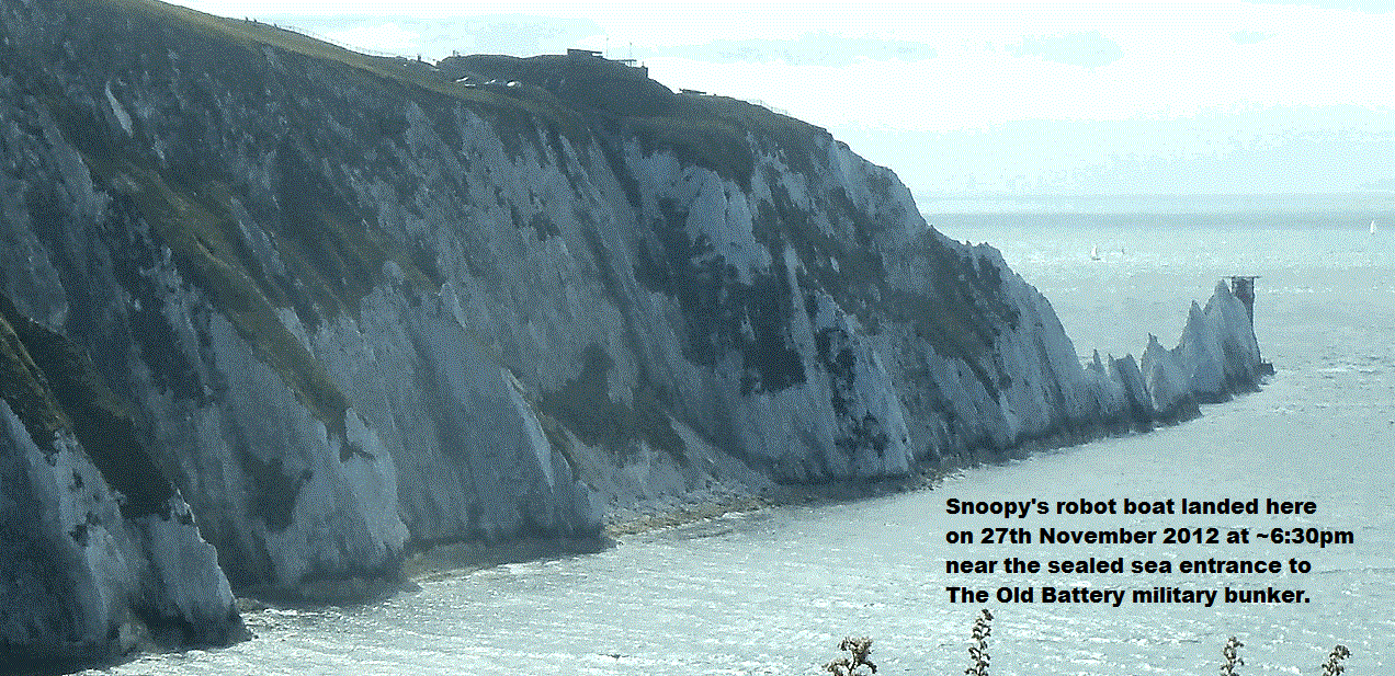
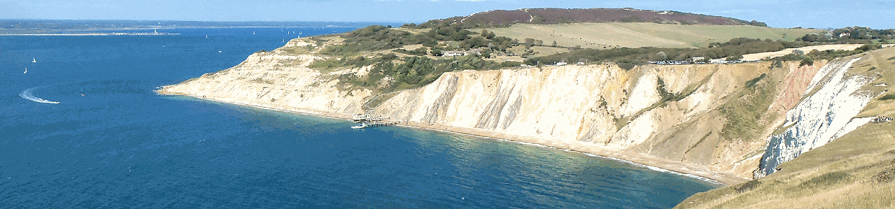
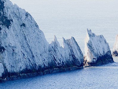
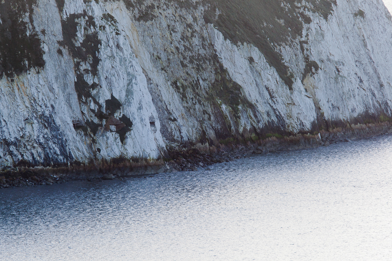
Robin and June were on the Isle of Wight for the start of Cowes Week, in August 2015. See the 4 minute Cowes Week 2015 video. They used the opportunity to visit a few places on the Isle of Wight, including The Old Battery near The Needles. These two pictures below were taken then. You can certainly see how close Snoopy's 2012 landing was to The Needles, and maybe, after his tracker stopped, and a few hours, days, or weeks, the tide did carry him past The Needles and south of the island. Even with that strong north wind, it is possible that "wind bending" due to the cliffs, kept Snoopy close to the shore, maybe taking him as far as Freshwater Bay. Maybe even Ventnor, claimed by someone who emailed Robin soon after, saying they had found the boat. Robin got many emails, including from far off places like Afghanistan, but it took weeks in 2012, before his "best guess" was made. See Snoopy's 2012 Atlantic Attempt :-)

 You probably reached this page from that called
GPS Guided Trans-Atlantic Robot Boat.
If not, you had better click on it and see what this page is all about.
We were hoping to find, fix, and re-launch Snoopy
before he is disqualified from this year's event !
Now, if found, it would be for next year's.
You probably reached this page from that called
GPS Guided Trans-Atlantic Robot Boat.
If not, you had better click on it and see what this page is all about.
We were hoping to find, fix, and re-launch Snoopy
before he is disqualified from this year's event !
Now, if found, it would be for next year's.
Our search priorities have changed, as time marches on and the wind has shifted.
The purpose of this page is to help others searching for Snoopy, to ensure their searches are done safely and efficiently, in the most probable places where he may still be, including allowing for where searches have already been done.
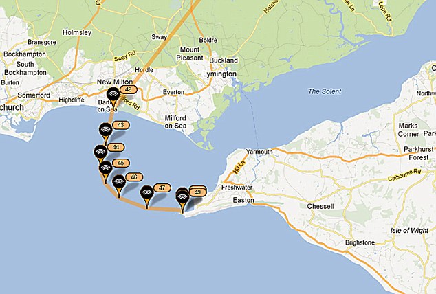
Where is Snoopy ? See details on the front page, but - in summary - winds shifted after that first two weeks, so now he might be found by beach-combers on the UK mainland, anywhere from Barton-on-Sea, past Hurst Castle, Lymington, or even as far as Lee-on-Solent.
The weather was good, and Winds kept Snoopy on that north coast for two weeks, but that may have changed.
No boat searches were done in two weeks, but if any do now: look for signs of where Snoopy visited, like bits knocked off, or even paint marks on the rocks. A camera is invaluable to show your search results to others. If and when there is a north winds, check for change of direction near The Old Battery.
Perhaps this page should be called "Peter's Page" because, right now,
by far the best information we have, is that from Peter's photo recce
and analysis, done within two days of Snoopy's last GPS position reports
on Tuesday evening.
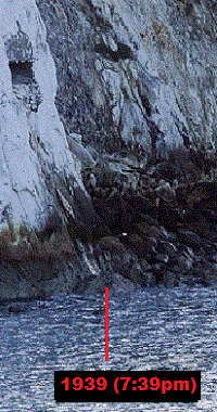
Above-right is Snoopy's last SPOT tracker GPS position report
marked on one of Peter's photos.
Peter is relaxed about his full name being public, and it already appears
under my "thankyou" section as:
"Peter Facey for his own time and expense, searching for Snoopy and those pictures to help others.
www.geograph.org.uk".
Anyone looking at the information below will realise how inadequate this "thankyou" is:
He has already analysed the large number of high resolution photographs he took on the Thursday,
including matching them up geographically with our GPS SPOT Tracker data, and looking carefully
for any signs of Snoopy, or gaps in cover - such as that entrance to the old military bunker !
It was also on his initiative, and at his expense, that he travelled by car and Ferry,
from and back to his home near Winchester.
How Peter has done his recce serves as an example to others on how we might best do more searching.
PLEASE DO NOT TAKE RISKS, TRYING TO FIND OR RETRIEVE SNOOPY !
These signs of Snoopy, and the photographs showing exactly where they were found,
compared with Peter's photos, should give us useful information on where he moved
after the last position reports near the entrance to the bunker.
If Snoopy is not found, after a thorough search of that north coast has been completed,
then this information may help us predict where he might have gone. e.g. if found
to the west of the bunker, that might indicate him having moved towards the Needles,
due to the northerly wind having been deflected to the west by the cliffs of Alum Bay.
He might then have managed to clear the Needles and be miles away, south.
Some parts, like the GPS Logger, hold useful data, such as his position every 15 minutes,
possibly after his last position report. They also reduce our need for spares.
See the section near the end of this page called
Here is a suggestion on how more searching might best be done (SAFELY!)
from a boat.
e.g. a two man team, one piloting the boat, and the other with a simple,
digital camera or camcorder, collecting overlapping photos or video frames,
to similar detail as these, to cover the whole area from The Needles to the
narrow entrance to the Solent near Hurst Castle, over 4 miles east.
This page should help them concentrate their search, particularly in the gaps
not yet covered. If they DO see Snoopy, they can obviously stop their search.
But even if they do not, their video or photos can be analysed later by
others or themselves.
We do not have the resources for this to be like a military operation,
but we can at least benifit from those with the right experience,
and/or local knowledge.
Finally: if there is one thing that would kill off
my enthusiasm for this project, including launching more attempts next year,
it would be someone getting hurt - or worse - in trying to find or recover Snoopy.
I don't want people taking risks, especially since it would be the most natural
thing in the World, to start with a boat search, at a safe distance from the
shoreline, and waves crashing on rocks - but then, having seen Snoopy - to be
tempted to go in much closer. So let me repeat:
Oh yes - it has been suggested that I be the person searching for Snoopy on a boat,
if and when one is available. My excuse is that I can be more use here,
updating these pages, and putting people in touch with one-another.
It is not that I cannot swim, or prefer to stay in the warm and dry ! :-)
I'm obviously at the stage of tidying-up, both this page, and the one that links to it.
Please forgive any typos or duplicated information.
Robin Lovelock
You can email me on
robin@gpss.co.uk, my home land-line is 01344 620775.
Mobile phones may be unreliable on the Island for voice, but you can text to my 07736 353 404.
Much of the following was moved from the page:
GPS Guided Trans-Atlantic Robot Boat.
PLEASE DO NOT TAKE RISKS TRYING TO SEE OR RESCUE SNOOPY!
You can enlarge the map by clicking on it, or clicking
here
The blank version of this crude map is
here as rbsearc.bmp
Typical colour use, other than black for coastline and grey for lat/lon grid and GPS track are:
An IoW Resident searched the corner of Alum Bay on 11th December but found nothing.
More information has been added, to help anybody searching by boat,
including how it is best done - SAFELY! This will exploit the excellent photo recce and analysis
performed by Peter, providing detailed coverage of Alum Bay, including where
Snoopy last reported - near the door to an old military bunker !
The page will continue to be updated, as more information comes to Robin.
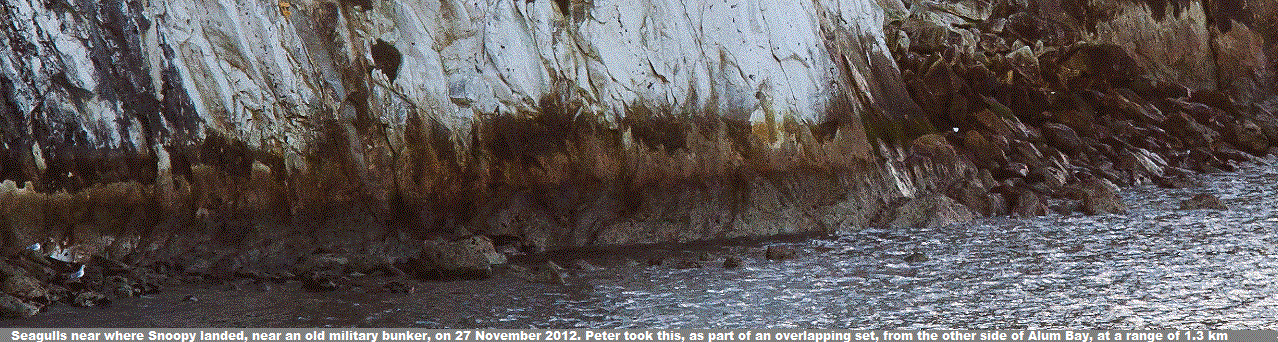
Those searching (SAFELY!) should see Peter's mosaic of pictures below, with
X marking from where Snoopy last reported, and
landmarks such as caves.
Binoculars or a telescope will be useful. A camera
will let you take a picture to send to me to show others.
Here are some recent calculations, based on wind and tide, that may help us
concentrate our search in the most likely area: from that spot you can see,
below the car park, to (far less likely) about 4.5 miles towards the narrow
gap between Hurst Castle and the Isle of Wight. My best guess is that
he is still in Alum Bay, tucked away in a crevise - or maybe a cave ?
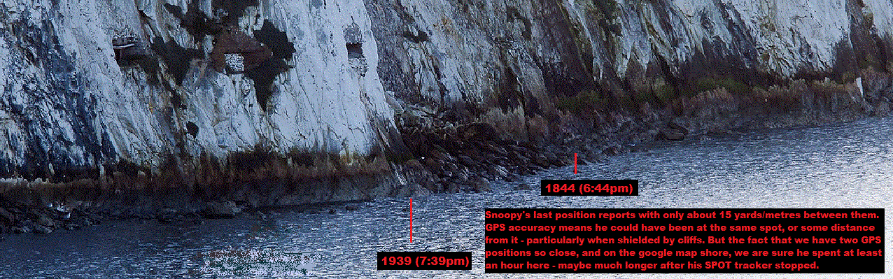
Snoopy spent over an hour at that spot, with the last two positions at 1844 and 1939
being seperated by roughly 20 yards/metres - and on the google map shoreline.
So that was his real position until after his last report at 1839.
At that time the tide was about 2 knots to the east, and it turned
westward at about 2200. So, that's how I calculated the 4.5 miles.
BUT - when you look at his path, pulled by the tide, including against
that wind from the north, it seems unlikely he would have travelled anywhere near that far.
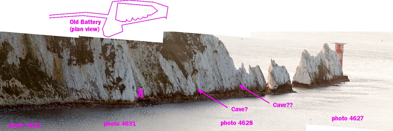
Here is Peters
picture 4631
showing the last two position reports. Snoopy checking out a military installation ?
See
Fortifications of the Isle of Wight - The Needles Old Battery.
Peter's map, showing the coverage of his photo recce. Note gap in corner of Bay, and spots such as caves.
Right now, of course, our problem is in having ANY boat search, while wind keeps Snoopy near that north coast, but our priorities are:
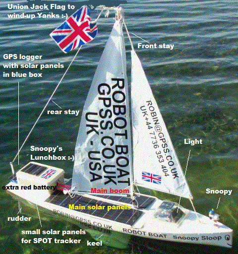
We are obviously looking for Snoopy, as a complete boat, including hull and sails,
but also for parts that might have been knocked off him, like the blue GPS logger
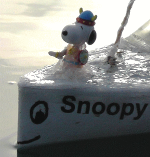
box at the back, and the solar light pyramid at the front. Maybe even Snoopy himself.
Even chips of white sealant or paint, that may have marked the rocks.
"last GPS data received from Snoopy's SPOT tracker, plus that for Wind and Tide ..."
where I present the latest known GPS, Wind and Tide data, that may have to be used
if we cannot find Snoopy in these searches.
how we might do the search ...
PLEASE DO NOT TAKE RISKS, TRYING TO FIND OR RETRIEVE SNOOPY !
- it's just not worth it !
 Please don't send Robin hoax emails, pretending to find the boat, as someone did Thursday afternoon.
Maybe we will tell you more about this chap in a few days, but we don't want to distract our searchers now.
If anyone does find Snoopy, Robin will want to speak on the 'phone urgently ;-) He will want to know your
full name,
'phone number, and if it is OK to put you in touch with the others helping to find and recover Snoopy, including the BBC.
If you don't want to be on Radio or TV, that's OK - but Robin needs to know.
Please don't send Robin hoax emails, pretending to find the boat, as someone did Thursday afternoon.
Maybe we will tell you more about this chap in a few days, but we don't want to distract our searchers now.
If anyone does find Snoopy, Robin will want to speak on the 'phone urgently ;-) He will want to know your
full name,
'phone number, and if it is OK to put you in touch with the others helping to find and recover Snoopy, including the BBC.
If you don't want to be on Radio or TV, that's OK - but Robin needs to know.
Map showing searches done ...
This map shows the areas of Isle of Wight (IoW) coast searched.
BLUE - Wind Direction - including speculated effect of cliffs, turning a north wind westward.
RED - areas not yet searched, or where Snoopy may be hidden. e.g. caves.
ORANGE - areas searched but where Snoopy may have been hidden - such as behind rocks.
YELLOW - areas searched, where unlikely to have missed him - well recorded by photos/video.
GREEN - areas well searched and very well recorded on photos/video.
Peter's search on 29th November 2012 ...
Readers may want to read this, and talk of the two Hotchkiss 6-pounder quick firing guns and a Maxim machine gun.
We hope that they hold fire during any close recce boat approaches, as they did when Snoopy visited ! :-)
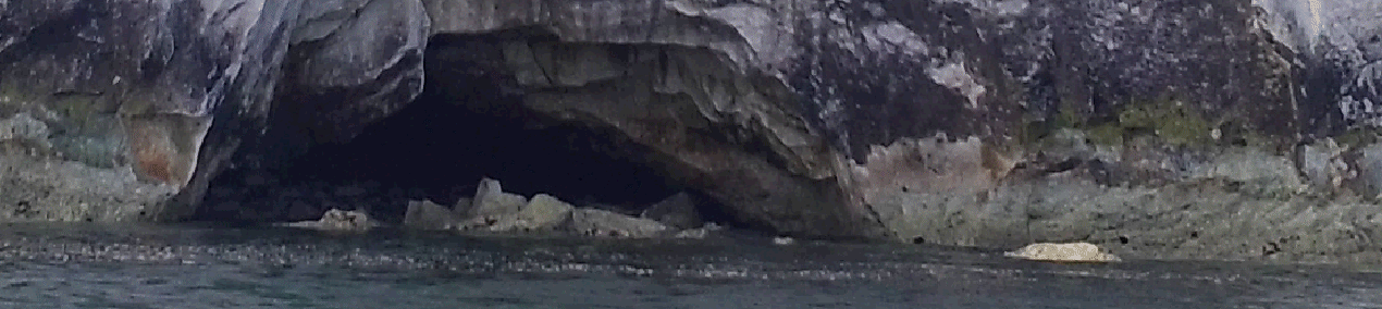
Thanks to the National Trust, who now own this site, we now know the only access to this spot is from the sea. Also that there IS a hidden area, extending about 5 yards back.
It would be good to have detailed photos of this hidden area, and from other angles. Bits may have dropped off Snoopy ?
Also pictures looking into any other inlets or caves.
Here is a mosaic of pictures, made by Peter, with X marking where Snoopy hit the rocks and spent over an hour - maybe much longer. Maybe he is hiding in one of those caves ? :-)
Here is a much more recent picture of one of those caves, taken on Saturday 6th July 2013, by someone else. Many Thanks Alex ! :-)
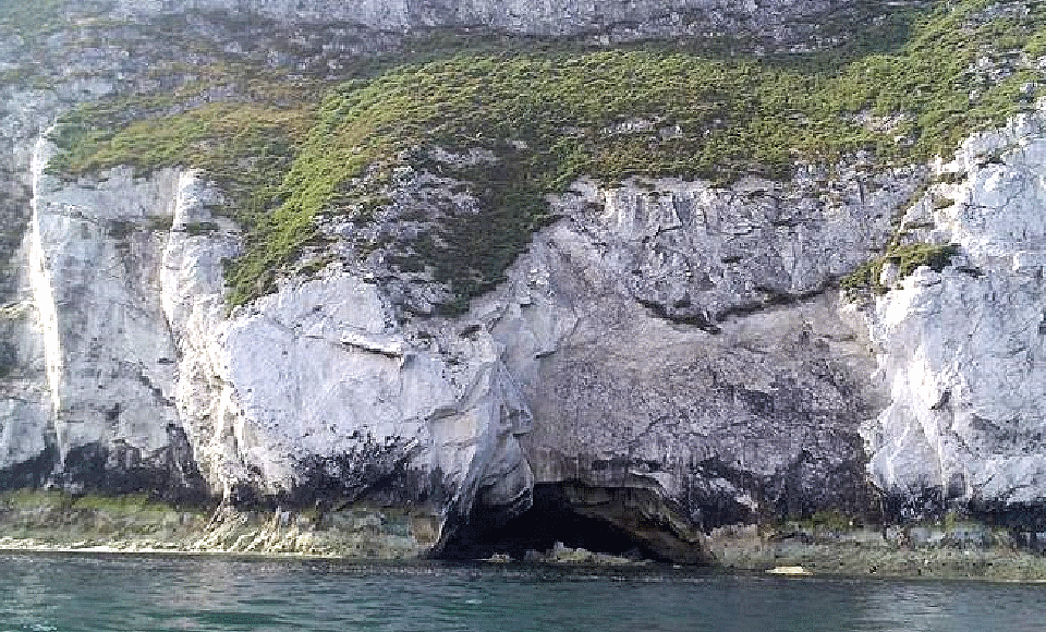
What's that to the right of the cave ? Snoopy Sloop 8 on it's side, deck facing us ? :-)
 Here is the eastern side of Alum Bay taken by Peter. He reports Snoopy was not to be seen.
Snoopy's solar white light should come on at dusk
- if it's not been smashed.
 If he'd drifted out (sheltered from wind by the cliff), after the tide turned,
he might have been taken west by the tide, past the needles, then blown out to sea.
This seems unlikely, but if he did, he might end up with the French - or Americans ? :-)
If he'd drifted out (sheltered from wind by the cliff), after the tide turned,
he might have been taken west by the tide, past the needles, then blown out to sea.
This seems unlikely, but if he did, he might end up with the French - or Americans ? :-)
Matt, and then Peter, looked across Alum Bay from The Needles Country Park, and down the cliff - where it was safe - from above the spot, on Tuesday night then Wednesday. Nothing was seen for sure.
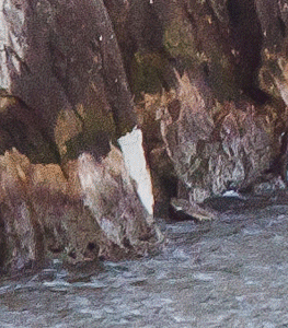
Chalk pretending to be Snoopy ? Peter sent Robin a lot of photographs like these, covering parts of Alum Bay. That looked like a sail, in the correct spot, but Peter thought it was probably just chalk coloured rock. At first we said here that it's certainly worth checking closer, but the next morning, Peter pointed out the picture (on right) that more clearly shows it was chalk, and not Snoopy's sail. Robin had said: "If it IS Snoopy's sail, then the spot transmissions might have stopped due to screening by the cliff. But don't let us be too optimistic, or relax our wider search along that north-facing coast". Well Done Peter - for all that effort, including travelling to and from your home on the mainland.
So no need for someone to take a closer look at that white patch with a telephoto lens !
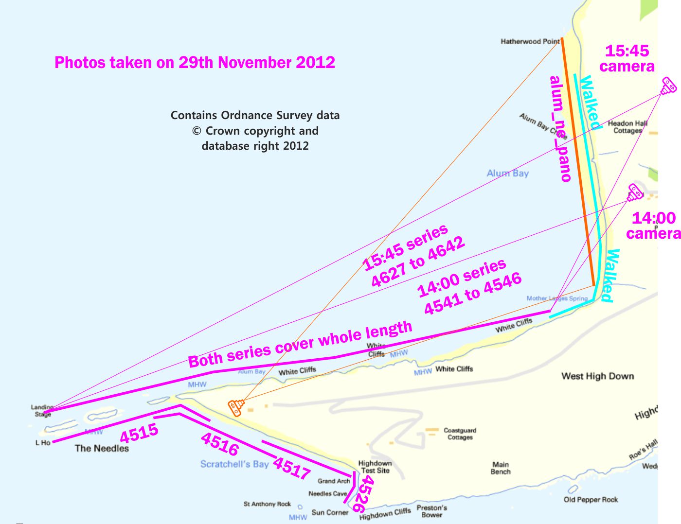
Robin has added the map provided by Peter, below, to show the coverage of his photo recce on an O.S. map.
For those checking the tide level, rather than direction, here is more info:
"The two series have their time of photographing on them (i.e. 14:00 and 15:45). The other photos were all taken earlier, e.g. before 14:00. Walking at Alum Bay NE was done after 15:45. As you say, from footpaths etc."
Here are extracts from Peter's emails received today.
Walked today along the IoW coast from 11:38 to 14:19, with low water being at 13:13.
See gps track attached. Parked in Colwell and walked SW as far as could along Totland Bay.
Then turned round and walked NE all the way to Fort Albert, directly opposite Hurst Castle. Then back to Colwell and the car.
Took a some photos but no real point in you studying them, as I surveyed the whole scene with the mark I eyeball and saw no Snoopy. Unlike Alum Bay, along this stretch of coast one can see everything from the beach so, IMHO, no need now to survey this part by boat. In addition, much of this (except for the extreme SW and NE ends of my walk) is walked regularly by people with dogs and I guess they�d have seen Snoopy if he was there.
I�ll send a few low res photos in next email, so you can see what the foreshore looks like.
Some low res photos attached.
Rocks near Fort Albert are very large. I have clambered over them a bit and didn�t see Snoopy but cannot be absolutely certain he isn�t stuck in a crevice there. But I think it unlikely.
I have looked at the
foot of all the sea walls along that walk, and looked both sides of all the
groynes. And sadly nothing there.
It seems the most likely sighting will be from a boat, by people like Matt
who know how to do it safely, and are familiar with this stretch of dangerous coastline.
It is possible that Snoopy is hiding in a cave, or some nook or cranny not seen from the shore.
Compare what you see with his photographs, in case bits have been knocked off,
and may be nearby, such as the solar light pyramid at front, blue GPS logger at the back,
and - of course - Snoopy the Viking at the front ! :-)
If that big plastic box at the back is broken, or the lid has come off,
try not to let the contents be lost - although we have spares for almost everything -
including a clone of Snoopy !
If the strings to the top of the mast are still OK, it should be possible to lift
him from there. The rudder, and the main sail boom joint, are the only relatively delicate parts.
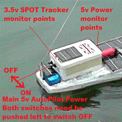
You should switch both those big switches at the back, to the left, and OFF.
If the Autopilot were still working, switching ON gives a left-centre-right-centre test movement.
But I'm expecting we will need time fixing him, even if it is hours rather than days.
If we can get him back to the warm and dry, such as your home, office, BBC offices,
or one of my friend's place, then we can fix up a skype connection so we can assess damage
in detail. This will enable me to check I have all the required spares here ready.
This is part of a phase of operations: Finding, Retrieving, Damage Assessing, Fixing, Re-launching.
The first damage assessment is pretty obvious, and can be done by those finding him: bits missing or broken.
If we are in the very lucky position of no significant damage to his electronics - seen
by visual inspection, including for water ingress, and lack of flashing LED lights,
we can think of checking the voltages of his batteries.
A simple volt-meter, such as can be got for as little as �5, or many people into electronics will have,
can be used to check two sets of voltage: At the front of Snoopy's Lunchbox, there are two test points,
where the main solar panels connect in to the main 5v power used by the Autopilot.
At the rear of the box there are two monitor points for the 3.5v power used by the SPOT tracker.
After many days out of the sun (under those cliffs) the voltages will drop,
and the batteries will need to be recharged - by the right equipment, and following
the correct procedure. This should only be done by those in contact with Robin
- as was done by the BBC's "Dr Bottle" during last year's
BBC GPS Bottles operation.
Robin can put more information and pictures here soon, as they are needed.
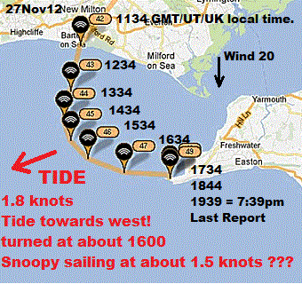
Snoopy was launched at 1130am Tuesday, but a strong tide pulled him into Alum Bay, Isle of Wight.
He last reported on the rocks at 1939 (7:39pm) in Alum Bay.
He then stopped reporting - water in electronics ?
Snoopy may have sailed over 5000 miles on Bray Lake this year, in winds over 50mph, but strong tides
and hard rocks are something else ! :-)
Play the BBC TV South video of Snoopy's launch filmed by reporter Ben Moore
here.
For more information, please see
GPS Guided Trans-Atlantic Robot Boat.
Snoopy's track is on the
Microtransat Live Map.
The
Map
above is from the
Mail Online.
* You can see what winds to expect by looking at UK Winds.
Robin has a theory that the cliffs around the bay may convert a north wind into an east wind,
and blow the boat west, towards the Needles - even when the tide is trying to push the boat eastward.
This is discussed technically below - but don't worry - this is not a very technical test :-)
What do you need ? One or more party balloons and a digital camera. No need to blow them up with helium - your own
breath will do. If they are white, or a bright colour, you should see them for the half mile, across the bay.
You will also need an ordinary digital camera or camcorder. This will time-stamp any still photographs
or video you shoot, to capture the balloon being blown the few minutes across the bay, across the surface of the water.
The images of the balloon against features of the peninsula, and the time stamps,
will enable the approximate speed to be calculated - but you will probably see
any obvious change in direction: away from you towards the cliffs south of you,
then starting to move westward, faster and faster, as the balloon gets within
maybe 100 or 200 yards of the north-facing shore.
This information could be very important in us explaining Snoopy's movements
on Tuesday, where he might of gone if he is not found soon, and what to
expect when he is re-launched, in the same boat or another.
More detail on this is below, in the section discussing GPS data, wind and tide.
The quickest way of my getting this idea to the public, and others who may be able to help,
is to copy my email reply to a chap who 'phoned me on my mobile while we were having an italian
class at a friend's home, then kindly made email contact with me.
I'm sure he and others
referred to by first names only, will not mind me doing so: they will know who they are,
but I'm sure nobody else does :-)
Maybe you are interested in doing this very soon, while we may still find Snoopy,
or bits that may have been knocked off him ?
If so, please contact me by email.
Here is my email reply to Dick (with pictures added, and links made hot) ...
Hi Dick - that was a nice interruption tonight - I ducked out of italian class a few minutes
Let me CC a couple of very local friends, one of whom has done aerial recce (video) with me
years ago, and the other has pointed me to these tupes of product, with GPS capability.
But right now, as you know, my time is spent on www.gpss.co.uk/autop.htm
and the linked page showing results from photo recce done so far.
The most efficient way of me doing things is simply to put people in contact
with each other and share relevant information. The web page is the main means,
and the Press - particularly BBC TV South and Radio Solent, the main means
of reaching new contacts among the public.
This is an interesting idea, but the only way I see it working is either an enthusiast,
or more likely a business wanting some free publicity, to try some aerial recce soon,
and entirely at their own cost and risk (hopefully only equipment loss).
I may put a small section for "bright ideas" such as this on that page tomorrow.
What you describe might be done very effectively from the cliff tops,
but the problem is that each day that ticks by, the wind may change,
blowing the boat, or what remains of it, away from that stretch of coast,
widening the search area, or making searching rather pointless.
It's very analogous to that GPS Bottles project you will see linked from the page.
So if anyone does it, I'd hope for the recce pictures/video to be made available
to others, rather than people simply claiming they have searched an area without a find.
e.g. for Peter, we can scan the shoreline images ourselves (he's obviously done it)
and note patches, however small, not covered. e.g. the corner of Alum Bay or
that 5 metre slope hidden behind the rock, at the entrance to the old military bunker.
I'll also CC this to Peter for his interest.
If you can find people interested, I'll be glad to put up more info and speak to them.
The GPS control possible with some of these systems is interesting,
particularly if it permits operation out of line-of-sight and radio comms.
No need for VR goggles - just have a small video camera - as we had on Bray Lake.
It makes video based searching possible over wider areas than we had considered.
Oh yes, Stuart did try my Snoopy autopilot on his 'plane - briefly - a few months ago
But the key will be to motivate people to do this quickly enough - maybe you can do that ?
Many Thanks
If you click
on the picture on the right, you will see the GPS track of the GPS bottle, launched by the BBC in 2011.
This track agrees with Robin's tidal current data. i.e. when the tide turned, in what
direction, and at what speed, did it flow near those positions and times.
Robin was interested in the direction and speed of tidal current: not the height of the tide.
Robin noticed recently that his tidal current data does not match up with the movement of Snoopy.
More about all this soon, after we've spoken to a few more people and analysed the information we have.
e.g. after being "caught", Snoopy was being carried at about 1.5 knots.
What sails at 1.5 knots ? A sea kayak with Snoopy ? :-) It would only have taken 30 minutes
from Alum Bay or Freshwater, with the tide, to reach Snoopy - but bringing him back must have been something else !
Finally: if you know who it was, please show them this page.
Whatever they did, will not be a problem for them - in fact quite the reverse ! :-)
Please see
Snoopy needs YOU !
above. The tidal current data below is probably correct !
However, it might still be useful, if it is easily available,
to have similar wind data, between the UK and French coast,
to guess better where Snoopy may have landed - if he DID make
it out past the Needles.
This was not so much a "bright idea" as a request to anyone who might provide
me with data, on the direction and strengths of wind and tide, at Snoopy's
hourly position reports, from launch at Barton on Sea, at 1130 GMT on Tuesday 27th November
2012, until his last report that evening, on the rocks near the old military bunker.
We have that now.
Our first priority was the search for Snoopy,
or at least signs of what happened to him, like bits being knocked off by the rocks, marking his path.
Before a second attempt, which could have been in days, or next year, I wanted to have
made good use of the data we have, to explain his movement, and choose a suitable
time and place for re-launch.
If we don't find Snoopy, then another boat will be built, and Snoopy will try again in 2013.
Maybe, I can try and use the wind and tide data we get, to do similar "informed guesses" on where Snoopy might
eventually arrive. e.g. if he was blown back out west of The Needles, and then south, maybe he
could be a long way away now. The wind may then be the main factor, together with the state of Snoopy's boat:
For weeks, my opinion was no different from the fears expressed and published before launch,
on the front page heading, "Launch before Christmas...". e.g. "We fear our simple GPS autopilot may be confused by the effect of tide".
But then I got the UKHO data, saw that my original tidal data was correct, and that Snoopy probably
moved east, onto the Needles, because he had been "snatched".
Snoopy's GPS track for the first two hours, shows a good straight line, and remarkably close to the
exact direction to that first waypoint, 33 miles out to sea. He sailed an actual course of 192 degrees,
just 6 degrees off from the waypoint at 186 degrees. This was in a tide of about 1 knot.
That 6 degree error is fine,
because the autopilot recalculates the heading to steer every few seconds.
It seems that, after Snoopy was "snatched", he was taken (in a kayak?) back towards the car park at Alum Bay,
but then released, perhaps about 200 yards from the shore, some time after his 1734 position report.
This is less important now, since his position on the rocks could be explained simply from his time of release.
Also: I don't plan Snoopy to visit that military bunker again in the near future :-)
A more detailed check on those winds - and particularly tide, directions and speeds,
will enable me to analyse what happened in more detail, and plan better our next launch,
in terms of exact time and place of launch.
It's also possible that, if Snoopy is not found after a good search along that north coast,
this data may reveal where he went. e.g. west, and out through the Needles,
even though that does not yet seem probable.
We have three sets of data:
Snoopy's
Track on Google Earth can be used to read out distances and directions for each leg.
The position at 12:34, an hour after launch is particularly interesting, since he does not change
direction, despite the moderate tide of between 0.7 and 2.2 knots. 1 knot ? Also we can see
that he has covered about 1.75 miles (1.5 NM), so has sailed at about 1.75mph (1.5 knots).
Speeds here are in knots, and direction in degrees clockwise from north. e.g. 0 degrees = wind from north, 45 = wind from north-east.
Here is the GPS data, first positions first, from Robin's Microtransat account. More clarification later:
Here is wind data on the Hurst Castle website found by Peter:
www.weather-file.com/hurst/
and below is data from it I've extracted for those hours when Snoopy approached the rocks then stopped reporting.
In summary, we can see that the wind remained in a direction about 350 (from NNW) at a speed of about 20 knots.
The above was published in 2012, and that below was added in October 2013 ...
footnote added 5th November 2013:
Many Thanks to an "old Met Office Friend" who provided this data below.
It seems to confirm Peter's data above, and earlier conclusions, below the data, written in October 2013.
The wind direction at 1234 is of particular interest: 14 - when Snoopy was halfway along that perfectly straight
part of his trip. The above numbers are direction wind is coming FROM, so add 180 before comparison with this.
e.g. at 1234, compare 187 with 180+14. i.e. only 194-187 = 7 degrees different. i.e. sailing directly downwind.
Snoopy's pattern of movement changed after 1334, to move towards the east, against the tide, which gradually decreased in strength.
By 1534, Snoopy was in the middle of this new path towards The Needles. Google Earth shows his direction to the distant waypoint
not being very different: 189 degrees. Comparison with the wind shows a 11 degree difference. i.e. still close to sailing directly downwind.
See "Conclusions..." in
October 2013 Atlantic Attempt.
The source data is here as
RBWIND12.CSV.
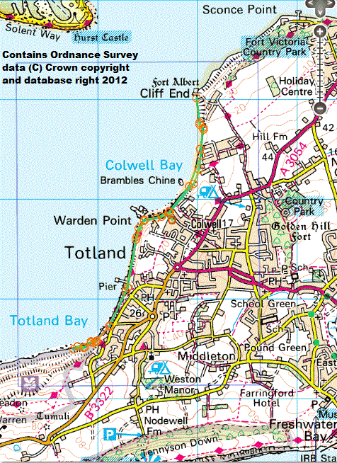
Totland Bay, north to Cliff End, opposite Hurst Castle, searched today by Peter.
No change to our best guess at where Snoopy is, or our priorities.
Key:
4717 extreme SW end of walk. Hatherwood Point is about 1.5 Km beyond here along coastline no easily walked.
4726 Totland Bay looking NE towards pier.
4730 Rock groynes looking NE approaching Warden Point
4748 Warden Ledge (with Hurst Castle and Fort Albert on horizon)
4755 Fort Albert seen across Colwell Bay
4758 Approaching Fort Albert looking NE
4764 Massive concrete bolders near Fort Albert (with Hurst Castle on horizon)
4766 Foreshore approaching Fort Albert looking NE
4773 Fort Albert (with Hurst Castle on horizon)
If anyone gets (SAFELY!) to Snoopy - probably by boat ...
 It is still possible that the first sighting of Snoopy will be from the land,
with someone armed with little more than binoculars. It would be a miracle
if he washed up on a beach, or rocks, where it was safe to fetch him.
It is still possible that the first sighting of Snoopy will be from the land,
with someone armed with little more than binoculars. It would be a miracle
if he washed up on a beach, or rocks, where it was safe to fetch him.
 If he is reached (SAFELY!), contacting me as above still applies, but here is some additional information:
If and when we get Snoopy into someone's home or office ...
Earlier recent News about Snoopy and links to BBC TV News videos, etc ...
Snoopy's last position on Google Maps
was at 7:39pm Tuesday 27th, near a military bunker in Alum Bay.
Party balloons across Alum Bay ? Testing effect of the cliffs on wind direction ...
 This may sound rather crazy: a simple test, possible only when the wind is blowing from the north*,
is to release one or more ordinary party balloons from the north end of Alum Bay, and see
what they do when they get near the cliffs on the north-facing edge of the bay.
This may sound rather crazy: a simple test, possible only when the wind is blowing from the north*,
is to release one or more ordinary party balloons from the north end of Alum Bay, and see
what they do when they get near the cliffs on the north-facing edge of the bay.
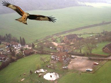
Bright Ideas - such as use of radio control Quadrocopters ...
 To see what we were playing with years ago, before the technology for airborne video
was so cheap (�7 to �20 for keyring camera instead of wireless TV camera)
See
www.gpss.co.uk/tam.htm
and linked pages such as filming the
Red Kites
in the Chilterns
(you will see Stuart, and Stuart's 'plane, in some of these videos)
To see what we were playing with years ago, before the technology for airborne video
was so cheap (�7 to �20 for keyring camera instead of wireless TV camera)
See
www.gpss.co.uk/tam.htm
and linked pages such as filming the
Red Kites
in the Chilterns
(you will see Stuart, and Stuart's 'plane, in some of these videos)
 If you read what I've put today on the linked "Searching for Snoopy" page
you will see I'm talking about boat searches providing overlapping photos
or - maybe more practical - video, to a resolution able to recognise a seagull
- as we have already from Peter, using his land based camera.
If you read what I've put today on the linked "Searching for Snoopy" page
you will see I'm talking about boat searches providing overlapping photos
or - maybe more practical - video, to a resolution able to recognise a seagull
- as we have already from Peter, using his land based camera.
Robin
www.gpss.co.uk
2220 Mon 3 Dec
Snoopy needs YOU !
When did the Tide Turn ?
Why is this so important ? There are two reasons:
1. the next launch of Snoopy should be at a time when "the tide is right". Robin thought it WAS right on the 27th !
2. if Robin's data WAS correct, then Snoopy was "stolen" by a passing boat that Tuesday afternoon ! :-)
 Footnote from Robin:
first an important message to the sailor who "stole" Snoopy at about 2pm that fateful Tuesday 27th November.
Don't worry - you must know by now, from these pages, that I do have a sense of humour ! :-)
But, even if Snoopy is now lost, it would be good to know for sure, what happened.
Unexplained things might delay Snoopy's next boat being dropped into the sea again early next year.
I'm very grateful to Chris at the UKHO, who sent me detailed tidal current data by email.
The result was so dramatic that I had to 'phone Chris back immediately, to make sure I'd not misunderstood it.
THE TIDE WAS FLOWING TOWARDS THE WEST when Snoopy appeared to be dragged to the east, onto the Needles.
There are many other implications - all good - for this latest information. e.g. that "design limitation"
of Snoopy being "confused" by the tide, may not be a limitation at all.
Footnote from Robin:
first an important message to the sailor who "stole" Snoopy at about 2pm that fateful Tuesday 27th November.
Don't worry - you must know by now, from these pages, that I do have a sense of humour ! :-)
But, even if Snoopy is now lost, it would be good to know for sure, what happened.
Unexplained things might delay Snoopy's next boat being dropped into the sea again early next year.
I'm very grateful to Chris at the UKHO, who sent me detailed tidal current data by email.
The result was so dramatic that I had to 'phone Chris back immediately, to make sure I'd not misunderstood it.
THE TIDE WAS FLOWING TOWARDS THE WEST when Snoopy appeared to be dragged to the east, onto the Needles.
There are many other implications - all good - for this latest information. e.g. that "design limitation"
of Snoopy being "confused" by the tide, may not be a limitation at all.
Bright Ideas - data on Tidal Current and Winds ...
Also, Robin does now have good tidal data, from Chris at the UKHO.
 The academics among you may want to click on this picture from my DRIFT model, to the page where it was first used years ago.
If you read that page, you will see that our tests on Bray Lake, then the sea, gave us 3% of wind speed, in direction of wind,
to put in the DRIFT model. These movement is added to the greater, but cyclic, movement due to the tide.
The academics among you may want to click on this picture from my DRIFT model, to the page where it was first used years ago.
If you read that page, you will see that our tests on Bray Lake, then the sea, gave us 3% of wind speed, in direction of wind,
to put in the DRIFT model. These movement is added to the greater, but cyclic, movement due to the tide.
Note that, right now, until a thorough search is completed, Snoopy is probably on that north coast of the IoW.
if drifting at 3%, with northerly winds, maybe by now (6th December) he has reached the Normandy north coast ?
- but only IF he had been pushed west, out of Alum Bay, and past The Needles.
- at about 3mph/knots ?
- with winds as they have been, very favourable, he might have made 3 knots towards the Start Line, and now be heading south ?
If so, and if all his systems continued to work (sadly, without the spot tracker) he might sail in to his USA destinaton
as early as March or April ! :-)
Also, those "crude guesses" above are not based on good wind data, or knowledge of what state Snoopy is in.
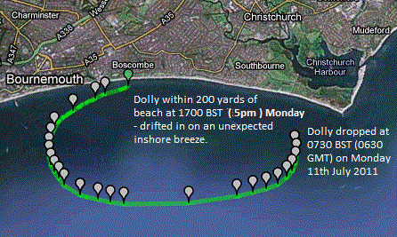
The picture on the right is from the
BBC GPS Bottles page, and shows the actual GPS track of GPS bottle Dolly Dorset in 2011,
showing extent of east-west drift due to a cycle of the tide, over 9.5 hours. This GPS track,
and earlier ones, agreed well with our DRIFT model. But we don't need to use the DRIFT model
to get useful information from it: that cycle of the tide may tell us the distance
margin (how far west along the beach to launch, to miss The Needles or Studland Bay)
if we were to launch at any time. However, we would be silly not to check the expected tidal current for the planned launch,
as we would the wind direction - which is even more important - not easy to tack near the shore!
 At first I was interested in why Snoopy suddenly turned south, before he hit the rocks.
I assumed wind funnelling, caused by the cliffs, changing a north wind
into a stronger local east wind.
At first I was interested in why Snoopy suddenly turned south, before he hit the rocks.
I assumed wind funnelling, caused by the cliffs, changing a north wind
into a stronger local east wind.
last GPS data received from Snoopy's SPOT tracker, plus that for Wind and Tide ...
All this data could be improved, including wind direction measurement within 300 metres
of the bunker, to get a better idea of the effects of the cliffs.
e.g. changing a northerly wind into a easterly wind.
All data is for Tuesday. i.e. 11/27/2012. e.g. Wind from north at 17 knots = 17 @ 0.
e.g. Tide to West at 0.7 knots = 0.7 @ 270
Spot tracking data (last GPS position report appears first) and that for Wind and Tide:
Time        Latitude  Longitude  Wind      Tide
9:00 PM                          17 @ 0
8:40 (no report from SPOT tracker)
8:00 PM                          27 @ 10
7:39:39 PM 50.66344  -1.58286 Near Old military bunker (last report)
7:00 PM                          22 @ 10   2.2 @ 090 ?
6:44:12 PM 50.66332  -1.58304 On rocks near Old military bunker
6:00 PM                          21 @ 0    2.4 @ 090 ?
5:34:11 PM 50.66517  -1.58252 250 yards north of rocks
5:00 PM                          20 @ 0    2.0 @ 090 ?
4:34:11 PM 50.66650  -1.62094
4:00 PM                          20 @ 0    0.4 @ 090 ?
3:34:27 PM 50.67400  -1.65131
3:00 PM                          18 *      1.2 @ 270 ?
2:34:05 PM 50.68332  -1.66583
2:00 PM                          13 *      2.0 @ 270 ?
1:34:26 PM 50.69420  -1.67163
1:00 PM                          12 *      1.0 @ 270 ?
12:34 PM   50.70953  -1.66583              1.0 @ 270 ? about 1.75 miles south, an hour after launch
12:00 PM                         7  *      0.7 @ 270 ?    * added here in October 2013
11:34 AM   50.73399  -1.65784 Barton-on-Sea beach launch at 1130.
Snoopy
Lat,Lon,Time,Unixtime,ElapsedTime,Distance,TimeDiff,Speed,CumulativeDistance
50.7339900,-1.6578400,2012-11-27 11:34:15,1354016055,0,0,,,0
50.7095300,-1.6658300,2012-11-27 12:35:28,1354019728,1.0202777777778,2.7756345159437,3673,2.7204694411645,2.7756345159437
50.6942000,-1.6716300,2012-11-27 13:34:52,1354023292,2.0102777777778,1.7517746452728,3564,1.7694693386594,4.5274091612165
50.6833200,-1.6658300,2012-11-27 14:35:16,1354026916,3.0169444444444,1.2761318540236,3624,1.2676806496923,5.8035410152401
50.6740000,-1.6513100,2012-11-27 15:34:39,1354030479,4.0066666666667,1.455350809895,3563,1.4704639112046,7.2588918251351
50.6665000,-1.6209400,2012-11-27 16:35:03,1354034103,5.0133333333333,2.2955732639712,3624,2.2803707920244,9.5544650891063
50.6651700,-1.5825200,2012-11-27 17:35:27,1354037727,6.02,2.7101758156552,3624,2.6922276314455,12.264640904761
50.6633200,-1.5830400,2012-11-27 18:44:56,1354041896,7.1780555555556,0.20881890714453,4169,0.18031855738074,12.473459811906
50.6634400,-1.5828600,2012-11-27 19:41:19,1354045279,8.1177777777778,0.018400605289172,3383,0.01958089832723,12.491860417195
this will be used soon, to update the information above.
Date Time Backed Avg Wind Direction Veered Min Wind Speed(Knots) Avg Wind Speed(Knots) Max Wind Speed(Knots)
2012/11/27 23:50.00 359 17 45 5.54 17.37 23.91
2012/11/27 23:00.00 354 14 58 8.4 17.16 25.41
2012/11/27 22:00.00 354 16 51 10.36 17.2 22.88
2012/11/27 21:00.00 348 16 49 4.8 18.55 26.63
2012/11/27 20:00.00 348 14 56 6.2 20.65 31.12
2012/11/27 19:00.00 340 13 64 8.9 20.56 33.12
2012/11/27 18:00.00 340 14 35 11.57 19.68 33.63
2012/11/27 17:00.00 353 16 44 8.32 21.25 33.75
date,time,back_twd,avg_twd,veer_twd,min_tws,avg_tws,max_tws,avg_Pressure,avg_humidity,avg_temperature,avg_dewpoint,avg_volt,sampleSize *
2012/11/27,16:00.00,351,16,62,8.11,19.43,29.82,1004.8,76.2,8.4,4.5,11.8,527 *
2012/11/27,15:00.00,262,18,101,2.47,19.21,34.48,1003.9,81.2,8.3,5.3,11.8,505 *
2012/11/27,14:00.00,334,13,125,4.7,20.94,34.48,1003.1,79.3,8.8,5.4,11.9,476 *
2012/11/27,13:00.00,293,12,64,4.32,18.69,29.99,1002.9,86.8,8.3,6.3,13.4,275 *
2012/11/27,12:30.00,309,14,102,2.59,14.7,23.0,1002.7,83.8,8.8,6.3,13.1,471 *
2012/11/27,12:40.00,345,14,55,6.65,16.35,31.41,1002.9,85.2,8.6,6.2,13.2,460 *
2012/11/27,12:00.00,350,7,74,2.66,16.45,24.98,1002.5,86.7,8.6,6.5,12.8,381 *
* footnote added in October 2013:
Directly above is data, found recently by Peter, that fills the gap for those first few hours of wind direction.
This is now of interest in comparing the behaviour of Snoopy's boat this year, and last year.
e.g. direction of wind in 2012, compared with direction of the destination of 187. This is discussed in the "Conclusions..."
in the page that describes the
October 2013 Atlantic Attempt.
"...  Needles, St Catherine's Point, Hurn (which is inland) and Portland.
Below are the obs from all those sites in that order in the format ddd/ff
where ddd is the wind direction in degrees and ff is the wind speed (or force) in metres per second.
Roughly, 1m/s = 2knots. Remember that the wind direction is the direction the wind blows FROM not TO ..."
11am      000/8.2    300/1.5    000/5.7    000/5.1
12noon   000/8.7    310/4.6    000/6.2    000/7.7
1pm        010/9.3    300/4.6    000/6.2    010/8.7
2pm        010/9.8    020/2.6    000/7.7    020/8.7
3pm        000/10.3  270/2.6    000/7.2    010/10.3
"... best estimate of the wind direction at Barton-on-Sea is northerly (000)
or just a touch east of northerly (010)"
We hope we've interpreted it correctly ! :-)