Home . About . GPS . Downloads . Business . Partners . Contact . Family . AVL . Links . History . AsOnTV . Forum
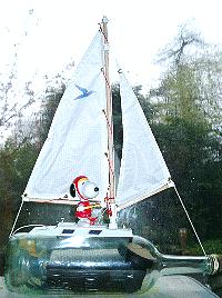
 I set up this page in early 2008, when I started this crazy hobby project: developing a small robot boat, capable of sailing itself
across the Atlantic, from UK to USA.
If you want to know more about me, our family, or my earlier defence systems career, then GPS software business,
you can start by clicking on my picture on the left, or
here. I'm Robin Lovelock, and the Press have described me as a "retired NATO scientist".
My wife June says that I retired 10 years ago !
I set up this page in early 2008, when I started this crazy hobby project: developing a small robot boat, capable of sailing itself
across the Atlantic, from UK to USA.
If you want to know more about me, our family, or my earlier defence systems career, then GPS software business,
you can start by clicking on my picture on the left, or
here. I'm Robin Lovelock, and the Press have described me as a "retired NATO scientist".
My wife June says that I retired 10 years ago !
 After browsing this page
and others, you can form your own opinion on myself and this rather challenging project. My local friend John told me about
the friendly Microtransat international competition, and I was soon hooked. I believe it was
the French who first suggested the idea years ago, and their attempts fired my enthusiasm.
That's the ENSTA Bretagne boat on the right and at the very top of this page.
Click on this picture for the 2012 teams - both with very small boats.
Other teams have tried, but all
these heroic attempts only survived a few days or a few hundred miles.
A journalist pointed out to me that Snoopy had already sailed over 5,000 miles, during our reliability testing of him on Bray Lake
in 2012. Snoopy has done a lot more sailing since then,
and that's why I am confident Snoopy has as much chance as the other teams ! :-)
After browsing this page
and others, you can form your own opinion on myself and this rather challenging project. My local friend John told me about
the friendly Microtransat international competition, and I was soon hooked. I believe it was
the French who first suggested the idea years ago, and their attempts fired my enthusiasm.
That's the ENSTA Bretagne boat on the right and at the very top of this page.
Click on this picture for the 2012 teams - both with very small boats.
Other teams have tried, but all
these heroic attempts only survived a few days or a few hundred miles.
A journalist pointed out to me that Snoopy had already sailed over 5,000 miles, during our reliability testing of him on Bray Lake
in 2012. Snoopy has done a lot more sailing since then,
and that's why I am confident Snoopy has as much chance as the other teams ! :-)
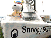
 You will find links below to more detailed pages, amusing TV broadcasts, newspaper articles, and home videos, of Snoopy's attempts
on the Atlantic since November 2012. This last attempt, in October 2013, seems much as we feared might happen in 2012,
with Snoopy being "swept by the tide". However, we were delighted to get him back, so he can try again soon.
You will find links below to more detailed pages, amusing TV broadcasts, newspaper articles, and home videos, of Snoopy's attempts
on the Atlantic since November 2012. This last attempt, in October 2013, seems much as we feared might happen in 2012,
with Snoopy being "swept by the tide". However, we were delighted to get him back, so he can try again soon.
 The November 2012 attempt was VERY different, and MUCH more "interesting" ! :-)
Maybe you can help in discovering who "snatched" Snoopy, or where Snoopy went after his time near that military bunker ?
Don't fail to watch those videos of our attempts to "beat the surf" in March 2013: now we know how to do it - with Magic Seaweed ;-)
The November 2012 attempt was VERY different, and MUCH more "interesting" ! :-)
Maybe you can help in discovering who "snatched" Snoopy, or where Snoopy went after his time near that military bunker ?
Don't fail to watch those videos of our attempts to "beat the surf" in March 2013: now we know how to do it - with Magic Seaweed ;-)
![]() I give this page a "tidy-up" when I can, moving material onto other linked pages. Over the years I've found it valuable,
despite it's limitations, to save everybody's time, when chatting to me directly: I am a very slow email typer ! These pages should be
of help to all in contact with me, including journalists and friends helping, both near me in UK, and in far off countries.
Many of my friends now providing invaluable help, first made contact with me after seeing the BBC TV South broadcast,
or a Newspaper article. Thank you everybody ! :-)
I give this page a "tidy-up" when I can, moving material onto other linked pages. Over the years I've found it valuable,
despite it's limitations, to save everybody's time, when chatting to me directly: I am a very slow email typer ! These pages should be
of help to all in contact with me, including journalists and friends helping, both near me in UK, and in far off countries.
Many of my friends now providing invaluable help, first made contact with me after seeing the BBC TV South broadcast,
or a Newspaper article. Thank you everybody ! :-)
 Sometimes I get questions that I've had many times before. I am a slow typer, so these questions and answers are often from my emails ...
Don't forget that "winning" Microtransat is not what this is all about for me: Microtransat is what inspired me, from years ago - particularly other team's failures. My challenge is to sail from UK to USA coast, but I may as well comply with Microtransat. Every attempt we make teaches us something, and a simple solution to a problem. e.g. in November 2012, in that first two hours of straight line to the waypoint, we saw the tide could be overcome, sufficiently well to get away. What happened after, taught us all to keep a close eye on the boat ! Then in March 2013, we could not even get away, past the surf. The solution was easy - choose a day with FLAT conditions, by watching the MagicSeaweed web site ! We also had our telescopic pole - just in case Snoopy tried to come in again. In October 2013, when Snoopy WAS simply swept by the tide, we eventually found that it was probably simply due to a screw coming loose on the rudder linkage. The answer was also simple: use Loctite! Also, do lots of Bray Lake Tests, to check the behaviour of the boat, before 24/7 reliability tests.
 Most of the other teams don't have much choice, because their boats are much larger, some man-carrying size.
It's not easy to develop an autopilot that can be put on such a small boat, with enough solar panels for power.
Universities may have to do what they can with a few weeks of effort from final year students, giving each
a suitable "sub-project". e.g. provide the solar power system; make the autopilot with software; make the tracking.
This is much easier and more practical if on a larger boat. e.g. plenty of solar panels and power for a "proper" computer.
Most of the other teams don't have much choice, because their boats are much larger, some man-carrying size.
It's not easy to develop an autopilot that can be put on such a small boat, with enough solar panels for power.
Universities may have to do what they can with a few weeks of effort from final year students, giving each
a suitable "sub-project". e.g. provide the solar power system; make the autopilot with software; make the tracking.
This is much easier and more practical if on a larger boat. e.g. plenty of solar panels and power for a "proper" computer.
There are many advantages of a smaller boat: less concerns on "marine safety aspects", easier and more frequent testing, use of off the shelf components, such as the rudder servo, cost, and easier launch, rescue or recovery. Lots more. There was no way I would have even considered this, if I'd had to build a boat and transport it everywhere by trailer. I'm sure June, my wife, would have had something to say about it too ;-)
One of the advantages of a small boat is that it is possible to launch by hand from almost any beach. This is not easy, or even possible for a larger boat, and it might have to be escorted far out to sea anyway - to comply with "regulations". Few such regulations apply to a "toy" boat, only four feet long or less, which should not be a hazard or inconvenience to anybody.
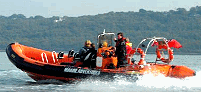
 Of course, availability of a man-carrying boat, such as a RIB (Rigid Inflatable Boat) would have been extremely useful in the past.
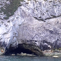
e.g. photo recce near that Isle of Wight north coast soon after the "crash landing" in November 2012.
This was only done many months later - that possible sighting of an overturned Snoopy near a cave.
It might have been the only practical solution to rescue Snoopy in October 2013 - if Dick had not done it first ! :-)
Of course, availability of a man-carrying boat, such as a RIB (Rigid Inflatable Boat) would have been extremely useful in the past.
e.g. photo recce near that Isle of Wight north coast soon after the "crash landing" in November 2012.
This was only done many months later - that possible sighting of an overturned Snoopy near a cave.
It might have been the only practical solution to rescue Snoopy in October 2013 - if Dick had not done it first ! :-)
 The quick answer to this is "Yes, and I know a man who knows more than all of us". He works at the UK Hydrographic Office ;-)
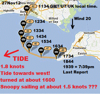
I've had many emails on this subject, and many from experienced sea-going sailors, some of whom are familiar with the strong tidal currents around the Isle of Wight, particularly near The Needles and the entrance to The Solent. This became a particularly "hot topic" after Snoopy's November 2012 Atlantic Attempt, when everyone - including myself - assumed he had started his movement east, towards the Needles, due to the effect of the tide, and was simply being swept along by it. Click on the picture on the right, to see the other one, that try and show this simply.
The majority of the emails were not questions, but "comment" to me, suggesting that the tidal current was flowing in the same direction as Snoopy travelled. This was in early December, when I "woke up" to the fact that Snoopy had not simply been swept east by the tide - which was flowing in the opposite direction - towards the west. My computer predictions here, from the Hydrographic Office (HO) TotalTide model, were confirmed by the good man in the HO, who not only provided me detailed tidal current data along Snoopy's GPS track, but similar data for our GPS Bottle, that we'd tracked in the same area a year earlier.
 None of those who contacted me had the advantage of an HO Computer Model, that is simple to use, and far more reliable
than the complicated and error prone process of obtaining the same information (direction and speed of tidal current
at a particular place, date and time). They certainly did not have the help of the only real experts on this: the HO.
My friend John, plodded through the "manual process" with me, and I saw first-hand the difficulties
in it providing better than a rough indication. Along the way were all the "caveats" on various web sites,
the need to find "High Water" for somewhere suitably near, then look up the appropriate chart on another web site.
Plenty of scope to make mistakes, and plenty of scope for the web site information to be inacurate.
None of those who contacted me had the advantage of an HO Computer Model, that is simple to use, and far more reliable
than the complicated and error prone process of obtaining the same information (direction and speed of tidal current
at a particular place, date and time). They certainly did not have the help of the only real experts on this: the HO.
My friend John, plodded through the "manual process" with me, and I saw first-hand the difficulties
in it providing better than a rough indication. Along the way were all the "caveats" on various web sites,
the need to find "High Water" for somewhere suitably near, then look up the appropriate chart on another web site.
Plenty of scope to make mistakes, and plenty of scope for the web site information to be inacurate.
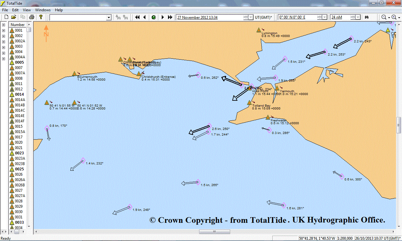
The TotalTide HO Model could not be easier to use: just type in a year, date and time, choose the map area, and there you see the calculated speed and direction of tidal current flow. Click on the chart on the right, to see TotalTide screen output clearly - for 13:34 on 27th November 2012, when Snoopy started to stray from his straight line path.
 Our "Thankyou..." section on
Snoopy's front page
has had this credit since December 2012:
Our "Thankyou..." section on
Snoopy's front page
has had this credit since December 2012:
"Chris at the UKHO (
UK Hydrographic Office
) for detailed tidal data, confirming that Snoopy was "snatched" :-)"
You could justifiably argue that I should have worded this better. e.g. "confirming to Robin". The important
thing was that Chris confirmed that Snoopy had sailed AGAINST the tide, which led to Robin, and others helping,
seeking other explanations to why Snoopy "wandered" on that day. The HO data also confirmed that the TotalTide model
could be relied upon.
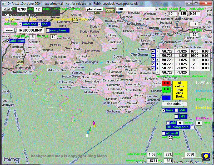
Robin had already been using this HO computer model for years, since the first GPS bottle project in 2004, where GPS bottles were tracked from off Ramsgate, to the French Coast, and as far north as Den Helder in Holland. More recently, in 2011, GPS bottles were launched by BBC Radio Solent , and their movements matched the tidal predictions of TotalTide, and movement based on 3% of wind speed. Here is the GPS track of a GPS bottle, showing clearly the cycle of the tide, and change from an offshore breeze to an onshore breeze.
Yes, the tide in this area IS complicated, and even more complicated than this model shows. e.g. the tidal eddy current around Alum Bay. But for the information we need, it provides good, reliable answers. Unfortunately, this model is expensive, and that's probably why all who have contacted me on this, have to rely on "doing it the hard way". However, having said all the above, don't hesitate to contact me. At the very least, it will prompt me to make the information on these pages clearer. Sometimes we discover information not shown by computer models :-)
Footnote added in November 2014: there is now a page which shows several hours of typical output from the TotalTide model. You may see it by clicking here.
 "Better the Devil you know" could be the short answer to this question.
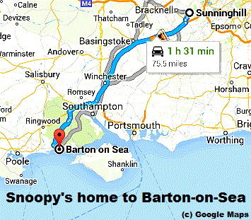
The above discussion, on this page, already gives background on why we continue to launch from Barton-on-Sea. This spot was originally chosen because it was relatively quick and easy to get to, down the M3, from our home in Sunninghill, near Ascot, Berkshire: less than 1.5 hours from our home, to the car park, near the Beachcomber Cafe. See Barton-on-Sea
When "things go wrong" - and they often do - it is easier to ask "what was different this time ?". Sometimes it can take weeks or months to discover what the cause of a failure was - but as said earlier, we can learn from our mistakes. We also have a lot of knowledge accumulated from earlier exercises, such as the BBC Bottle Tracking Project.
Barton-on-Sea is not too far from home, and has a good cliff-top observation spot near a nice cafe for refreshments - the Beachcomber Cafe. There are now a LOT of people we know in the wider area, who can keep an eye on the boat, including filming close approaches by unwelcome visitors (the 2012 attempt). Most of that southern UK coastline, including the Isle of Wight, is accessible, should Snoopy need to be rescued (the 2013 attempt). If we need to stay down there, because Snoopy is seen to be "wandering", that's easier, because we are not so far from home.
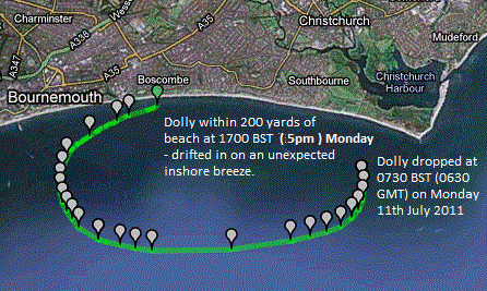
Footnote added on 8th September 2014: a lot more are going to ask "Why Barton-on-Sea ?" after Snoopy's September Attempt at the weekend. We knew it was a risk in that almost non-existant wind, and the tactic of launching just as the tide was turning to flow west, nearly worked. Next time, we may well launch from a little further west along that same bit of coast, such as Highcliffe, just three miles, from where we observed Snoopy. Or maybe that nice sandy beach, eight miles west, past Boscombe Pier, not far from Bournemouth. Boscombe is where GPS Bottle Dolly Dorset came ashore to Party, a few years ago. These places all seem to sell ice cream :-)
 The short answer is "yes", and so compass-steering does not stop us considering the tide, when choosing when and where to launch.
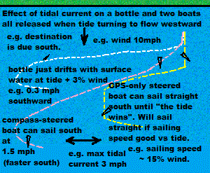
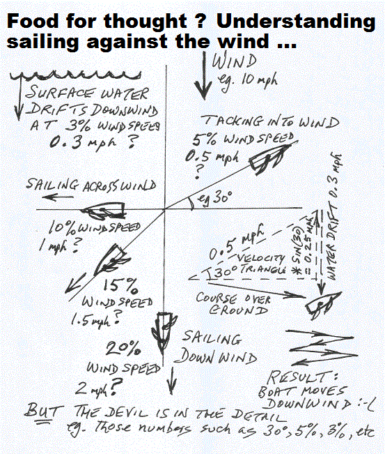
We are begining to have a better understanding of how our "GPS-Only" steered boats will behave in a strong tide, and in September 2014, while on holiday, this picture and words were added to the blog: ... If we can predict the behaviour of Snoopy's boat, for particular wind speed and direction, and the changing tidal current speed and direction, we are more likely to avoid mishaps like landing on the Isle of Wight !
On the right is a picture which tries to explain some of the things we have learnt in recent years. e.g. a bottle, just drifting on the surface, will move at about 3% of the wind speed, downwind, and will also move with the tide. So if the wind is from the north, and the tide is flowing west, the bottle will move to the West-South-West, in a direction that varies with the tide. The bottle will progress south at 0.3 mph (3%), regardless of what extra velocity the tide gives it. ... The advantage of a compass-steered boat, in this situation, is that it can simply point south, and make it's sailing speed, of perhaps 1.5 mph (15% downwind), even though the tide will carry it even further in the east-west-east direction. Therefore, a compass steered boat will need even more condideration of strong tide than our current and past GPS-only systems.
The third example here is for our GPS-only steered boats. We are still quantifying at what combination of tide speed and wind speed, the "tide wins". Sailing speed, for our boats, seem to be about 15% of wind speed, when sailing downwind, and nearer 10% when sailing cross wind.
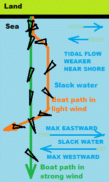
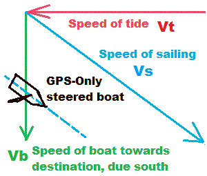 A little more thought, and schoolboy trigonometry, enables us to estimate roughly, when the GPS-Only autopilot
will be "overcome" by the tide. You may recognise a "velocity triangle" on the right.
The resultant speed and direction of the boat is the combination of it sailing through the water,
and the tidal current. If I remember Pythagoras correctly, Vs = SQRT( Vt*Vt + Vb*Vb ) or - more usefully,
Vt = SQRT ( Vs*Vs - Vb*Vb ).
A little more thought, and schoolboy trigonometry, enables us to estimate roughly, when the GPS-Only autopilot
will be "overcome" by the tide. You may recognise a "velocity triangle" on the right.
The resultant speed and direction of the boat is the combination of it sailing through the water,
and the tidal current. If I remember Pythagoras correctly, Vs = SQRT( Vt*Vt + Vb*Vb ) or - more usefully,
Vt = SQRT ( Vs*Vs - Vb*Vb ).
If the boat's actual speed slows down to near 0.1 mph/knot, the GPS will not give accurate speed and direction of movement. This is why Snoopy usually drifts to the bank, when on 24/7 test, and if the wind drops.
This means we can do a rough calculation of how fast the tide must move to "win". Suppose the sailing speed is 1.5 mph, then Vt = SQRT ( 2.25 - 0.01 ) = a "teensy weensy bit less than 1.5mph". i.e. for all practical purposes, we can say that the boat should sail straight towards it's destination, until the tidal current speed approaches the sailing speed.
We can also calculate the effect of the tide, on the forward speed of the boat, seen on the SPOT map. Suppose the boat is sailing at 1.5mph through the water, but the tide is flowing at 1mph: the actual speed of the boat, Vb = SQRT (1.5*1.5 - 1*1) = SQRT(1.25) = about 1.1mph !
So, in conclusion: we would expect our GPS-Only boats to sail in a straight line, towards their destination, until the speed of the tide approaches the boat sailing speed. Also: the speed of the boat, towards it's destination, will decrease. This seems to match what we have observed, over the years, and may help us "guess better" the behaviour of our boats. Real conditions are obviously not so simple: e.g. the tide may not be at right-angles to the boat's intended direction, and things like wind and sailing speed may be less predictable than the tide.
 We have a new
Tide Page
which has more detail related to the tide, and robot boat behaviour in
Snoopy's launch area, near Bournemouth.
We have a new
Tide Page
which has more detail related to the tide, and robot boat behaviour in
Snoopy's launch area, near Bournemouth.
![]()
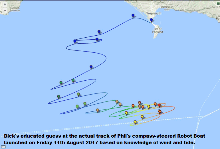
Below added on 18th August 2017. Well Done Phil ! :-)
Below added on 1st November 2017. Food for thought ? :-)
![]() Maybe a student wants to write a computer model, to predict this boat behaviour, as I did for our GPS bottles, 10 years ago ?
Maybe a student wants to write a computer model, to predict this boat behaviour, as I did for our GPS bottles, 10 years ago ?
We don't need such a computer model now, and I would rather spend what time I have on other things. However, I'll be happy to give a few tips to anyone who intends to tackle something similar to my DRIFT model: particularly if others can make use of the model: it's predictions would be interesting, and may be useful.
More detail about the DRIFT model is on this old GPS Bottle Page, and the animated picture on the right was produced by the model. Click on the picture to see the larger version.
Please don't be confused by the picture on the left: we never did reach the stage of fitting sails to the bottles :-)
Footnote on 8th November 2014: I just found a copy of my old DRIFT model on this Windows 7 PC, and was pleasantly surprised to see that it ran, and also that I must have used it again, during the BBC Bottles Project, several years later. I see that I had already changed the map from near Dover-Calais, to Snoopy's launch area - which is also where the BBC GPS Bottles were launched. This might be a good starting point, if someone wishes to do any related modelling work.
 Here is a question from Robin: he is sure there is a very simple answer, although
finding the answer may involve calculus, and the last time he used that was in the 1960s - at Uni'.
Here is a question from Robin: he is sure there is a very simple answer, although
finding the answer may involve calculus, and the last time he used that was in the 1960s - at Uni'.
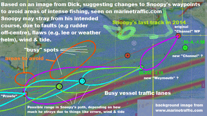
Here is the question: what is the simple formula, that gives the maximum deviation from the straight line, m, between two waypoints, as a function of the distance between the two points, d, and the steering error in degrees, e ?
Why are we interested ? Mostly curiosity, but it might be useful to know, when choosing the position of waypoints, to avoid the risks of getting too close to things like land, or intense fishing areas. Those yellow, blue and purple "tear drop" shapes, drawn by Dick, are probably the right shape. They are for the steering error we experienced, of about 20 degrees, due to the rudder not being exactly central on our GPS-only autopilot. Note that other robot boats, with very different autopilots, might suffer similar steering errors. e.g. inaccuracy of a compass system, include tilt-compensation, and conversion from magnetic to true north.
If I were to guess at what the answer might look like, it might be something like m = k * tan ( e ) - but that's just a guess. i.e. when the error is zero, the deviation is zero. As the error approaches 90, the deviation will approach infinity. There are probably values of e where the boat would move in a spiral, either getting closer to the next waypoint, or further away.
If someone comes up with the answer, I will be very pleased to credit them here.
Thanks to Dermot on the Microtransat List, we seem to have the answer, and it's a simple one:
m = d * SIN(e). This m is more commonly known as the "cross track error".
For the case where e=90, it seems the track will be a circle. For some lesser values, it will be a spiral.
Thanks Dermot :-)
© 1991-2017 Robin Lovelock. Please credit www.gpss.co.uk if you use material from any of these pages. Thankyou.