Home
GPS
Download
Business
Partners
Contact
Family
AVL
Links
History
AsOnTV
GPSS in Logistics - at Base and in the Cab
Last Updated 0900 UK Friday 12th September 1997
Home
GPS
Download
Business
Partners
Contact
Family
AVL
Links
History
AsOnTV
GPSS in Logistics - at Base and in the Cab
Last Updated 0900 UK Friday 12th September 1997
GPSS, or 'Global Positioning System Software', has been developed for use within cars, but it is also used to track a number of vehicles from a fixed Basestation. Many of the facilities are common to both types of application. e.g. map display and verbal description of where a selected vehicle is: "we are 25 miles west of London and 3.5 miles south of Ascot". It was designed for the future mass market - when we all have computers in our cars, but is rapidly being exploited by the military and police community.
It's advanced facilities and economic pricing makes it particularly attractive for use by fleet operators - either back at base, or within the vehicles.
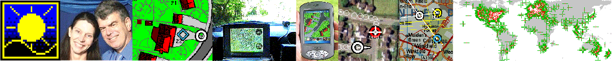
In a typical system, the vehicles are equipped with GPS receivers - to automatically locate their position, and communications to exchange messages with the Basestation. This might share voice radio, or use Inmarsat-C satellite communications, Cellular Telephone, or the Securicor Datatrak system. Choice of communications bearer will depend upon trade-offs in vehicle equipment cost, communications rental cost, and communications coverage.
The Basestation is provided with a PC computer running the GPSS software. Regular position reports enable the vehicles to be automatically plotted on the displayed map. Coded messages can be used to report incidents from the vehicles - such as a breakdown or accident, and send orders from the Basestation to the vehicles.
An Inmarsat-C based GPSS system is already in operational service with a UK Police Constabulary and is being evaluated by a host of other organisations - including those involved in the Logistics Community.
GPSS provides easy to use facilities to monitor the vehicles on detailed displayed maps which can be zoomed, and automatically selected to follow individual vehicles. Messages, including position reports from the vehicles, can be automatically printed and/or recorded to files for archives, and for 'playing back' on the map with the same software.
All the 'in-car' facilities of GPSS are also available for Multiple Vehicle Tracking. e.g. searching for the nearest village to a particular vehicle; calculation of where a selected destination is from the vehicle; output of this information by voice in addition to map display; use with voice recognition, in addition to conventional mouse and keyboard operation.
GPSS can be supplied with digital mapping from a variety of sources including the US Defence Mapping Agency, Ordnance Survey, Bartholomew's, and ESR.
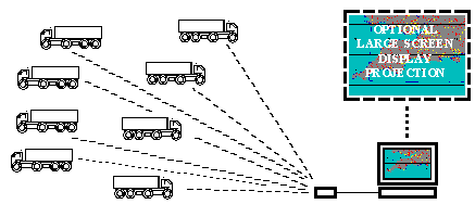
GPSS can also be used within a PC in the cab, providing all the obvious navigation aids - but also controlling communications and automatic logging of tasks.
For technical information, prior to downloading the files to demonstrate and use this GPSS capability, please click here