How do I use this mapping ?
For those who do not know already, these are the steps you must
follow:
- Test the GPSS Baseline from the
download page with GPS->Laptop PC running GPSS.
- Fill in the "Quiz" answers in step 2 on the same page - to get free support.
- Use the tips given in my reply, to add more local mapping from the
USA download pages. This will normally include USADISK.EXE
or modules with more detail near you. These EXE downloads include sound files
and WAW files which control things such as GPSS speaking your position relative
to towns in the USA instead of London.
How is the mapping organised ?
 The vector data is organised into self-extracting EXE files,
each covering an area of 1 degree latitude x 1 degree longitude.
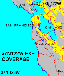
i.e. approx 60 miles north-south. e.g. 37N122W.EXE holds
data for the San Francisco area, 37N to 38N and 122W to 121W.
The vector data is organised into self-extracting EXE files,
each covering an area of 1 degree latitude x 1 degree longitude.
i.e. approx 60 miles north-south. e.g. 37N122W.EXE holds
data for the San Francisco area, 37N to 38N and 122W to 121W.
Each EXE file will be in the ballpark of 1 MB.
e.g. 37N122W.EXE is 1,002,924 bytes, and 37N121W.EXE is 846,928 bytes.
You can download the data simply by opening the appropriate URL, such as
http://www.gpss.co.uk/usa/37N122W.EXE
- or, if you are getting a slow response from www.gpss.co.uk,
try the mirror site on gpss.npl.com
http://gpss.npl.com/usa/37N122W.EXE
PLEASE NOTE THAT THESE EXE FILES ARE UPPER CASE.
There are 1192 EXE files, each covering a 1 x 1 degree area,
but only five are above the 1.44 MB capable of being held
on a floppy disk. They are 33N117W for Los Angeles, 40N073W and 40N074W
for New York, 42N071W for Boston, and 40N075W for Philidelphia.
help us test new mapping
The mapping described above was uploaded onto gpss.co.uk/usa in early 2000.
Good progress is being made with processing the latest Tiger source DVDs into
the same GPSS-compatible format. You may wish to help us test the new pre-release data.
If so, you should follow the path of steps 1,2 and 3 on the download page,
until you have tested GPSS with the GPS, using the street level mapping described above.
You may then wish to testing with the latest pre-release version of the data from gpss.tripoduk.com/usanew
e.g.
gpss.tripoduk.com/usanew/37n122w.EXE
- note the use of lower case in the filename.
More details about this ongoing work are
here.
Things to Test
Here are a few things to test with GPSS and the USA vector mapping:
- Street names: check your local streets have the correct name. See below.
- track accuracy: If you find errors bigger than the 5m radius history circles,
please send Robin an
NME File recorded "around the block".
You can also use Control-A DRAW to REPLAY recorded trips.
- better presentation of display - ideas welcome.
- better speed - ditto - e.g. faster street name rotated text in v4.95e and later.
- simple piecemeal addition of mapping. e.g. automatic WAW in v4.95f
- any bugs, such as patches of streets missing (e.g. cache logic bugs).
See the OLDNEW page linked above for the very latest GPSS.EXE
Tips on Testing
Some tests can obviously be done "on the road",
but please get someone else to drive, while you look at the screen.
For those who want to test "on the desk", here are a few tips:
- run GPSS without your GPS connected.
- use Control-C STOP DEMO to switch off the demonstration.
- click with right mouse button to move the car.
- Z key should zoom out, and X zoom in to most detailed map.
- GPSS.EXE v4.95j introduced search of ALL the WAW files.
e.g. `new (then Enter) will find nearest place starting "new" e.g. Newcastle.
Enter key then finds next nearest. e.g. New York.
V key then "Visits" the location with the car.
`*york finds nearest which includes "york". e.g. York.
Enter key finds next nearest. e.g. New York.
`New York - should find it first time, of course.
TIGER ® Source data and TIGER.EXE
NOTE THAT YOU DO NOT NEED TO BUY THE SOURCE TIGER DATA.
IT HAS ALL BEEN PROCESSED INTO GPSS-COMPATIBLE FORMAT,
AND IS AVAILABLE FOR DOWNLOAD FROM WWW.GPSS.CO.UK/USA
The source "Tiger" data is US Government Public Domain, and so there are no
copyright fees to be paid to the US Government - unlike mapping for most other countries.
THE DATA ON THIS WEB SITE IS NOT PUBLIC DOMAIN.
PLEASE SEE THE COPYRIGHT STATEMENT BELOW.
Information on TIGER ® source data is on
www.census.gov/geo/www/tiger/
and may be purchased on 7 CDROMs for 490 USD. (i.e. 70 USD per CDROM)*
It can be downloaded from
www.census.gov/geo/www/tiger/tl_change.html
- but remember these are BIG files, of typically 5 to 15 MB each,
and for the USA, there are 3234 of them :-)
* this was cost in 1999: Robin just purchased the complete 2004 Tiger-line data,
released in August 2005,
on two DVD for 70USD + 25USD for overseas shipping.
TIGER.EXE is a program written by Robin, to process TIGER ® source data
into the GPSS-compatible form that can be downloaded from this web site.
Robin is happy to release information on this offline software, and the
format of the GPSS-compatible files, to those who have a "need to know".
e.g. business partners creating similar data for other countries.
TIGER.EXE already handles data from both TIGER ® and DCW (Digital Chart
of the World) and could be modified to process other sources into the
GPSS file formats.
For those thinking of "hacking" the files, for use with their own software,
please do not forget that this is strictly illegal. Also, it was not
difficult for the data
to be given a "signature" to trace it's origin from this GPSS data.
e.g. "hidden streets".
If you have a software talent, use it wisely ;-)
Here are some words from the TIGER ® README.TXT documentation file:
The TIGER/Line files were created from the Census Bureau's TIGER
(Topologically Integrated Geographic Encoding and Referencing) data base
of selected geographic and cartographic information. TIGER was developed
at the Census Bureau to support the mapping and related geographic
activities required by the decennial and economic censuses and sample
survey programs. TIGER/Line files are made available to the public and
are typically used by people to provide the digital map base for their
Geographic Information System or mapping software.
- and here are some more words from the TIGER99.PDF documentation file:
Census TIGER ® , TIGER ® , TIGER/Line ® , TIGER/SDTS ® , TIGER/Census Tract Street Index ® ,
TIGER/CTSI ® , CTSI ® , TIGER/Census Tract Comparability ® , and TIGER/GICS ® are registered
trademarks of the U.S. Census Bureau; ZCTA ™ is a trademark of the U.S. Census Bureau. As
such, these names cannot be used as or within the proprietary product names of any commercial
product including or otherwise relevant to U.S. Census Bureau data, and may only be used to
refer to the nature of such product. The U. S. Census Bureau requests that any repackaging of the
TIGER/Line ® data (and documentation) and other files accompanying it for distribution include
a conspicuously-placed statement to this effect on the product's cover, the first page of the
website, or elsewhere of comparable visibility. Further, U.S. Census Bureau trademarks, when
used in reference to the nature of the product, should be accompanied by the ® (registered)
symbol or ™ symbol, where convenient.
change history for vector mapping in GPSS
Here are some details, most of which have been on this page for years.
updates to street level mapping - October & November 2005
See "help us test new mapping" above.
Water bug until v5.96 GPSS - October 2005
I'm grateful for the good work of Martin Brilliant in USA for bringing my attention
to a major omission in GPSS.EXE which stopped it plotting the water details in *W.VEC
files. This omission - or bug - has been in GPSS for years. The fix was put onto
the oldnew
page in October 2005, and will be in all copies of GPSS v5.96 and later. Thanks Marty :-)
Minor Zoom bug in v5.3 GPSS - June 2002
The v5.3 Baseline of GPSS included the DES files, but not the VEC
files contained in the EXE downloads. A minor bug in GPSS.EXE v5.3
results in the Z key (Zoom) not responding as you would expect if
no VEC files have yet been added. i.e. you need to hit Z a number
of times to step past the missing vector maps. Most will be happy
to live with this bug, which was fixed in the pre-release v5.4
of GPSS.EXE available on the
oldnew page, and all copies of GPSS after v5.3.
Remaining Problems - in 2002
There have not been any new problems reported for over a year, with
new users each day registering GPSS and making use of this free
mapping. However, we have had reports, made some time ago, of
problems with data in the extreme north-east of USA. If you
experience problems yourself, please report them to me, after
obtaining free registration and a REF code to quote for free support.
GPSS.EXE v5.1 April 2001
The v5.1 24 April 2001 Baseline of GPSS includes changes
made to fix bugs (described below) in the v5 January 2001 Baseline.
Prior to the v5.1 Baseline appearing on the GPSS
DOWNLOAD
Page, pre-release versions of GPSS.EXE were available on the
OLDNEW Page.
The old v5 (January) baseline of GPSS worked with this
new vector mapping, but improvements were made
to the GPSS.EXE logic. The main
benifits in v5.1 are:
- fixing of the bug which caused occasional gaps
in street mapping due to wrong caching logic.
- automatic zooming out until the map includes
streets or roads - other than just a major highway.
This should solve problems crossing into Canada
or Mexico. It should also provide a more useful map
in remote area, where there is only the major highway.
Further changes are expected to this logic soon.
Street Name Bug found by Patrick - February 2001
Early spot checks on GPSS using the data showed it looked OK,
when compared against other sources, such as Streets 2001.
However, Patrick Jankowiak was the first to find
errors in the 32N096W.EXE data, resulting from a bug in my (Robin's)
offline TIGER.EXE software.
The error was found on 6th Feb 2001, TIGER.EXE corrected, and a corrected
32N096W.EXE uploaded after the 8th February re-run of TIGER.EXE.
On 1st March 2001 all data was replaced by the corrected files.
If you find a problem, of streets having the wrong name,
please tell me.
Please provide information, such as this from Patrick:
wrong name - correct name - lat/lon location
GRAND PLZ - GRACEY AVE. - 324153N0964771W
AVENUE G - ATLAS ST. - 324146N0964769W
etc. One or two examples are all I need from you.
Thank's Pat - for finding this (data) bug, and Tom Alcorn for finding
other examples, plus the bug in the GPSS.EXE cache logic - corrected
in v5.1 of GPSS.EXE.
Corrections to Street Data - March 2001
On Thursday 1st March 2001, all EXE data in www.gpss.co.uk/usa was replaced by
corrected data. This was to fix the "street name bug" described below.
i.e. a small proportion of streets in the old data had the wrong name,
starting with the same first letter.
more information about TIGER.EXE ...
You may read more information about TIGER.EXE and the methods
used to create the VEC files used by GPSS
here.
© 1991-2005 Robin Lovelock, Sunninghill Systems.
Any links to this web site
should be direct into the homepage of www.gpss.co.uk.
Robin Lovelock, Sunninghill Systems, 22 Armitage Court, Sunninghill, Ascot, Berks SL5 9TA, United Kingdom.
Sunninghill Systems International Limited and Sunninghill Software Limited are registered at the above address.

 Hi Folks ! This page tells you what you need to know to download
and use the GPSS USA street level mapping, first released here in early 2001.
Little has changed on this page in recent years.
Hi Folks ! This page tells you what you need to know to download
and use the GPSS USA street level mapping, first released here in early 2001.
Little has changed on this page in recent years.
 We are about to update the USA street mapping based on the latest Tiger/Line source data.
The TIGER.EXE program has been modified to run under Windows XP and the
slow process now takes a few hours instead of 10 days - as it did in 1999/2000.
Luckily we only have to do this once - correctly, before we upload the
final result onto gpss.co.uk for your download and use.
The picture at top right shows the level of detail available for
all the USA. This is the default scale at which the mapping is used.
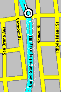
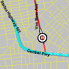
The picture on the left shows an example at two scales wider.
We are about to update the USA street mapping based on the latest Tiger/Line source data.
The TIGER.EXE program has been modified to run under Windows XP and the
slow process now takes a few hours instead of 10 days - as it did in 1999/2000.
Luckily we only have to do this once - correctly, before we upload the
final result onto gpss.co.uk for your download and use.
The picture at top right shows the level of detail available for
all the USA. This is the default scale at which the mapping is used.
The picture on the left shows an example at two scales wider.